GeoXO (Geostationary and Extended Orbits)
EO
Ocean colour instruments
Atmosphere
Ocean
Quick facts
Overview
| Mission type | EO |
| Agency | NOAA |
| Mission status | Considered |
| Measurement domain | Atmosphere, Ocean, Land |
| Measurement category | Cloud type, amount and cloud top temperature, Liquid water and precipitation rate, Atmospheric Temperature Fields, Cloud particle properties and profile, Aerosols, Multi-purpose imagery (ocean), Radiation budget, Multi-purpose imagery (land), Surface temperature (land), Surface temperature (ocean), Atmospheric Humidity Fields, Ozone, Trace gases (excluding ozone), Atmospheric Winds, Lightning Detection |
| Measurement detailed | Cloud top height, Precipitation Profile (liquid or solid), Ocean imagery and water leaving spectral radiance, Downward long-wave irradiance at Earth surface, Cloud cover, Cloud optical depth, Precipitation intensity at the surface (liquid or solid), Aerosol optical depth (column/profile), Cloud type, Cloud ice content (at cloud top), Cloud imagery, Aerosol Extinction / Backscatter (column/profile), Cloud liquid water (column/profile), Upward long-wave irradiance at TOA, Cloud drop effective radius, Aerosol effective radius (column/profile), Fire temperature, Fire fractional cover, Downwelling (Incoming) solar radiation at TOA, Atmospheric specific humidity (column/profile), O3 Mole Fraction, Atmospheric temperature (column/profile), Land surface temperature, Sea surface temperature, CH4 Mole Fraction, HNO3 (column/profile), NO2 Mole Fraction, Precipitation index (daily cumulative), Cloud top temperature, Wind profile (horizontal), Atmospheric stability index, Volcanic ash, CO2 Mole Fraction, SO2 Mole Fraction, Downward short-wave irradiance at Earth surface, Total lightning density, Aerosol Layer Height, Water vapour imagery, HNO3 Mole Fraction, NH3 Total Column |
| Instruments | GEOXO Imager, GEOXO LM, GEOXO Ocean Color, GEOXO Sounder, GEOXO Atmospheric Composition |
| Instrument type | Ocean colour instruments, Imaging multi-spectral radiometers (vis/IR), Atmospheric chemistry, Atmospheric temperature and humidity sounders, Lightning sensors |
| CEOS EO Handbook | See GeoXO (Geostationary and Extended Orbits) summary |
GeoXO (Geostationary and Extended Orbits) Mission of NOAA
Development Status References
Overview
NOAA's GeoXO satellite system is the ground-breaking mission that will advance Earth observations from geostationary orbit. GeoXO will supply vital information to address major environmental challenges of the future in support of U.S. weather, ocean and climate operations. 1) 2)
The GeoXO mission will continue and expand observations provided by the GOES-R Series. GeoXO will bring new capabilities to address emerging environmental issues and challenges that threaten the security and well-being of every American.
NOAA is working to ensure these critical observations are in place by the early 2030s as the GOES-R Series nears the end of its operational lifetime.
Advancing NOAA's Mission
GeoXO will watch over the Western Hemisphere as part of a NOAA observing system that provides world-class environmental information to support both long-term planning and short-term response. This observing system will power increasingly sophisticated models that forecast climate-change-driven weather patterns never seen before.
The GeoXO satellites will also host space weather instruments and its ground system will provide services for NOAA's deep space weather satellites.
With GeoXO, made-to-order data delivery will allow users to customize data access to facilitate more accessible and usable environmental information. Multiple data delivery options will be available, including an internet storefront, mobile device access, and satellite broadcast. Cloud-based product generation will expand data access, increase community involvement, and continuously evolve service.
Sensor Complement
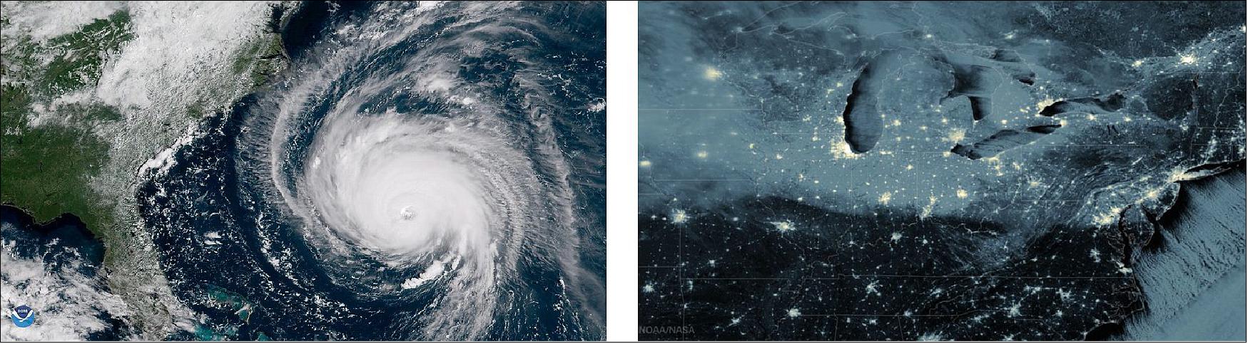
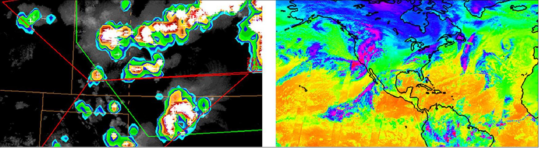
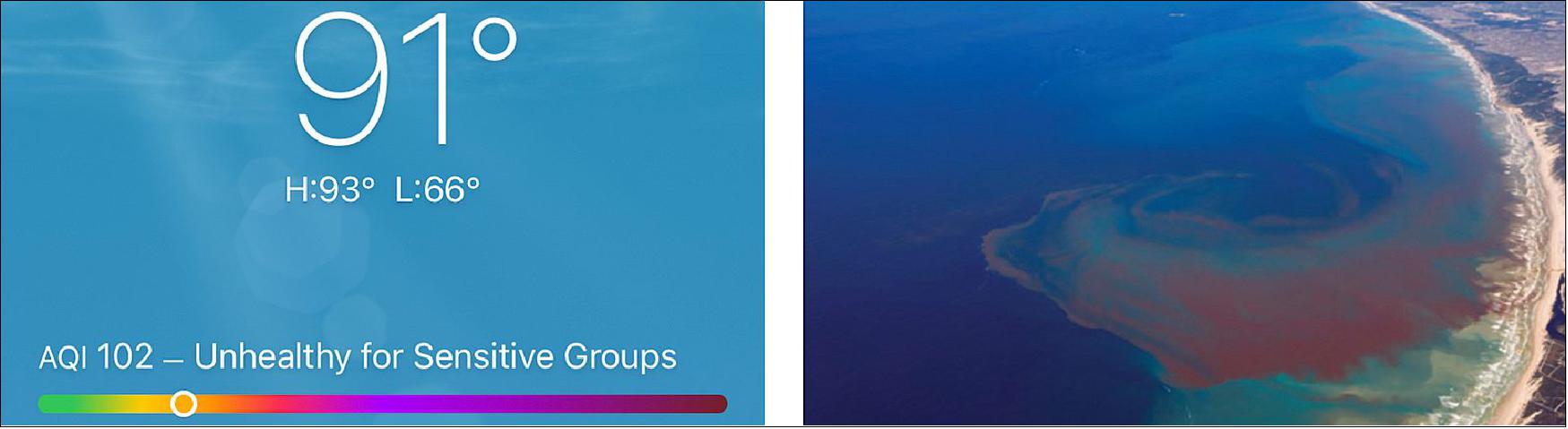
New technology and scientific advancements will improve observations for weather forecasting and provide new ocean and atmospheric measurements. GeoXO will provide real-time, high-resolution visible and infrared imagery for monitoring Earth's weather, oceans, and environment. Data from GeoXO will contribute to weather forecast models and drive short-term weather forecasts and severe weather warnings. GeoXO will also provide advanced detection and monitoring of environmental hazards like wildfires, smoke, dust, volcanic ash, drought, and flooding.
Additional observations are recommended to address our changing planet and evolving user needs. NOAA plans to incorporate day/night visible imagery, infrared sounding, atmospheric composition, and ocean color, as well as an improved lightning mapper in the GeoXO system, pending program approval. These observations will provide vital data to complement those from NOAA's partners in Europe and Asia, building a critical global observing system.
User Needs Inform GeoXO Capabilities
NOAA, its users, and industry partners conducted a number of capability studies, observation simulation experiments, value assessments, future scenario evaluations, societal and economic benefit evaluations, and user needs workshops, surveys, and interviews to determine which observations are the highest priority for GeoXO to provide.
GeoXO Core Capabilities | GeoXO Recommended Capabilities |
Visible/Infrared Imagery: Data continuity; spatial and Solar and Space Weather Monitoring: Data continuity (GeoXO Data Collection System Ingest: Service continuity Data Collection System (DCS), Service continuity; potential use of commercial services | Lightning Mapping: Data continuity; spatial resolution Infrared Sounding: New capability for numerical weather Day/Night Imagery: New capability for nighttime cloud, fog, Ocean Color Imagery: New capability for ocean health and Atmospheric Composition Measurement: New capability for |
Sustaining a Weather-Ready Nation
Supporting Healthy Oceans, Resilient Coasts, and Climate Science
GeoXO Core Capabilities | |
Visible/Infrared Imagery | Data continuity; spatial and spectral resolution improvements |
Solar and Space Weather Monitoring | Data continuity (GeoXO to accommodate space weather instruments) |
Data Collection System Ingest | Service continuity |
DCS, EMWIN, HRIT Data Rebroadcast | Service continuity; potential use of commercial services |
GeoXO Recommended Capabilities | |
Lightning Mapping | Data continuity; spatial resolution improvements |
Infrared Sounding | New capability for numerical weather prediction and nowcasting |
Day/Night Imagery | New capability for nighttime cloud, fog, and smoke tracking |
Ocean Color Imagery | New capability for ocean health and productivity monitoring |
Atmospheric Composition Measurement | New capability for detection of air quality threats |
Spacecraft
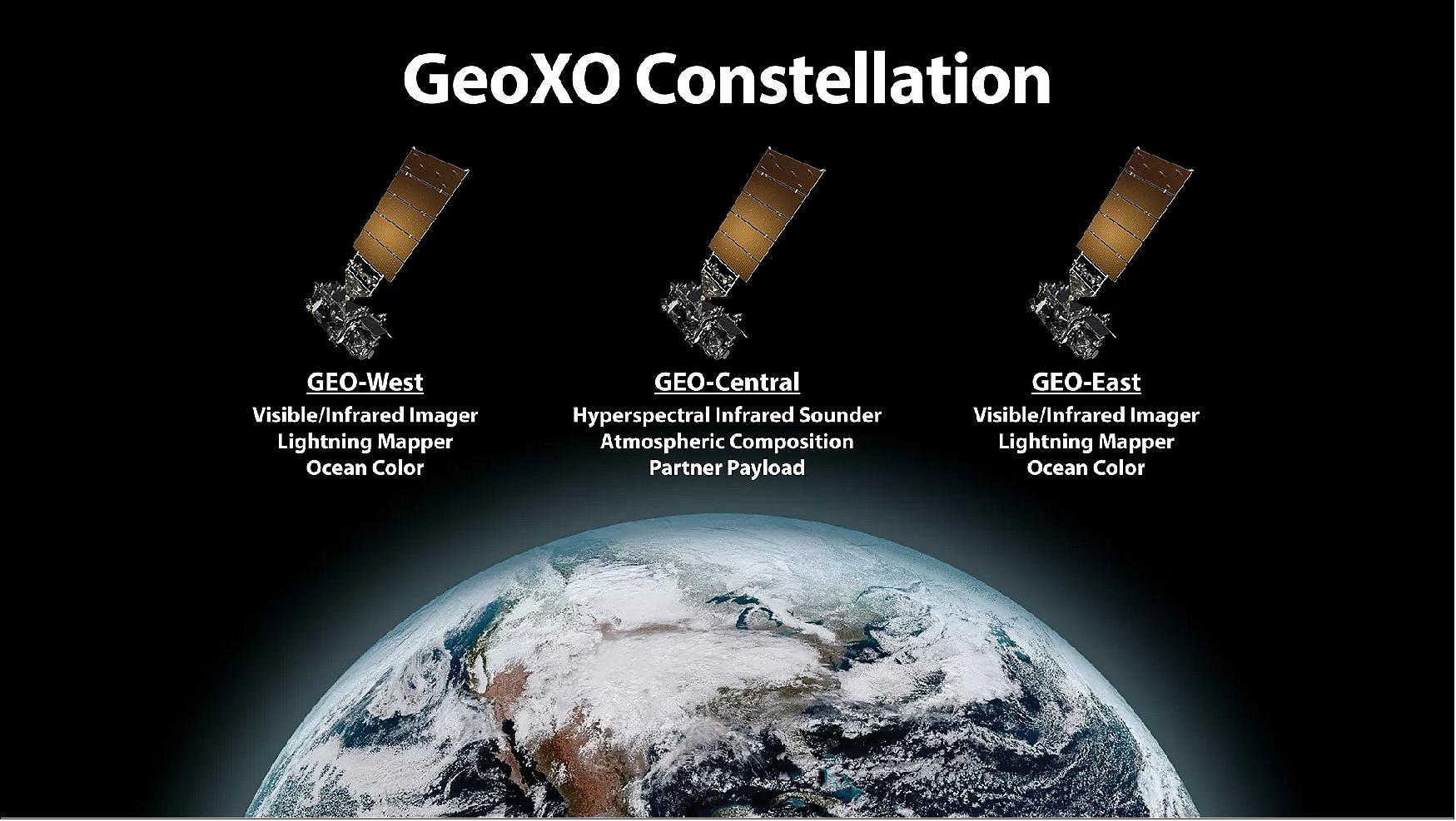
NOAA evaluated a range of space architecture options for delivering the recommended GeoXO observations effectively and efficiently. NOAA is currently planning, pending approval, a three-satellite GeoXO operational constellation. Spacecraft in the current GOES East and GOES West positions will carry an imager, lightning mapper, and ocean color instrument, and a centrally-located spacecraft will carry a sounder and atmospheric composition instrument. A day/night band, or channel, is recommended as part of either the imager or the sounder. This constellation can also accommodate a partner payload on the spacecraft flying in the central location.
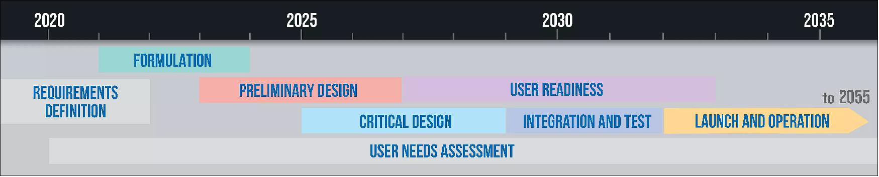
GeoXO Timeline
NOAA assessed user needs and studied a variety of potential observational capabilities. These analyses will inform key decisions to be made in 2021. Once the GeoXO requirements are defined, pilot studies will lead to the preliminary design of the spacecraft and instruments. As the program moves into the critical design stage, NOAA will begin preparing data users for new capabilities the GeoXO system will provide. The first GeoXO launch is planned for the early 2030s and will maintain and advance NOAA's critical geostationary observations through 2055.
Mission Status
• Nov. 9, 2021: NOAA's GeoXO Program Formally Initiated. The GeoXO Program was formally initiated following a successful Milestone 1 Review. GeoXO will now enter the program definition phase of development, where the team will refine mission requirements, detail acquisition strategies, schedules, cost estimates, resource planning, and risk management, and confirm technology readiness.
• July 23, 2021: The GeoXO Program was formally approved to begin the technology and development phase of the mission " Phase A" on July 21, 2021. The joint NOAA/NASA Agency Program Management Council affirmed the program addresses a critical need and the proposed mission concept is feasible. During Phase A, the GeoXO Program will develop the final mission concept, system-level requirements, necessary system technology developments, and program/project technical management plans.
Collaboration Delivers the Mission
GeoXO is a NOAA program, supported by NASA. NASA will manage the development of the satellites and launch them for NOAA, which will operate them and deliver data to users worldwide.
Industry partners are critical to meeting the mission. NOAA and NASA will work with commercial partners to design and build the GeoXO spacecraft and instruments. Instrument definition and design development studies are underway.
Phase A studies
NASA will award a number of contracts for "Phase A" studies as part of GeoXO instrument formulation activities. These definition-phase study and development contracts will help define each instrument's potential performance, risks, costs, and development schedule.
• On March 31, 2021, NASA awarded GeoXO Imager (GXI) Phase A study contracts to L3Harris Technologies, Inc., and Raytheon Company. Each company will conduct a one-year study to develop an infrared and visible imaging instrument concept and mature necessary technology.
• On September, 30, 2021 NASA selected Ball Aerospace & Technologies Corporation of Boulder, Colorado, for a GeoXO Sounder (GXS) Phase A Study to conduct a definition-phase study of a geostationary hyperspectral infrared Sounder instrument.
• On September, 30, 2021 NASA selected L3Harris Technologies Inc. of Fort Wayne, Indiana, for a GeoXO Sounder (GXS) Phase A Study to conduct a definition-phase study of a geostationary hyperspectral infrared Sounder instrument.
• On April 20, 2022, NASA selected Northrop Grumman Corporation System Sector of Azusa, California, and Lockheed Martin Corporation of Littleton, Colorado, to conduct GeoXO Lightning Mapper (LMX) Phase A Studies. Each company will conduct a twenty-month definition-phase study of a geostationary lightning mapper instrument.
Development Status
• May 27, 2022: Ball Aerospace and Raytheon Intelligence & Space will begin developing ocean color sensors for the National Oceanic and Atmospheric Administration's (NOAA) next generation of geostationary weather satellites under contracts announced May 26. 4) 5)
- Under the firm-fixed-price contracts awarded by NASA, NOAA's partner for the acquisition, each company will receive approximately $5.2 million to perform a definition-phase study of a passive imaging radiometer to provide frequent observations of ocean biology, chemistry and ecology.
- The ocean color instrument, known as OCX is a new addition to NOAA's geostationary fleet. The future constellation, called GeoXO (Geostationary and Extended Observations), will gather data related to ocean productivity, ecosystem change, coastal and inland water quality, seafood safety and hazards like harmful algal blooms.
- Beginning in the early 2030s, NOAA plans to operate three GeoXO satellites. Two will be flown over the Eastern and Western United States, like the current GOES-R series, plus a third satellite over the central United States.
- The OCX instrument will gather imagery in the ultraviolet through near infrared spectral bands. Ball and Raytheon will have 20 months to define the instrument's potential performance, risks, cost and development schedule. Based on the industry studies, NOAA will establish requirements for the OCX instrument implementation contract, which the agency plans to award in 2024.
- Ball and Raytheon won contracts earlier this month to begin developing GeoXO Atmospheric Composition instruments.
- Ball also is working on a definition Phase A study of a geostationary sounder for the GeoXO constellation. NASA awarded contracts valued at approximately $8 million apiece to Ball and to L3Harris in October.
• May 18, 2022: Ball Aerospace & Technologies Corp. and Raytheon Intelligence & Space will begin developing technologies for the National Oceanic and Atmospheric Administration's next generation of geostationary weather satellites under contracts announced May 17. 6)
- Under the firm-fixed-price contracts awarded by NASA, NOAA's partner for the acquisition, each company will receive approximately $5 million to perform a definition-phase study of the Atmospheric Composition instrument for the Geostationary Extended Observations program, called GeoXO.
- In addition to monitoring terrestrial weather, NOAA's GeoXO constellation, scheduled to begin launching in the early 2030s, will carry instruments to observe lightning, coastal ocean conditions and air quality. NOAA plans to operate GeoXO satellites over the Eastern and Western United States, like the current GOES-R series, plus a satellite over the center of the United States.
- The Atmospheric Composition instrument, called ACX, will gather imagery from ultraviolet through visible spectral bands. Ball and Raytheon will have 20 months to define the instrument's potential performance, risks, cost and development schedule. Based on the industry studies, NOAA will establish requirements for the ACX instrument implementation contract, which the agency plans to award in 2024.
- From its perch over the central United States, ACX will gather extensive data on atmospheric chemicals and aerosols.
- "One of those key measurements is going to be around air quality, which will inform us on the risk to our health and safety here on Earth," Matt Magaña, Raytheon Space Systems deputy vice president, told SpaceNews. "It's obviously critical to how we live our lives and the pollution that we have now created, and how we're going to observe those in the future."
- Raytheon completed a design study last year of a high-resolution imager for the GeoXO constellation. After that, the company formed a team "to identify and characterize the new pollution threats, how we're going to monitor them, how we're advancing those observations to deliver a long tail of next generation Earth-observation instruments," Magaña said.
- Ball also is working on a definition Phase A study of a geostationary sounder for the GeoXO constellation. NASA awarded contracts valued at approximately $8 million apiece to Ball and to L3Harris in October.
- Ball built the NASA-NOAA Suomi National Polar-orbiting Partnership satellite, launched in 2011, and the first Joint Polar Satellite System spacecraft launched in 2017. Meanwhile, Ball is manufacturing the Weather System Follow-On satellite for the U.S. Space Force and the company won a contract in 2020 to build, integrate and operate NOAA's Space Weather Follow On satellite destined for Sun-Earth Lagrange Point 1.
- Raytheon announced a $67 million contract in December from the Space Force to build a weather satellite to provide imagery of cloud cover and other data needed for military operations.
- Raytheon also manufactures the Visible Infrared Imaging Radiometer Suite (VIIRS) flying on Suomi NPP and the first Joint Polar Satellite System as well as the Moderate Resolution Imaging Spectroradiometer on NASA Terra and Aqua satellites.
• On May 17, 2022: On behalf of NOAA, NASA has selected two firms for the Geostationary Extended Observations (GeoXO) Atmospheric Composition (ACX) instrument Phase A Study. These firms will provide services to help meet the objectives of NOAA's GeoXO program. 7)
- Ball Aerospace & Technologies Corp. of Boulder, Colorado, and Raytheon Intelligence & Space of El Segundo, California will both receive twenty-month firm-fixed-price contracts for approximately $5 million. The work will be performed at the contractors' facilities.
- The principal purpose of this effort is to provide a definition-phase study of a GeoXO ACX instrument. The ACX instrument will be a hyperspectral, ultraviolet through visible imaging spectrometer that is planned to fly on the NOAA GeoXO series of geostationary satellites. The selected firms will develop the instrument concept and mature necessary technologies. The study will help define the instrument's potential performance, risks, costs, and development schedule. The results of the study will be used to set performance requirements for the ACX instrument implementation contract, which is planned for award in 2024.
- Atmospheric composition measurements from geostationary orbit will provide critical data for the air quality forecasting and public health communities. The instrument will monitor air pollutants emitted by transportation, power generation, volcanoes, and wildfires on an hourly basis, as well as pollutants generated from these emissions once they are in the atmosphere. This operational geostationary instrument will represent an important advancement over the once-per-day observations provided by current polar-orbiting instruments. These measurements will improve air quality forecasting and will help to mitigate health hazards resulting from air pollution, such as asthma, cardiovascular disease, and neurological disorders.
- NOAA's GeoXO satellite system is the groundbreaking mission that will advance Earth observations from geostationary orbit. The mission will supply vital information to address major environmental challenges of the future in support of weather, ocean, and climate operations in the United States. The GeoXO mission will continue and expand observations provided by the GOES-R series of satellites. GeoXO will bring new capabilities to address emerging environmental issues and challenges that threaten the security and well-being of every American. NOAA is working to ensure these critical observations are in place by the early 2030s,when the GOES-R Series nears the end of its operational lifetime.
- The GeoXO mission is a collaborative partnership between NOAA and NASA. NOAA funds, operates, and manages the mission and NASA's Goddard Space Flight Center in Greenbelt, Maryland, manages the acquisition of the Phase A formulation contracts.
• October 1, 2021: NASA awarded contracts to Ball Aerospace & Technologies and L3Harris Technologies to study instruments for Geostationary and Extended Observations (GeoXO), the National Oceanic and Atmospheric Administration's next generation of geostationary satellites. 8)
- The 20-month, firm-fixed-price contracts are valued at approximately $8 million apiece.
- Under the contracts announced Oct. 1, Ball Aerospace and L3Harris will conduct definition Phase A studies of geostationary sounders to inform NASA and NOAA's work to select the hyperspectral infrared instrument for the GeoXO constellation.
- NASA and NOAA are working together on the GeoXO mission. NOAA will provide funding, management and operations. NASA's Goddard Space Flight Center in Greenbelt, Maryland, is managing the acquisition of the Phase A contracts.
- In addition to monitoring weather, NOAA's GeoXO constellation, scheduled to begin launching in 2032, will be responsible for monitoring coastal ocean conditions and air quality. NOAA's preliminary plan for the GeoXO constellation calls for satellites over the Eastern and Western United States like the current GOES-R series plus a satellite over the center of the United States.
- Ball built the NASA-NOAA Suomi National Polar-orbiting Partnership satellite, launched in 2011, and the first Joint Polar Satellite System spacecraft launched in 2017. Ball is manufacturing the Weather System Follow-On satellite for the U.S. Space Force. In addition, Ball won a contract in 2020 to build, integrate and operate NOAA's Space Weather Follow On satellite destined for Sun-Earth Lagrange Point 1.
- L3Harris supplies the Advanced Baseline Imager (ABI) for the NOAA Geostationary Operational Environmental Satellite R series, the Cross Track Infrared Sounder for NOAA's Joint Polar Satellite System, Japan's Advanced Himawari Imagers and South Korea's Advanced Meteorological Instrument.
• March 31, 2021: NASA has selected L3Harris Technologies Inc. of Fort Wayne, Indiana, and Raytheon Company of El Segundo, California, for the Geostationary and Extended Orbits (GeoXO) Imager (GXI) Phase A Study contracts. The GXI Phase A Study requirement will provide services to help meet the objectives of the National Oceanic and Atmospheric Administration (NOAA) GeoXO program. 9)
- The total value of each of these one-year firm-fixed price contracts is approximately $6M. The work will be performed at the contractors' facilities in Indiana and California.
- The principal purpose of these contracts is to provide a definition-phase study of a geostationary Imager instrument. The Imager will be an infrared and visible imaging instrument that is planned to fly on the NOAA GeoXO program series of geostationary satellites, with the first launch planned for 2032.
- NOAA's GeoXO mission is the groundbreaking development of a satellite system that will advance Earth observations from geostationary orbit. The mission will supply vital information to address major environmental challenges of the future in support of weather, ocean, and climate operations in the United States. The GeoXO system will continue and expand observations provided by the GOES-R series of satellites. GeoXO will bring new capabilities to address emerging environmental issues and challenges that threaten the security and well-being of every American. NOAA is working to ensure these critical observations are in place by the early 2030s, as the GOES-R Series nears the end of its operational lifetime.
- The GeoXO program is a collaborative partnership between NASA and NOAA. NOAA funds, operates, and manages the program, and NASA's Goddard Space Flight Center in Greenbelt, Maryland, develops and acquires the mission system including management of the acquisition of the Phase A formulation contracts.
References
1) "Geostationary and Extended Orbits (GeoXO)," NOAA, March 2021, URL: https://www.nesdis.noaa.gov/sites/default/files/GEO-XO_FactSheet.pdf
2) "Geostationary Extended Observations (GeoXO),"NOAA/NESDIS, URL: https://www.nesdis.noaa.gov/next-generation/geostationary-extended-observations-geoxo
3) "NOAA GeoXO Program Formally Initiated," NOAA/NESDIS, 9 November 2021, URL: https://www.nesdis.noaa.gov/news/noaa-geoxo-program-formally-initiated
4) Debra Werner, "Ball and Raytheon to develop NOAA ocean sensors," SpaceNews, 27 May 2022, URL: https://spacenews.com/noaa-ocean-color-sensors/
5) "NASA Awards Contracts for NOAA Ocean Color Instrument Phase A Study," NASA Press Release, C22-006, 26 May 2022, URL: https://www.nasa.gov/press-release/goddard/2022/nasa-awards-contracts-for-noaa-ocean-color-instrument-phase-a-study
6) Debra Werner, "Ball and Raytheon win weather instrument study contracts," SpaceNews, 17 May 2022, URL: https://spacenews.com/ball-and-raytheon-weather-instruments/
7) Cynthia M. O'Carroll, "NASA Selects Firms for NOAA Atmospheric Composition Instrument Study," NASA Press Release, C22-005, 17 March 2022, URL: https://www.nasa.gov/press-release/goddard/2022/nasa-selects-firms-for-noaa-atmospheric-composition-instrument-study
8) Debra Werner, "Ball Aerospace and L3Harris win weather instrument study contracts," SpaceNews, 1 October 2021, URL: https://spacenews.com/ball-aerospace-and-l3harris-win-noaa-instrument-study-contracts/
9) "NASA Selects Geostationary and Extended Orbits Imager Phase A Contracts," NASA Press Release 21-002, 31 March, 2021, URL: https://www.nasa.gov/press-release/goddard/2021/nasa-selects-geostationary-and-extended-orbits-imager-phase-a-contracts-0
The information compiled and edited in this article was provided by Herbert J. Kramer from his documentation of: "Observation of the Earth and Its Environment: Survey of Missions and Sensors" (Springer Verlag) as well as many other sources after the publication of the 4th edition in 2002. - Comments and corrections to this article are always welcome for further updates (eoportal@symbios.space).
Development Status References Back to top