Hurricane Season 2012
Every year Hurricanes, Typhoons and Cyclones develop over the oceans. The storms that reach land can potentially cause devastation. With this year's season well under way, we will be featuring some related imagery to demonstrate these remarkable, and sometimes deadly, weather formations.
Please click the thumbnail images to view larger versions.
The season typically occurs between mid-May to the end of November, due to the warmer temperatures, but storms do sometimes form at other times of the year.
Storms that approach land are named so that they can be tracked by meteorologists.
- Cyclones take place over the Indian Ocean
- Hurricanes take place over the North Atlantic Ocean
- Typhoons take place over the Pacific Ocean
13 November 2012 - Impact of Hurricane Sandy
This map produced from Pleaides images shows Hurricane Sandy's impact on part of Port-au-Prince, Haiti. 54 people were killed in Haiti by Sandy, and 21 reported missing.
A great deal of damage was caused in Port-au-Prince by the heavy rains and strong winds.
This map was produced by SERTIT for disaster response, and for the purposes of the International Charter: Space and Major Disasters.
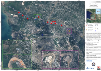
Credit: Pleiades images copyright of CNES 2012, distributed by Astrium Services / Spot Image S.A. all rights reserved. Map produced by SERTIT.
06 November 2012 - Aftermath of Hurricane Sandy
Beyond images of the storms themselves, satellites are, of course, also used to view the aftermath. This GeoEye-1 image shows Seaside Heights, New Jersey, on 31 October 2012, the day after Hurricane Sandy struck the area.
For perspective, also see the pre-Hurricane image of Seaside Heights, and a comparison between the two images.
These images show the destructive effect Hurricane Sandy had on Seaside Heights and other areas.
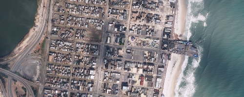
Credit: GeoEye
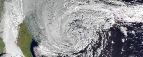
01 November 2012 - Remnants of Huricane Sandy
The Visible Infrared Imaging Radiometer Suite (VIIRS) on the Suomi NPP satellite acquired this image of the remnants of Hurricane Sandy around 3:13 a.m. Eastern Daylight Time (7:13 Universal Time) on 31 October.
A total of 146 people have been confirmed killed as a result of the storm in the affected nations. 24 states have been affected by the storm in the United States, and the long process of recovery has begun there and in the Caribbean islands affected by the storm in the days before.
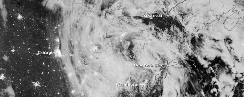
Credit: NASA Earth Observatory image by Jesse Allen, using VIIRS Day-Night Band data from the Suomi National Polar-orbiting Partnership (Suomi NPP). Suomi NPP is the result of a partnership between NASA, the National Oceanic and Atmospheric Administration, and the Department of Defense. Caption by Adam Voiland.
31 October 2012 - Hurricane Sandy
MetOp-A acquired another view of Hurricane Sandy as it hit the eastern coast of the United States of America on 29 October 2012.
The full scope of the storm has not yet been calculated, though 52 people have been reported killed so far in North America, as well as 70 in the Caribbean.
Hurricane Sandy became the largest hurricane in the recorded history of Atlantic storms, and was dubbed a "Superstorm". This was generated when the Hurricane came into contact with cold weather fronts from the Arctic. When the Hurricane made landfall the eye of the storm was 37 km in diameter.
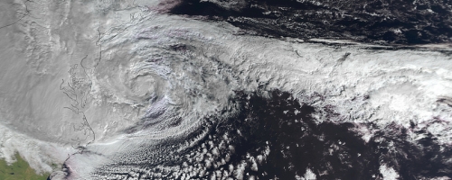
Credit: EUMETSAT 2012
30 October 2012 - Hurricane Sandy
The Geostationary Operational Environmental Satellite 13 (GOES-13) captured this natural-colour image of Hurricane Sandy at 1:45 p.m. Eastern Daylight Time (17:45 Universal Time) on 28 October 2012.
Sandy has battered the eastern coast of the United States and has caused an estimated 26 deaths so far. New York City was hit particularly hard, with damage to buildings and roads, and millions of people were left without power. Many of the subways tunnels have also been flooded.
New York and the surrounding counties have been declared a federal disaster area. The storm is now headed inland and is beginning to weaken away from the ocean.
NASA has released a gallery of satellite images for this event.
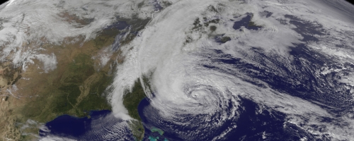
Credit: NASA Earth Observatory image by Robert Simmon with data courtesy of the NASA/NOAA GOES Project Science team.
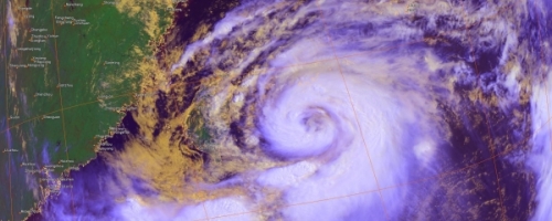
29 October 2012 - Hurricane Sandy
This MetOp-A image shows Hurricane Sandy approaching the east coast of the United States of America on 28 October 2012.
The eye of the storm is expected to make landfall before 31 October, and there are concerns the storm will grow in size as it makes contact with cold weather fronts. It is forecast to move up the eastern coast of the United States and Canada, and a state of emergency has been declared.
The populace in the affected coastal areas have been urged to evacuate or take shelter.
60 people have already been killed when the storm passed through the Caribbean last week.
Credit: EUMETSAT 2012
08 October 2012 - Typhoon Jelawat
EUMETSAT's new MetOp-B satellite acquired this view of Typhoon Jelawat on 29 September 2012, a few days before it hit Japan.
Jelawat was a category one storm when it made landfall on Japan, and caused over a hundred injuries and at least one fatality.
Credit: EUMETSAT 2012
21 September 2012 - Tropical Storm Nadine
EUMETSAT utilised their MetOp-A satellite to acquire this image of Tropical Storm Nadine as it passed close to the Azores on 19 September.
Nadine did not attain full Hurricane status, but nevertheless, the strong winds and rain were a hazard for islands in the Atlantic.
Tropical Storm Nadine has also been the subject of a NASA campaign, utilising their satellites and unmanned aircraft to track and study it.
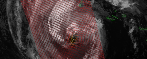
Credit: EUMETSAT 2012
31 August 2012 - Tropical Storm Isaac
NASA also captured this view of now-Tropical Storm Isaac, on 28 August, with Suomi-NPP. The image was acquired just after midnight and the storm clouds are lit by moonlight.
Though Isaac was downgraded to a Tropical Storm it has still caused widespread flooding and the strong winds have made relief and rescue efforts difficult.
Credit: NASA Earth Observatory image by Jesse Allen and Robert Simmon, using VIIRS Day-Night Band data from the Suomi National Polar-orbiting Partnership (Suomi NPP). Suomi NPP is the result of a partnership between NASA, the National Oceanic and Atmospheric Administration, and the Department of Defense. Caption by Mike Carlowicz.
30 August 2012 - Hurricane Isaac
NASA's Terra satellite captured this view of Hurricane Isaac on 28 August in the Gulf of Mexico. The sheer size of the storm can be appreciated in the full image.
Isaac has caused heavy flooding in the states of Louisiana and Mississippi but weakened and was downgraded to a tropical storm on the afternoon of 29 August.
Haiti and the Dominican Republic were also affected by the storm as it passed through earlier in the week, leaving at least 24 dead.
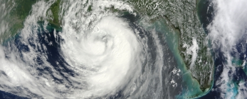
Credit: NASA image by Jeff Schmaltz, LANCE/EOSDIS Rapid Response
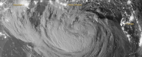
29 August 2012 - Hurricane Isaac
This MetOp-A image shows Hurricane Isaac as it struck New Orleans. A Category One Hurricane, Isaac struck the city of New Orleans exactly 7 years after the devastating Category Five Hurricane Katrina struck the city on 29 August 2005. The infrared image was acquired by the AVHRR/3 instrument.
Credit: EUMETSAT 2012
28 August 2012 - Hurricane Isaac
The X-Cam experimental microcamera aboard PROBA-2 captured this black and white view of Hurricane Isaac as the storm was moving into the Gulf of Mexico on 27 August.
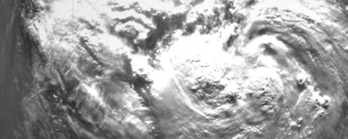
Credit: European Space Agency (ESA)
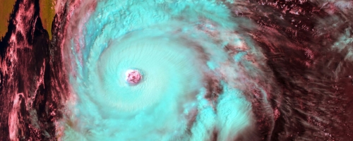
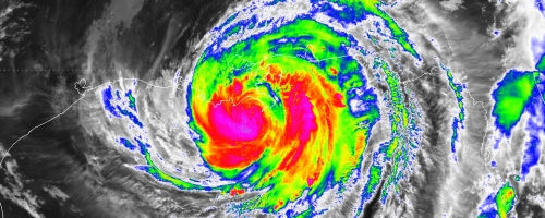
06 August 2012 - Typhoon's Saola and Damrey
This image from EUMETSAT's MetOp-A satellite shows Typhoon Saola (the smaller Typhoon Damrey can be seen in the full image) on its approach to China on 01 August. The two storms made landfall on 03 August within twelve hours of each other, leaving thousands homeless and two dead.
Saola had earlier passed through Taiwan and the Philippines, leaving widespread devastation in its wake.
Credit: EUMETSAT 2012