Hurricane Season 2013
Every year Hurricanes, Typhoons and Cyclones develop over the oceans. The storms that reach land can potentially cause devastation. Are are featured some related imagery to demonstrate these remarkable, and sometimes deadly, weather formations from 2013.
Please click the thumbnail images to view larger versions.
The season typically occurs between mid-May to the end of November, due to the warmer temperatures, but storms do sometimes form at other times of the year.
Storms that approach land are named so that they can be tracked by meteorologists.
- Cyclones take place over the Indian Ocean
- Hurricanes take place over the North Atlantic Ocean
- Typhoons take place over the Pacific Ocean
27 November 2013 - Tropical Cyclone Lehar
This MetOp-A image, acquired at 03:40 UTC by the AVHRR instrument on 26 November 2013, shows Tropical Cyclone Lehar in the Bay of Bengal on approach to the eastern coast of India.
The storm is expected to bring winds as strong as 200 kph and heavy rain and thousands of people have been evacuated from the affected areas in advance of the storm. It is expected to make landfall on 28 November.
Credit: EUMETSAT 2013
19 November 2013 - Typhoon Haiyan
This image from NASA's Aqua satellite presents another view of Typhoon Haiyan. Acquired at 05:10 UTC on 08 November 2013, this image shows Haiyan as it was passing over the Philippines with wind strength estimated to be 270 kph.
While early fears lead to an estimate of 10,000 people being killed by the storm, the Philippine government has since revised this estimates and currently the death toll is approximately 4000. Both local and international relief efforts are aiding some of the affected areas, restoring power and communications and providing food and water.
Credit: NASA Earth Observatory
11 November 2013 - Typhoon Haiyan
This image, acquired by the MTSat-2 and Meteosat-7 geostationary satellites of the Japan Meteorological Agency and EUMETSAT, shows Typhoon Haiyan as the powerful storm approached the Philippines last week at 13:00 UTC on 07 November 2013.
Typhoon Haiyan has been recorded as one of the worst storms in recorded history and is believed to have killed at least 10,000 people in the Philippines. The storm's strong winds, reaching excesses of 235km/h with 275km/h gusts, flattened many buildings, particularly the nation's vulnerable wooden homes.
In the Leyte province, the city of Tacloban was devastated, with a reported 80% of the city's homes destroyed. It is estimated that more than 9 million people in the Philippines have been affected by Haiyan.
Credit: Japan Meteorological Agency (JMA) / EUMETSAT 2013
22 October 2013 - Typhoon Francisco
This MetOp-B image, acquired at 00:43 on 22 October 2013, shows Typhoon Francisco over the Pacific Ocean.
As seen by the AVHRR instrument, Typhoon Francisco was moving north west at the time of this image and is forecast to change direction to the east and toward Japan later in the week.
It is of great concern to Japan, as it follows Typhoon Wipha which passed over Japan last week and killed over a dozen people. Francisco has been classified as the second strongest storm of this year and is expected to bring further flooding, strong winds and mudslides.
Credit: EUMETSAT 2013
08 October 2013 - Typhoon Danas
This MetOp-B image, acquired by the AVHRR instrument on 07 October 2013 at 00:55, shows Typhoon Danas approaching the Japanese island of Okinawa.
Danas would later that day pass over Okinawa and the Ryuku Islands bringing 120 kph (75 mph) winds and heavy rain. The northern part of the island suffered the worst of the storm.
Credit: EUMETSAT 2013
15 August 2013 - Typhoon Utor
This second image of Typhoon Utor was acquired by NASA's Aqua satellite, utilising the MODIS instrument, on 11 August 2013.
At the time of this image the storm was approaching the Philippines and had winds of 115 knots (213 kilometres per hour, or 132 miles/hr) and was rapidly strengthening. At its strongest, Utor was a Category 4 super typhoon, with estimated winds of 130 knots (240 km/hr or 150 miles/hr).
Credit: NASA Earth Observatory
14 August 2013 - Typhoon Utor
This MetOp-B image, acquired by the AVHRR instrument on 13 August 2013, shows Typhoon Utor in the South China Sea. At the time of this image, the storm was moving towards China and is expected to make landfall on the afternoon of 14 August, but it has already caused damage to the Philippines.
Classified as a super typhoon, Utor struck the Philippines on 12 August and has caused at least four deaths and resulted in torrential rains, mudslides and damage to buildings and infrastructure from strong winds which were measured at 150km/h (93 mph) at their peak.
Credit: EUMETSAT 2013
31 July 2013 - Tropical Storm Flossie
The Moderate Resolution Imaging Spectroradiometer (MODIS) on NASA's Aqua satellite acquired this image of Tropical Storm Flossie at 1:10 p.m. local time (23:10 Universal Time) on 28 July 2013.
Roughly two hours before the MODIS image was taken, the storm was centered at 19.9° North, 148.5° West. At the time, Flossie had sustained winds of roughly 60 miles per hour (50 knots or 90 kilometres per hour) and a pressure of 996 millibars. The storm was moving westward across the Pacific Ocean at roughly 20 miles per hour, headed for the Hawaiian Islands.
Not many tropical storms and hurricanes form in the central Pacific Ocean. Even fewer affect the Hawaiian Islands-just eight since 1979, according to meteorologist Jeff Masters. None have made direct landfall on the islands since Hurricane Iniki in 1992.
Credit: NASA Earth Observatory
26 February 2013 - Cyclone Haruna near Madagascar
This Meteosat-10 image shows the category two Tropical Cyclone Haruna in the Mozambique Channel as it approached Madagascar on 21 February 2013. Torrential rains and flooding followed Haruna's impact on the south-west area of the island, causing 17,000 people to be affected; including 13 deaths.
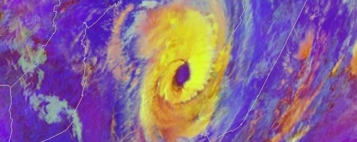
Credit: EUMETSAT 2013