Copernicus: Sentinel-2 - 2022
Copernicus: Sentinel-2 imagery in 2022
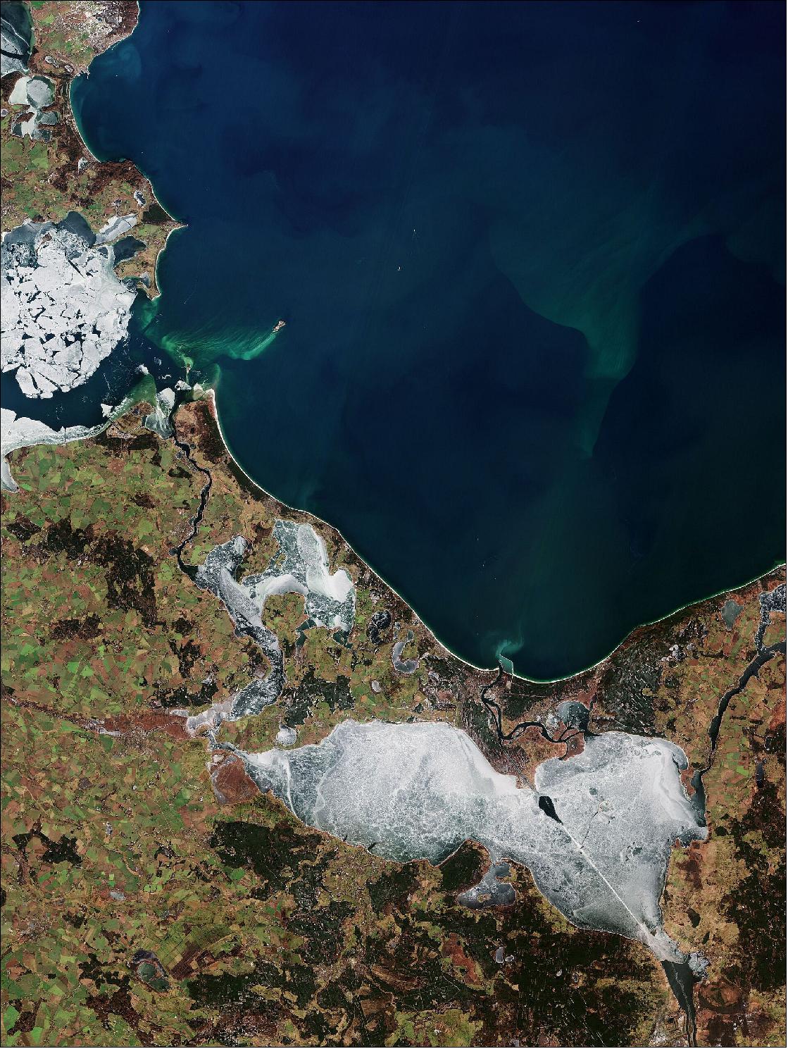
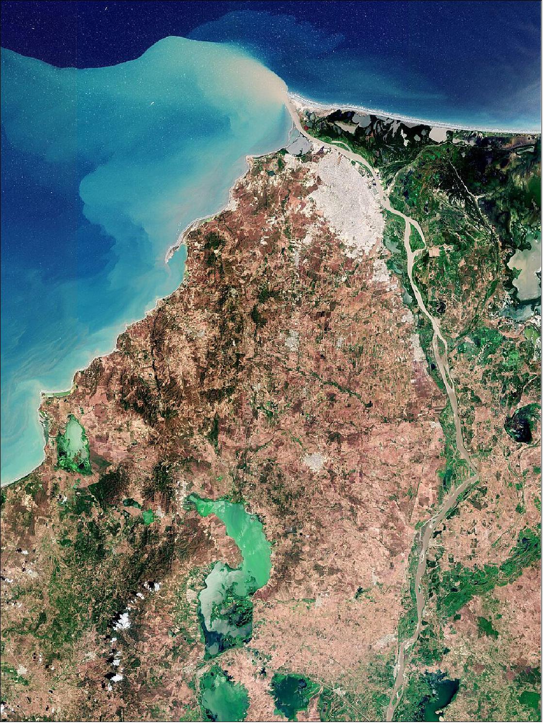
• January 21, 2022: Part of Mecklenburg–West Pomerania, also known as Mecklenburg-Vorpommern, a state in northeast Germany is featured in this image captured by the Copernicus Sentinel-2 mission. A portion of the northwest coast of Poland can be seen on the right of the image 1). Given this image was captured in February, it is most likely an onset of a spring bloom. Agricultural and industrial run-off pours fertilisers into the sea, providing additional nutrients algae need to form large blooms.
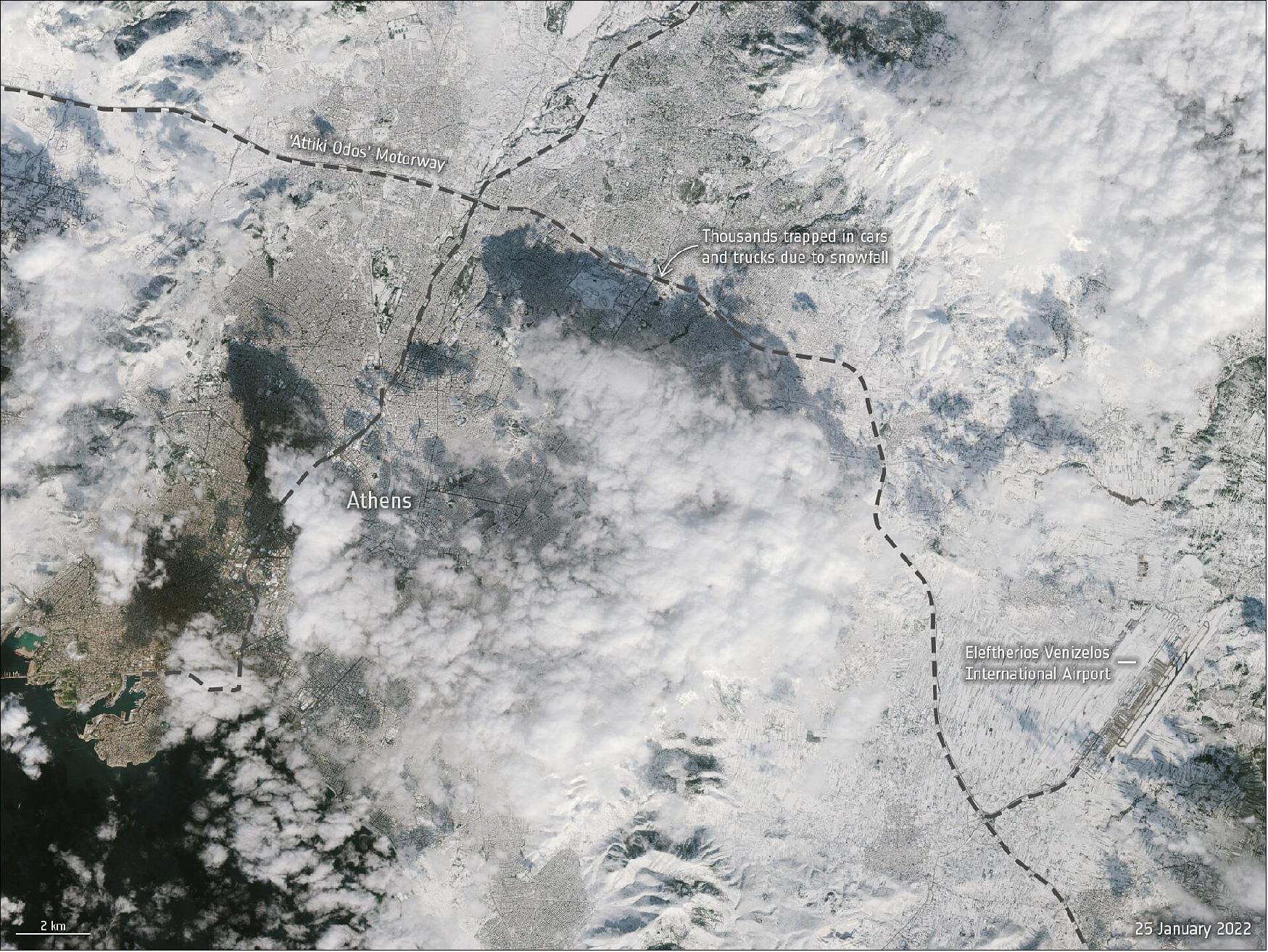
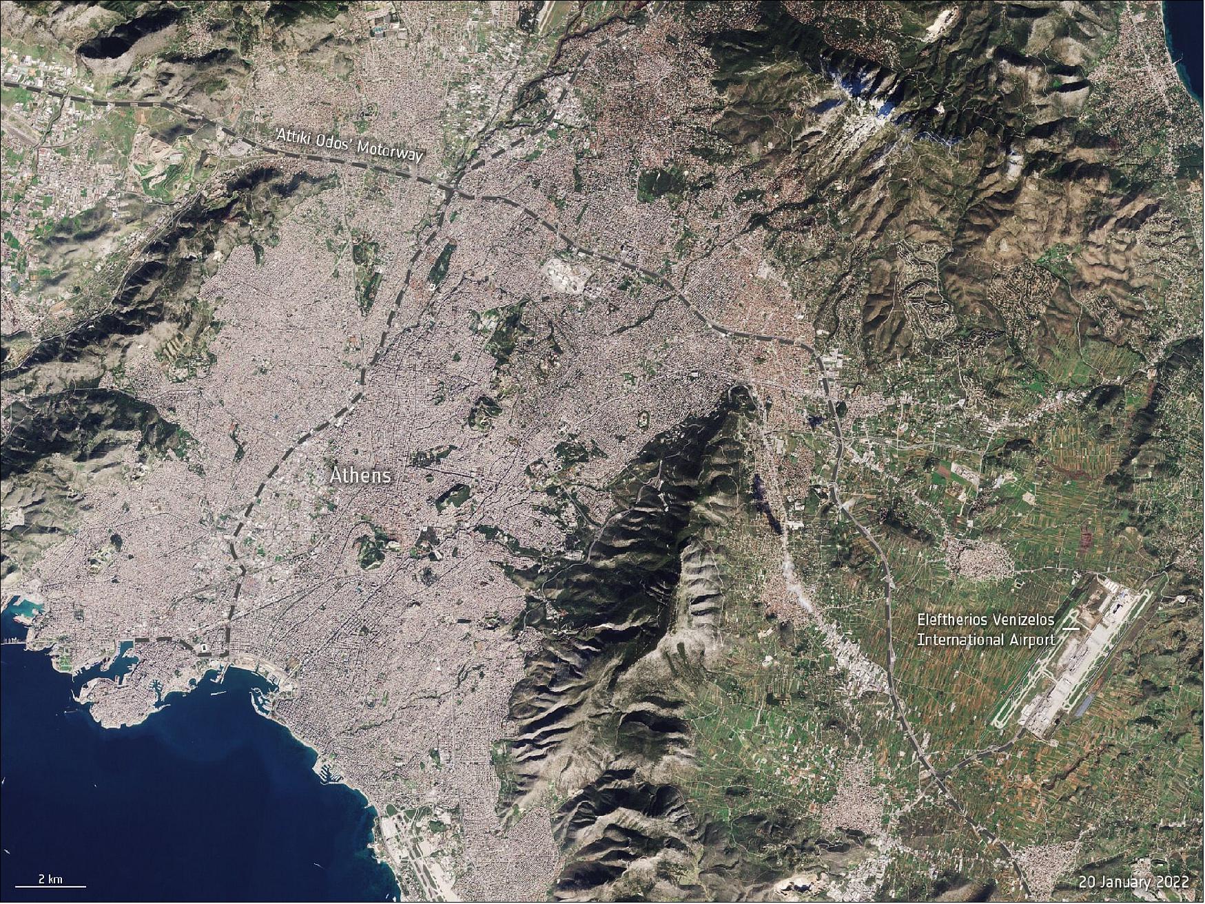
• January 26, 2022: An unusual snowstorm has blanketed parts of Turkey and Greece, causing power cuts and chaos on the roads and flight cancellations. These two satellite images, from the Copernicus Sentinel-2 mission, show Athens: the image of Figure 2 was captured on 25 January and the image of Figure 3 is from 20 January. 2)
• January 28, 2022: The Copernicus Sentinel-2 mission takes us over northwest Lesotho – a small, land-locked country surrounded entirely by South Africa 3). The country’s agricultural system faces a growing number of issues, including a small portion of the land deemed arable, as well as other climate-related vulnerabilities such as drought, floods and extreme temperatures occurring more frequently.
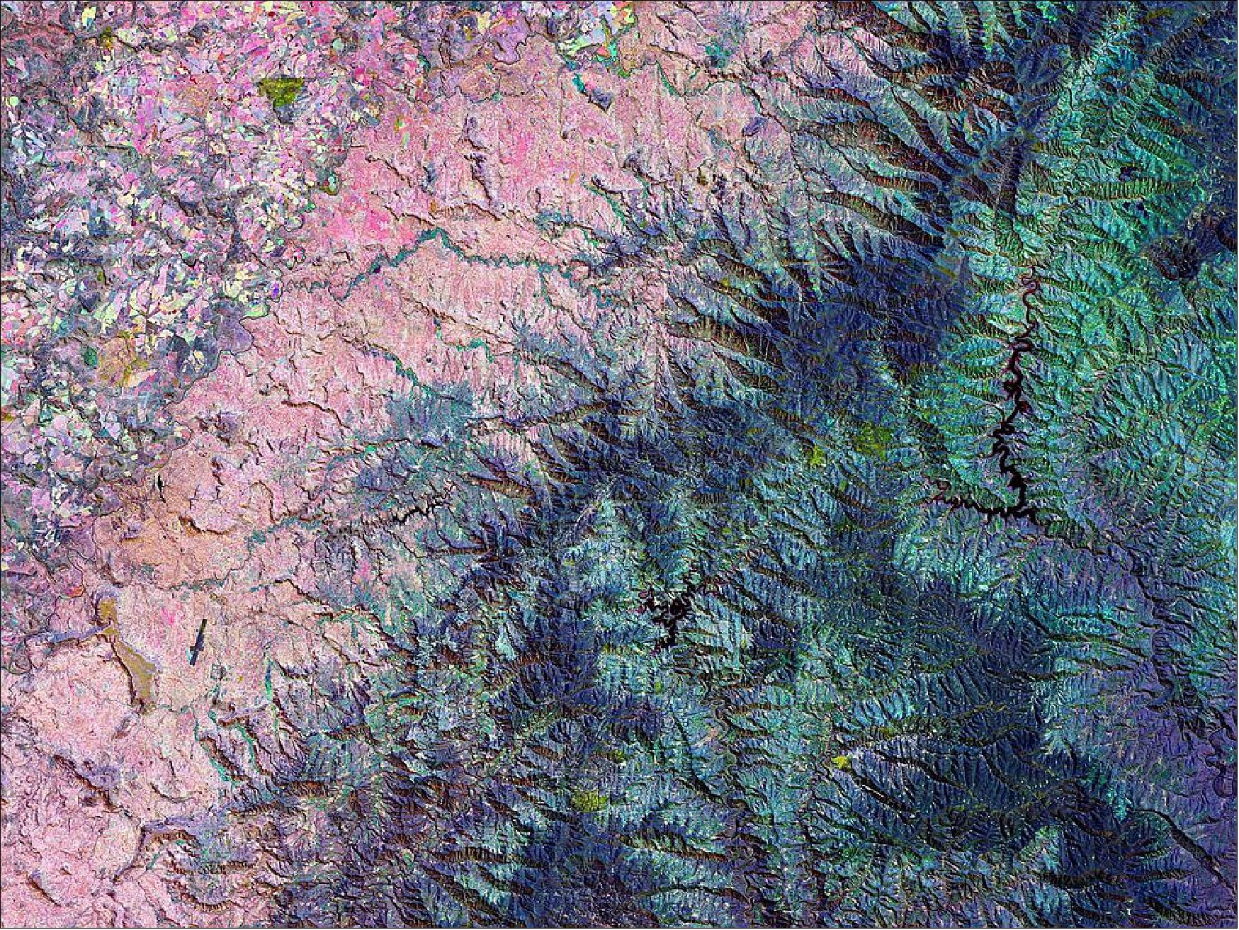
- All other colours visible in the image are different mixtures of red, green and blue, and vary according to the stage of vegetation growth. A distinct pattern emerges due to topographical differences in this mountainous landscape. The Copernicus Sentinel-2 mission’s revisit time of just five days, along with the mission’s range of spectral bands, means that changes in plant health and growth can be more easily monitored.
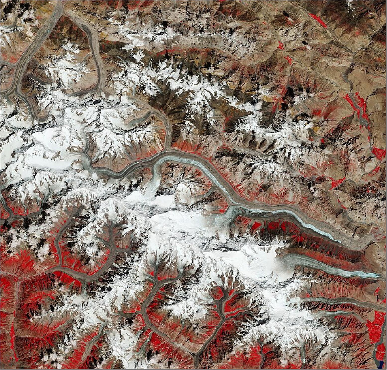
• February 4, 2022: The Copernicus Sentinel-2 mission takes us over Batura Glacier – one of the largest and longest glaciers in the world, outside of the polar regions. 4) Glacier shrinkage is a prominent sign of ongoing climate change. However, unlike many glaciers around the world, the glaciers residing in the mountain ranges in Karakoram are not responding to global warming. Their retreating is less than the global average, and in some cases, are either stable or growing. Satellites can help monitor changes in glacier mass, extents, trace area and length of glacier changes through time and derive surface velocity. Learn more about how Copernicus Sentinel-2 can help enhance glacier monitoring.
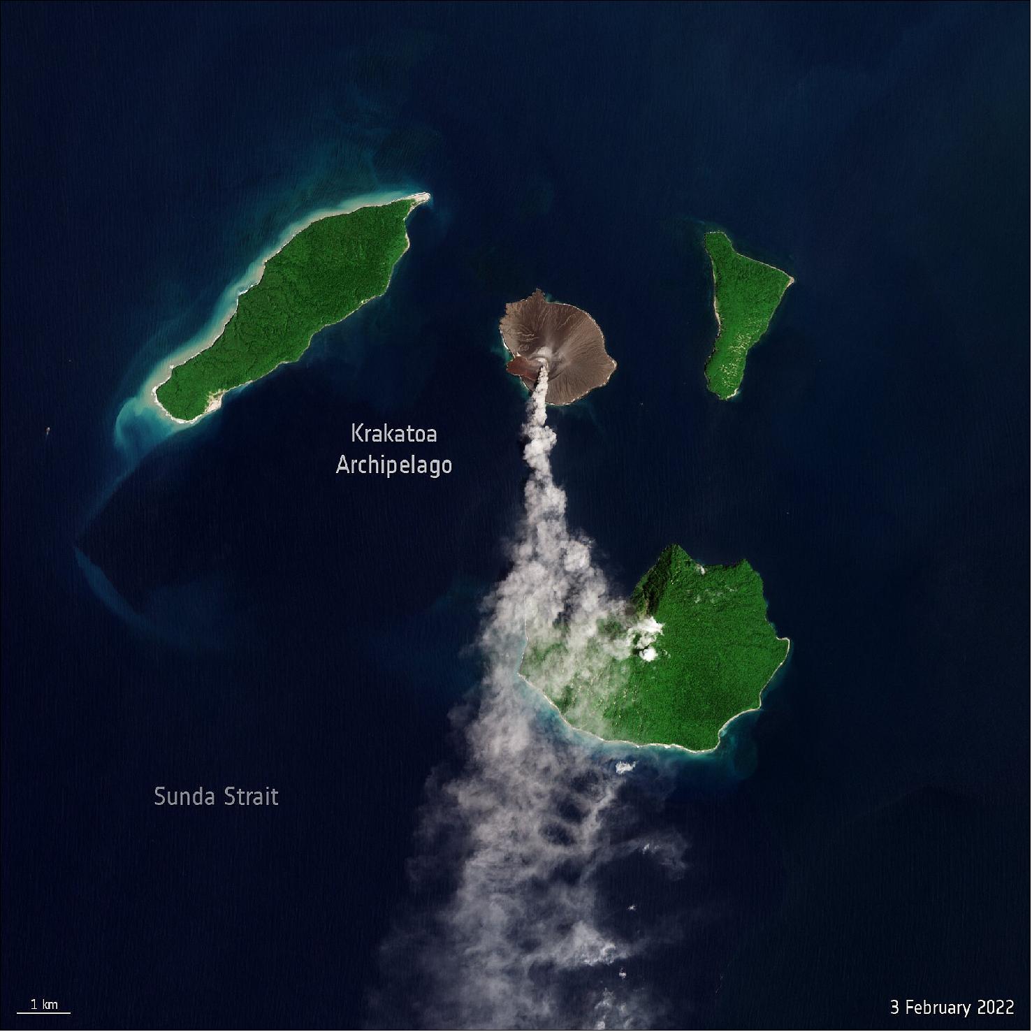
• February 4, 2022: New eruption at Krakatoa Volcano. 5)
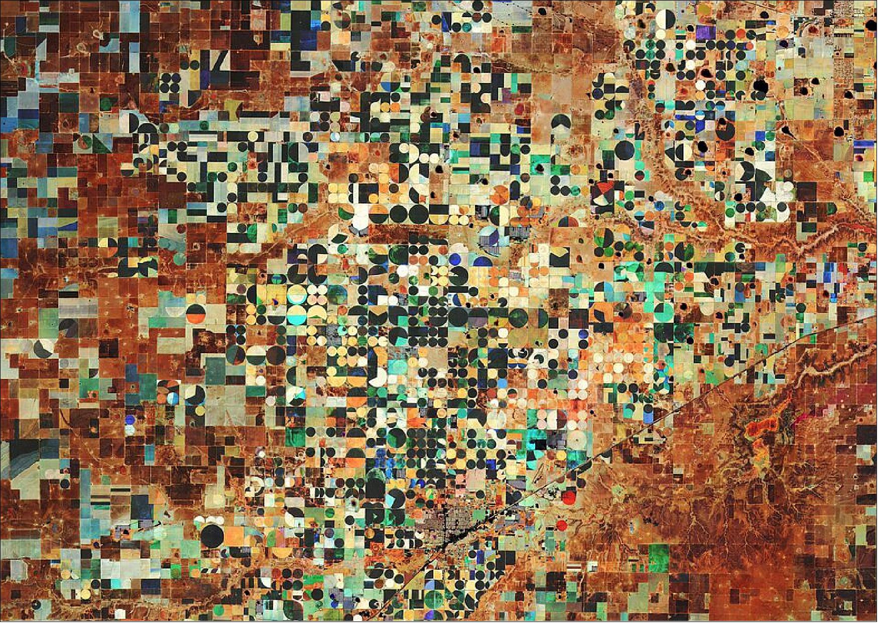
• February 11, 2022: Hereford, which is the county seat of Deaf Smith County in Texas, is widely known for its agriculture industry 6). Circular shapes in the image are an example of centre-pivot irrigation systems, where equipment rotates around a central pivot and crops are watered with sprinklers. This type of irrigation helps farmers manage their watering demands as well as help conserve their precious water sources.
- Shades of red, yellow and green depict changes in vegetation growth at the beginning of the season. Black patches of land indicate very low vegetation for the season, while white signifies a high level of vegetation during these dates. The Normalised Difference Vegetation Index is widely used in remote sensing as it gives scientists an accurate measure of health and status of plant growth.
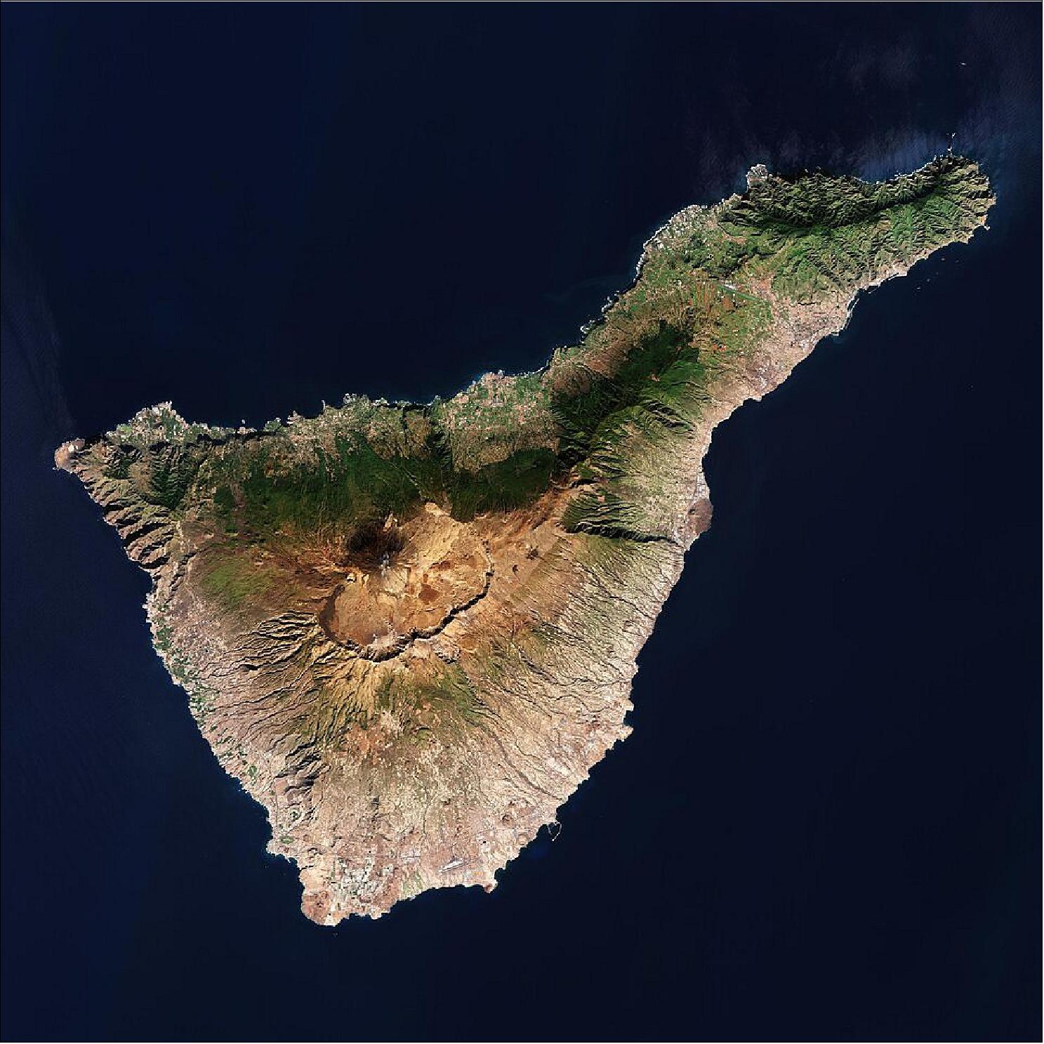
• February 18, 2022: The Copernicus Sentinel-2 mission takes us over Tenerife – the largest of Spain’s Canary Islands 7). Tenerife's weather and climate are heavily influenced by the trade winds blowing from the northeast for most of the year, bringing humidity and precipitation to the north of the island, as well as to the northern slopes of Mount Teide. This effect can be clearly seen in the dark green colours in the image showing vegetation cover.
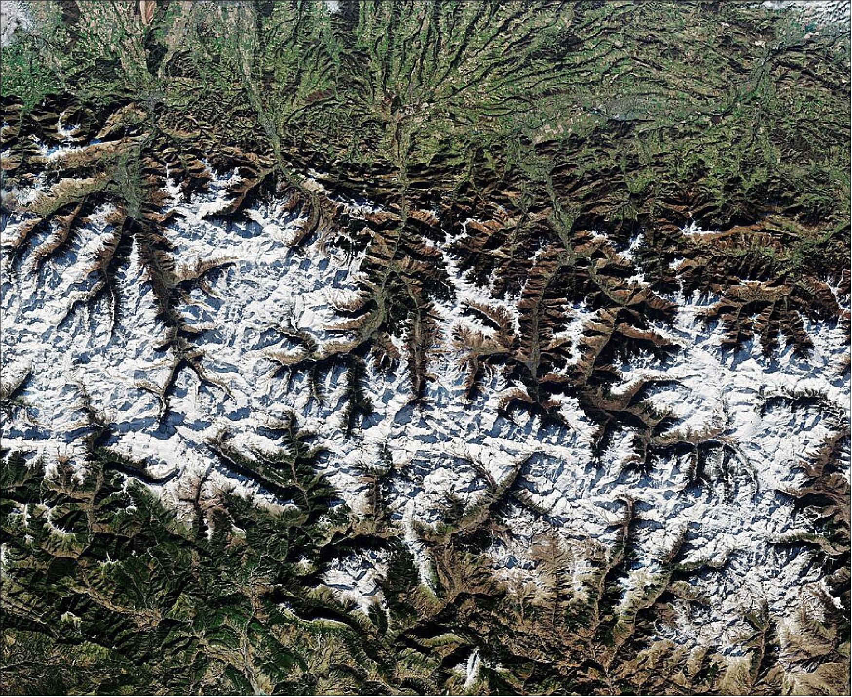
• March 4, 2022: Today, the Copernicus Sentinel-2 mission takes us over the Pyrenees Mountains in southwest Europe. The mountain range forms a natural border between France and Spain with the small, landlocked country of Andorra sandwiched in between 8). The Copernicus Sentinel-2 mission is designed to play a key role in mapping differences in land cover to understand the landscape, map how it is used and monitor changes over time.
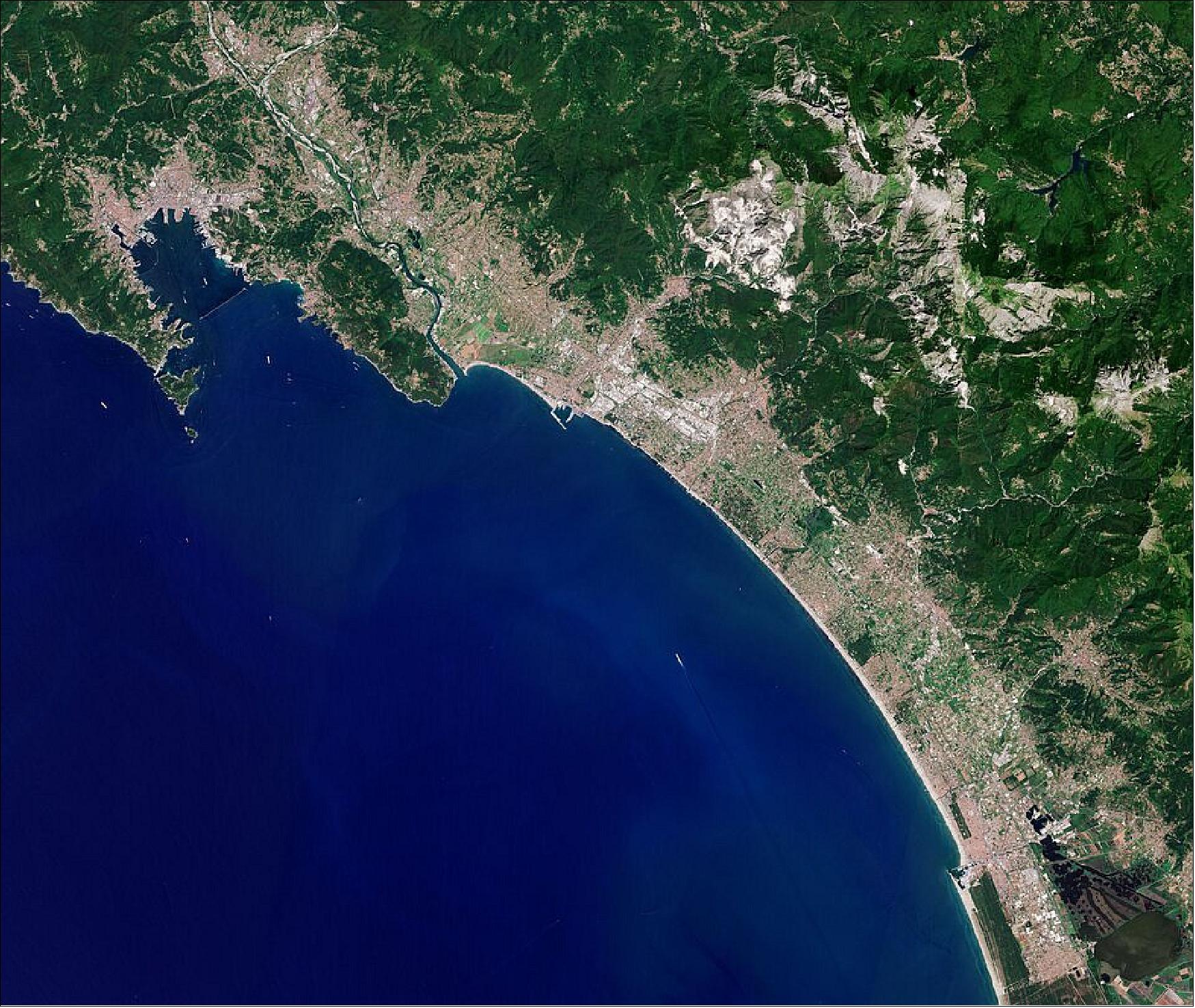
• March 25, 2022: The Copernicus Sentinel-2 mission takes us over Carrara – an Italian city known especially for its world-famous marble, visiblejust above the centre of the image 9). What appears as snow cover on the rugged mountains is actually bright white marble, contrasting with Tuscany’s lush green vegetation. Also featured in this summery image from Sentinel-2 are the towns of Forte dei Marmi, Pietrasanta, Lido di Camaiore and Viareggio.
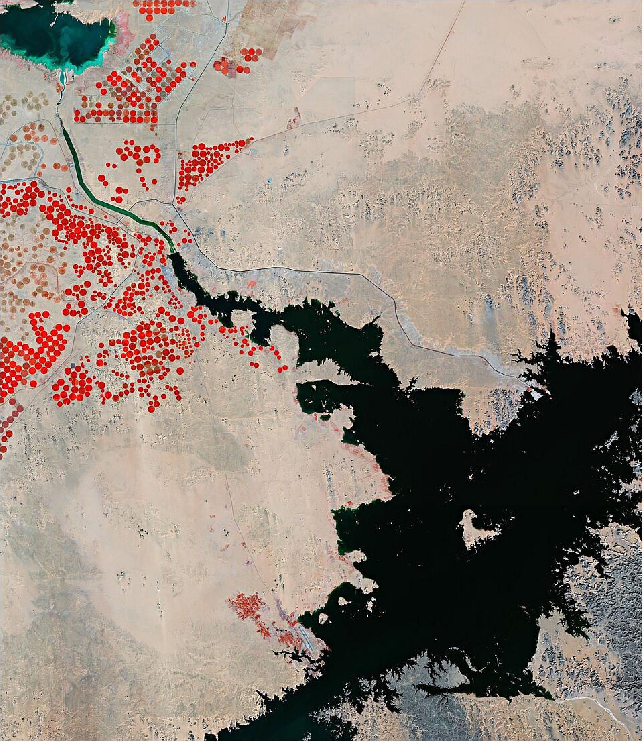
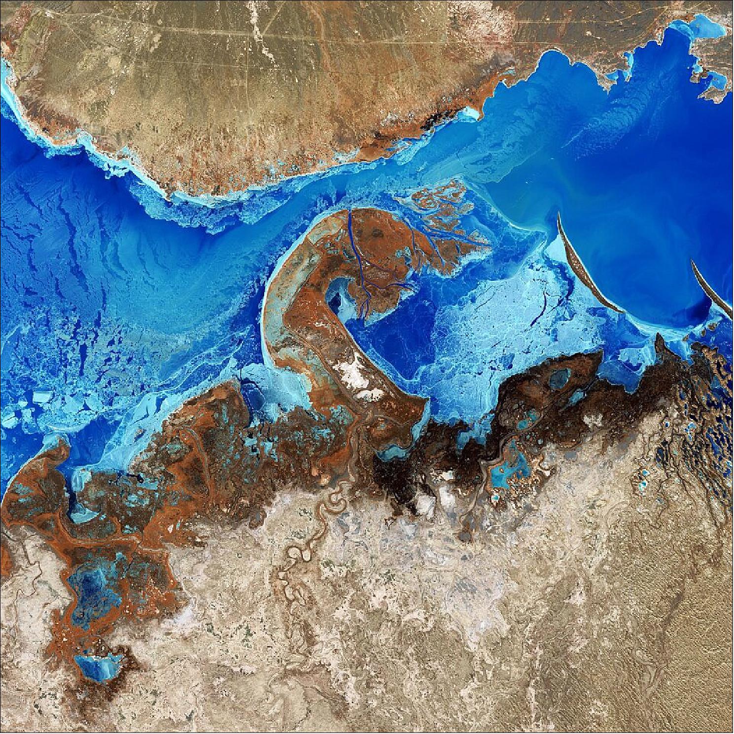
• March 18, 2022: Lake Nasser, visible in the lower-right in black, is a vast lake and reservoir located in southern Egypt and northern Sudan. The lake was created as a result of the construction of the Aswan High Dam across the waters of the Nile in the late-1960s. This ambitious project was designed to provide irrigation to new agricultural developments and attract people to the region. 10)
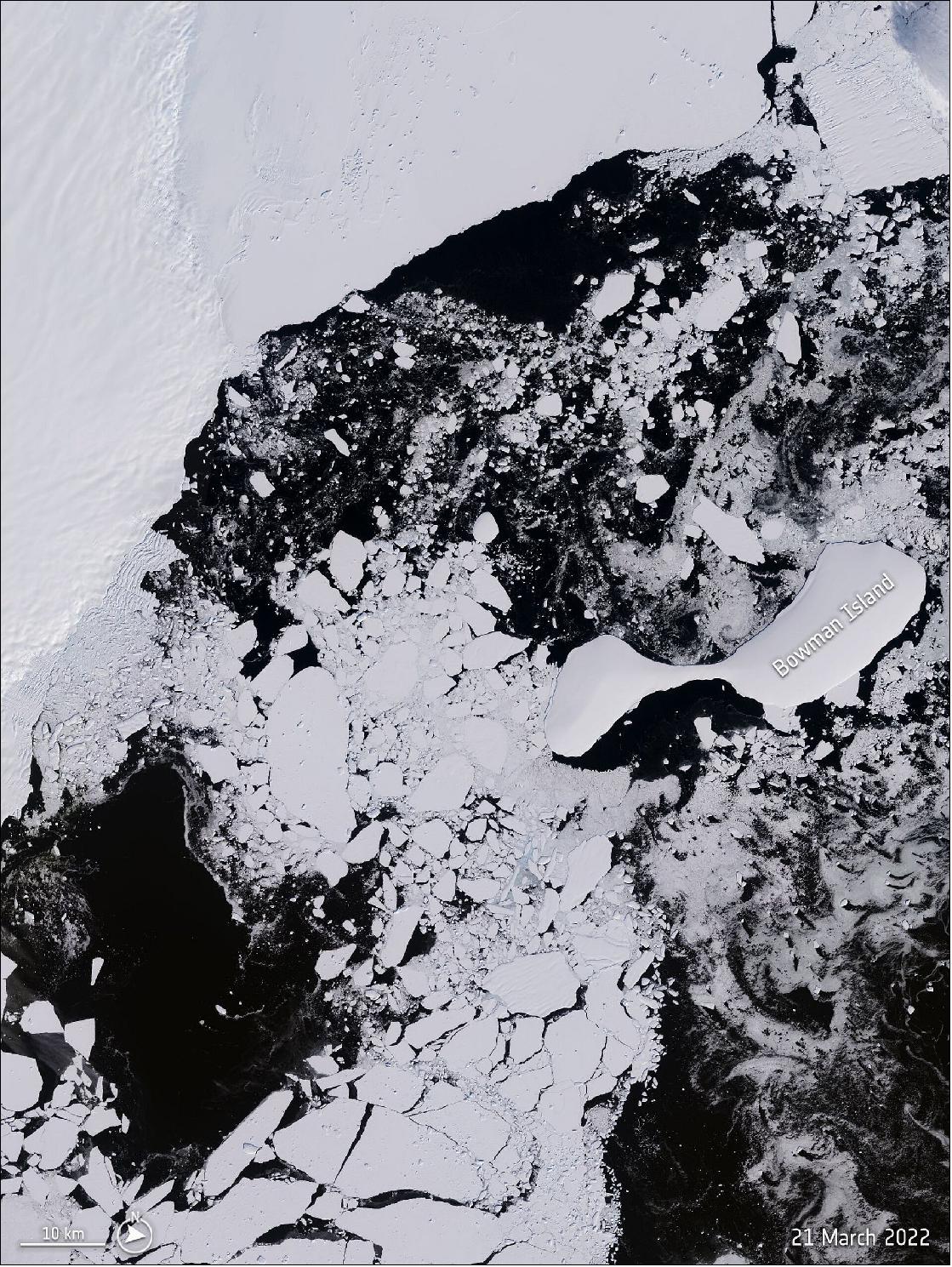
• March 30, 2022: Spotted by the Copernicus Sentinel-2 mission, the Conger ice shelf collapsed in East Antarctica around 15 March. 11)
• April 01, 2022: Barranquilla, the capital of the Atlántico department in northwest Colombia, is featured in this image taken by the Copernicus Sentinel-2 mission 12). The urban area of Barranquilla, with airport runways visible south of the city, contrasts with the Ciénaga Grande de Santa Marta swampy marshes to the east visible in dark green.
Other notable features in the image include the El Guajaro Reservoir, around 50 km southwest of Barranquilla. In addition to sewage discharges, the reservoir receives agricultural runoff, which leads to blooms of harmful microorganisms, otherwise known as cyanobacteria. These types of algae are most likely why the lake appears in emerald green in today’s image. Satellite data from the Copernicus Sentinel-2 mission can track the growth and spread of harmful algae blooms in order to alert and mitigate against damaging impacts for tourism and fishing industries.
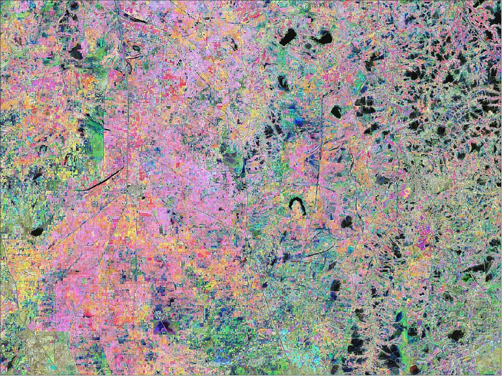
• April 8, 2022: The Copernicus Sentinel-2 mission takes us over part of Sindh – the third-largest province of Pakistan 13). The colourful image was created by combining three separate images from the near-infrared channel from the Copernicus Sentinel-2 mission. The Copernicus Sentinel-2 mission is specifically designed to provide images that can be used to distinguish between crop types as well as data on numerous plant indices, such as leaf area index, leaf chlorophyll content and leaf water content – all of which are essential to accurately monitor plant growth.
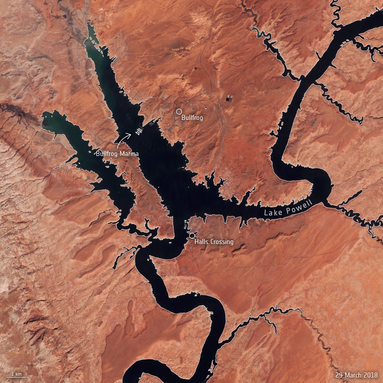
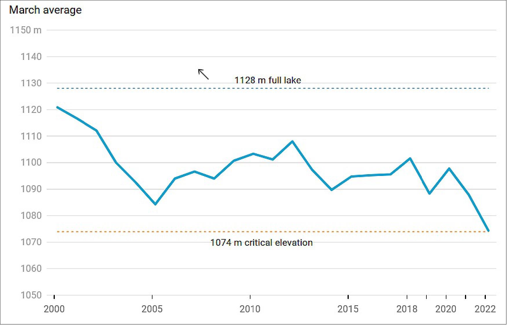
• April 11, 2022: After decades of drought, water levels in Lake Powell, the second-largest humanmade reservoir in the United States, have shrunk to its lowest level since it was created more than 50 years ago, threatening millions of people who rely on its water supply 14). In mid-March 2022, Lake Powell’s elevation dropped to an astonishing 1074 m above sea level – the lowest the lake has been since it was filled in 1980. This drastic drop in water levels is documented in natural-colour images captured by the Copernicus Sentinel-2 mission.
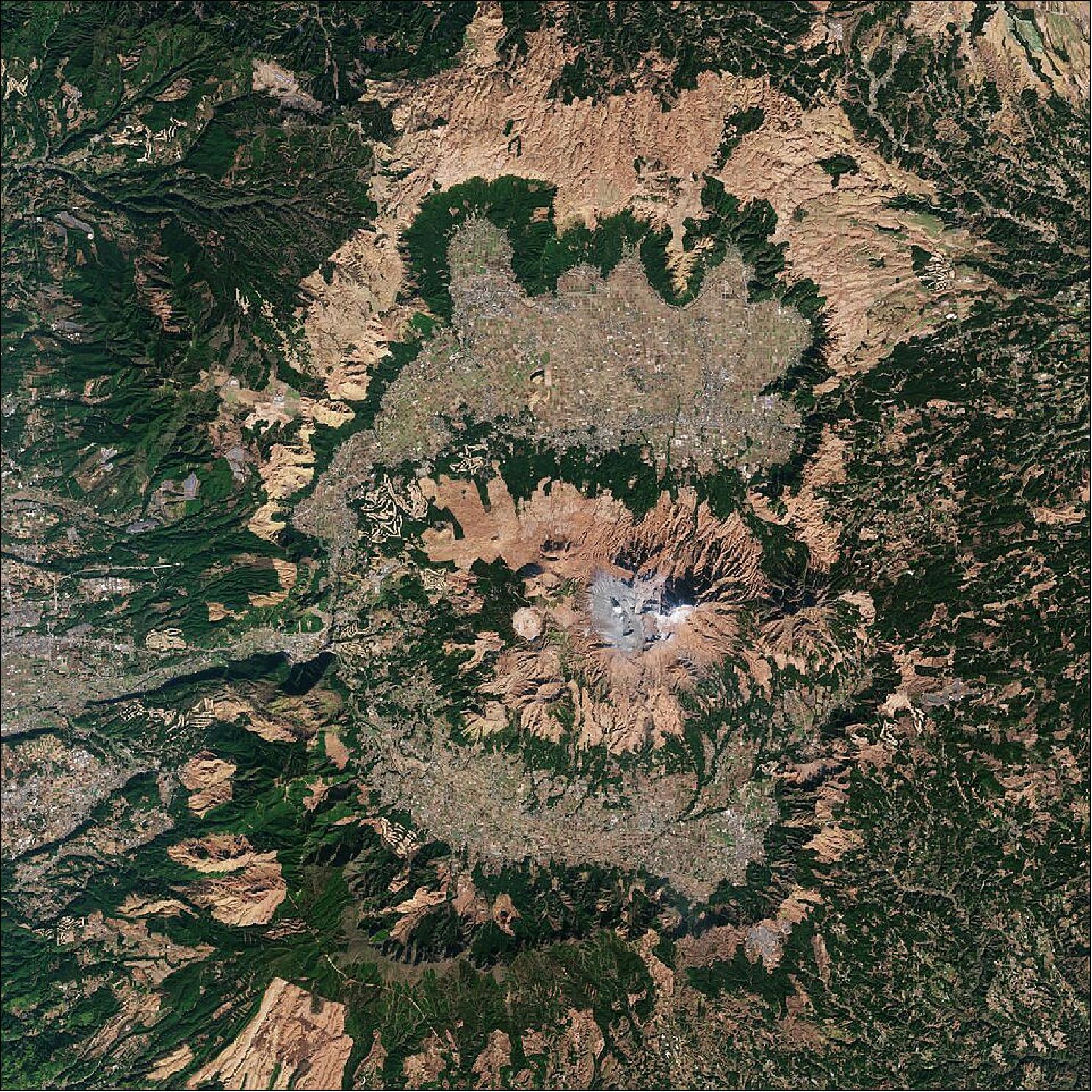
• April 29, 2022: Mount Aso, the largest active volcano in Japan, is featured in this image captured by the Copernicus Sentinel-2 mission 15). Satellite data can be used to detect the slight signs of change that may foretell an eruption. Once an eruption begins, optical and radar instruments can capture the various phenomena associated with it, including lava flows, mudslides, ground fissures and earthquakes. Atmospheric sensors on satellites can also identify the gases and aerosols released by the eruption, as well as quantify their wider environmental impact.
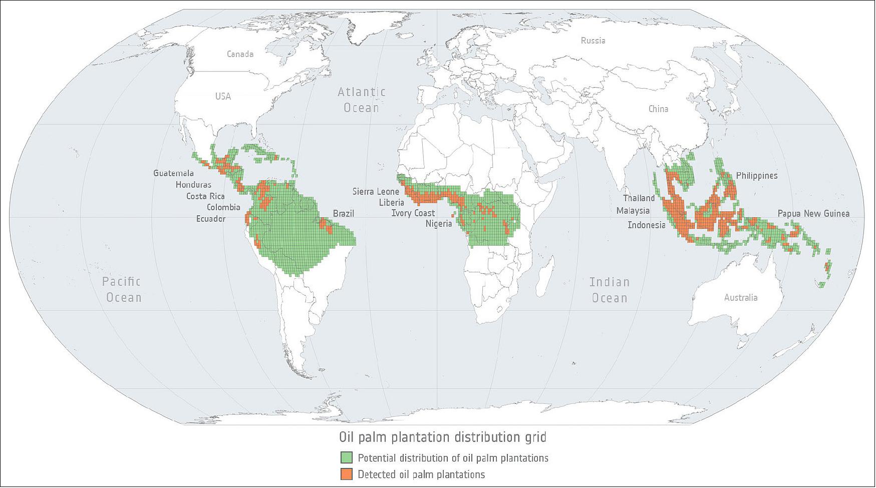
• May 05, 2022: The global trade in agricultural commodities provides food, fuel and fibre to consumers around the world. Commodity production, however, is also linked with negative environmental impacts, including the loss and degradation of forested land. 16)
In a new study published in Science Advances, a team of scientists from Europe and the US, combined detailed shipping data from Trase with corporate disclosures, farm-level production and remote sensing data to better understand how commodity traders source products on the ground, and how this affects the implementation of corporate zero-deforestation commitments 17). Findings to support this article partially come from a recently published study in Science Direct, where the authors identified cocoa plantations in both Ivory Coast and Ghana using satellite data from the Copernicus programme. The team were able to detect cocoa plantations thanks to Sentinel-1’s radar data combined with Sentinel-2’s optical imagery in a big data cloud-computing environment. 18)
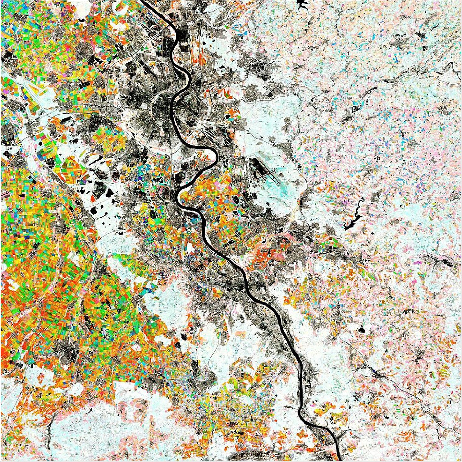
• May 6, 2022: The Rhine River, the longest river in Germany, is featured in this colourful image captured by the Copernicus Sentinel-2 mission 19). Each colour in this week’s image represents the average NDVI value of an entire season between 2018 and 2021. Shades of red depict peak vegetation growth in April and May, green shows changes in June and July, while blue shows August and September. Colourful squares, particularly visible in the left of the image, show different crop types.
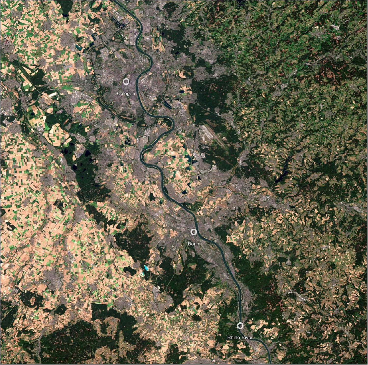
• May 20, 2022: Bonn, one of the oldest cities in Germany, can be seen straddling the Rhine River in the lower half of the image, around 24 km south of Cologne 20). Along the river lies one of the most modern congress centres in Europe: the World Conference Center Bonn. It is here where ESA’s Living Planet Symposium 2022 will take place.
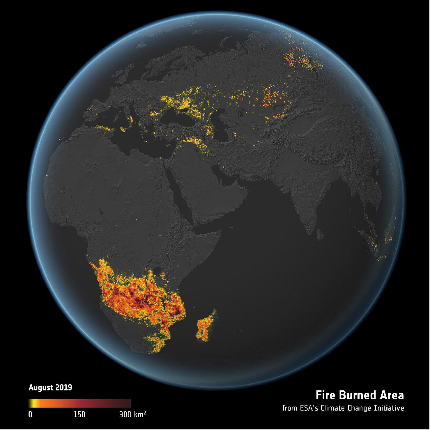
• May 24, 2022: Today, at ESA’s Living Planet Symposium, much of the focus was on furthering the uptake of Earth observation and advancing the digital transformation in Africa to address societal challenges. The free and open access to data and services has allowed African institutions to develop applications to monitor water quality in lakes, prepare adaptation measures for agriculture and to monitor biodiversity, for example. 21)
Optical data from the Copernicus Sentinel-2 mission have shown that the area of land across the whole continent affected by fire is 80% bigger than previously thought. Satellite data showing burned ground not only reveal damage from wildfires, but also where slash and burn practices have taken place.
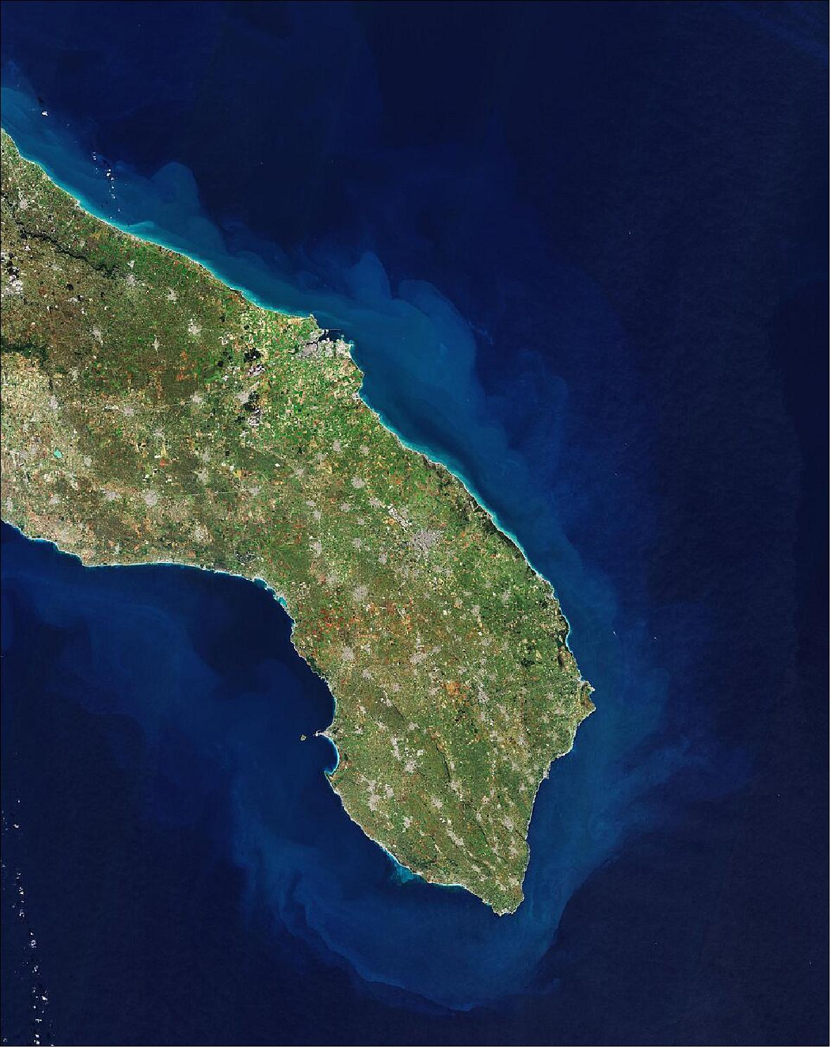
• June 3, 2022: Puglia (Apulia), the heel of the boot-shaped country, has the longest coastline of any Italian mainland region. Covering almost 20,000 km2, it is Italy’s seventh largest region and its coastline, dotted with some of Italy’s finest sandy beaches and azure seas, runs for around 800 km 22). As well as providing detailed information about Earth’s vegetation, the Copernicus Sentinel-2 mission is designed to play a key role in mapping differences in land cover to understand the landscape, map how it is used and monitor changes over time.
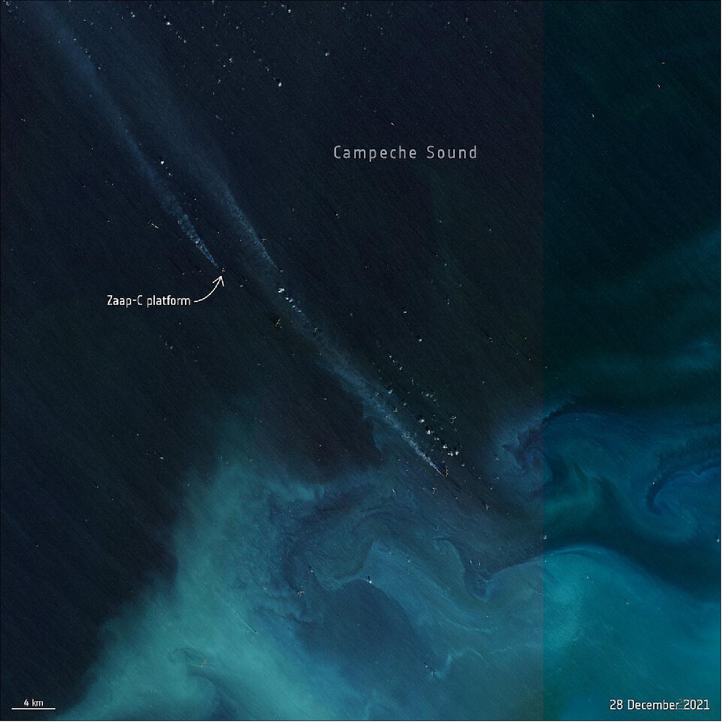
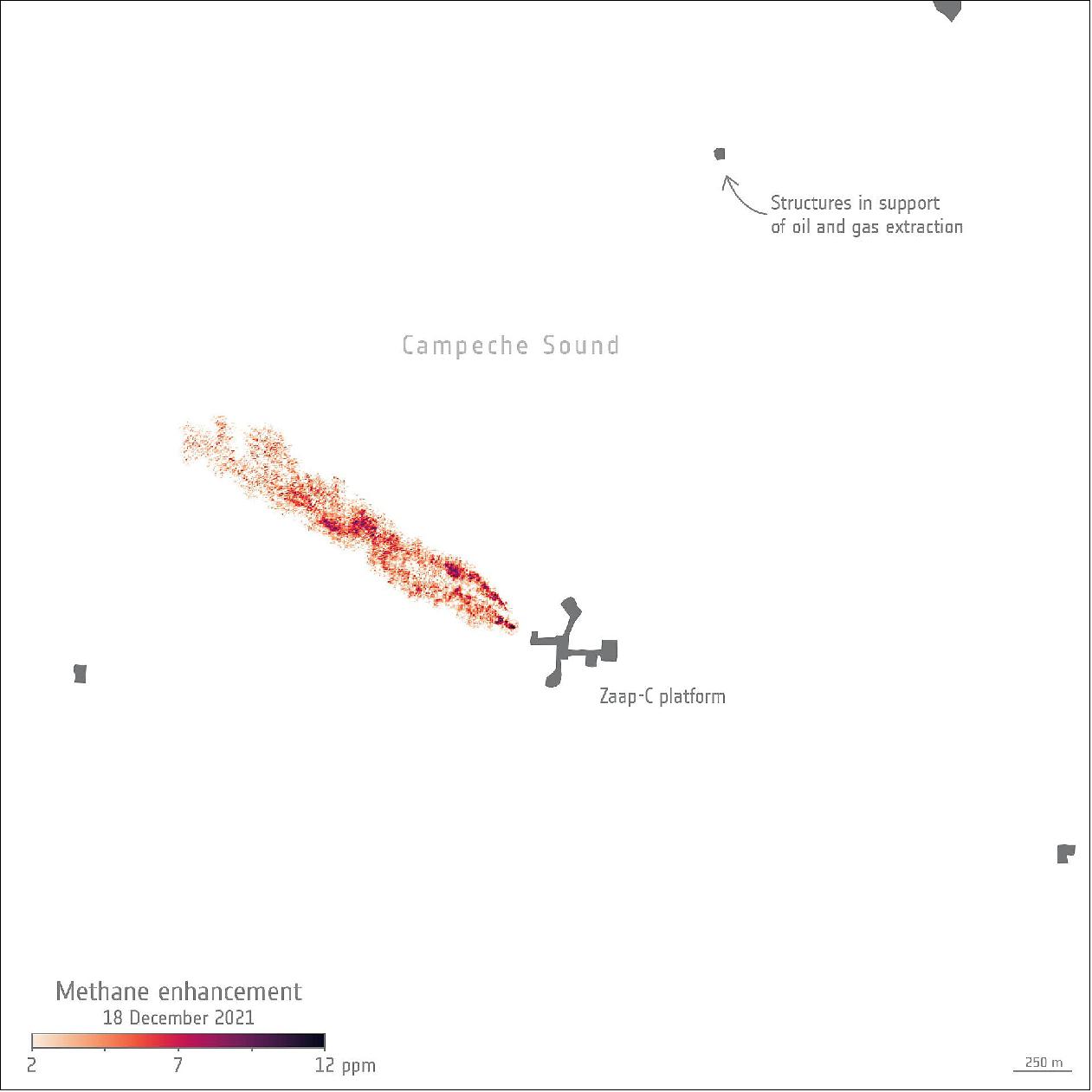
• June 9, 2022: A team of scientists have used satellite data to detect methane plumes from an offshore platform in the Gulf of Mexico. This is the first time that individual methane plumes from offshore platforms are mapped from space 23). Luis Guanter, from the Valencia Polytechnic University, commented, “The results here demonstrate how satellites can detect methane plumes from offshore infrastructure. This represents a breakthrough in the monitoring of industrial methane emissions from space, as it opens the door to systematic monitoring of emissions from individual offshore platforms.”
• June 17, 2022: Part of the Glacier Bay National Park and Preserve, which lies along the coast of southeast Alaska, is featured in this image captured by the Copernicus Sentinel-2 mission 24). Muir Glacier, formerly the most famous of the tidewater glaciers, once rose around 80 m above water and was nearly 3 km wide but has now shrunk and receded and no longer reaches the sea. Glacier Bay is just one of the many areas suffering from the effects of global warming.
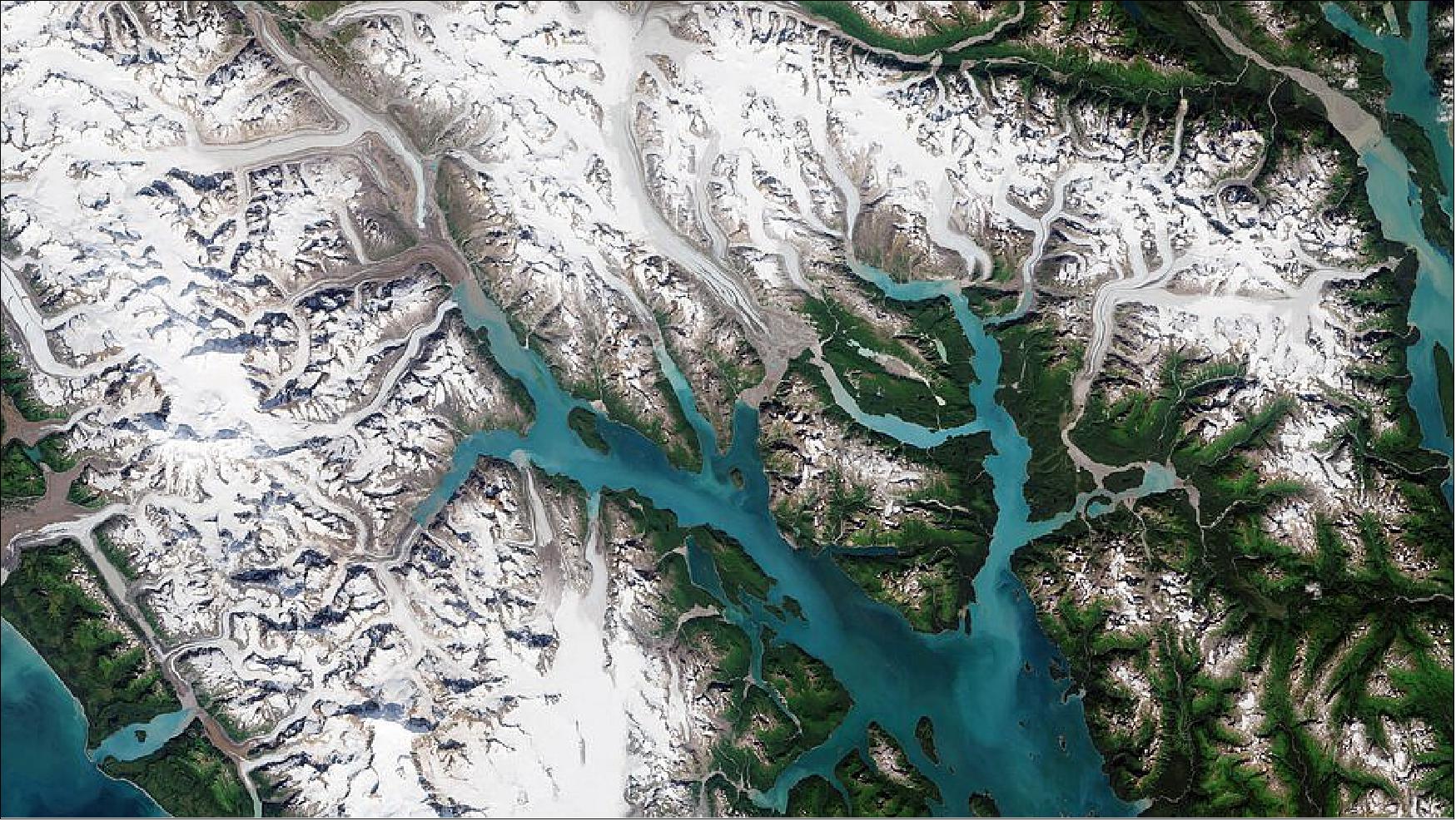
- The exhibition focuses on the world’s largest mountain glaciers with 90 photographic comparisons displayed alongside scientific data collected during the team’s expedition to the world’s largest mountain glaciers. More information on the exhibition, which is part of a scientific collaboration between ESA and is sponsored by UNESCO, can be found here.
• June 24, 2022: Lake Balkhash, the largest lake in Central Asia, is featured in this false-colour image captured by the Copernicus Sentinel-2 mission 25). The two parts of the lake are united by a narrow strait, the Uzynaral visible in the centre of the image, with a depth of around 6 m. The sediment plume passing through the Uzynaral Strait is most likely due to waves stirring up sediments from the bottom of the lake. This has led to a higher reflection and thus a brighter water colour in this part of the lake.
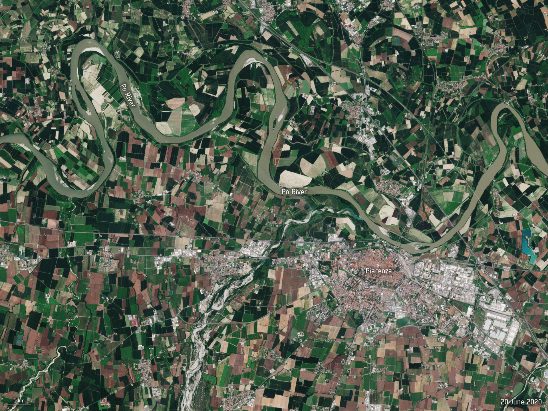
• June 27, 2022: The Po River, the longest river in Italy, is hitting record low water levels after months without heavy rainfall. This Copernicus Sentinel-2 animation shows a part of the Po Valley, near Piacenza, and reveals how the river has significantly shrunk between June 2020 and June 2022, (26). The river is used for drinking water, nourishing vast swathes of agricultural land, as well as producing hydroelectric power across northern Italy.
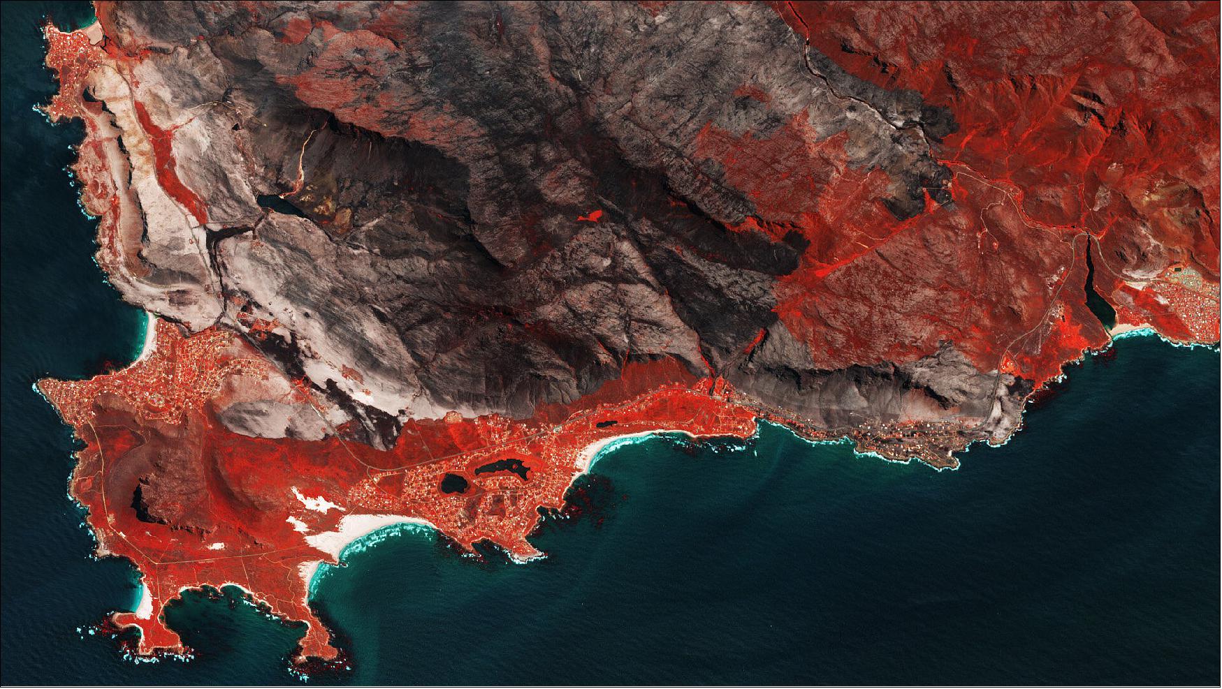
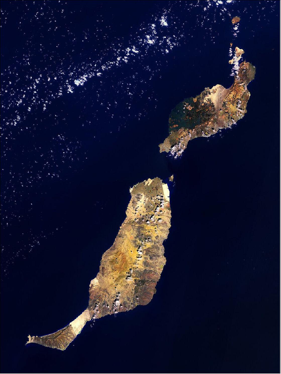
• July 8, 2022: Fuerteventura and Lanzarote, part of the Canary Islands lying in the North Atlantic Ocean, are featured in this false-colour image captured by the Copernicus Sentinel-2 mission 26). Lanzarote has a long history of eruptions and is often referred to as the ‘Island of the 1000 volcanoes’, yet it is actually the least mountainous Canarian Island. Fuerteventura is the oldest island in the Canary Archipelago, having risen between 12 and 20 million years ago owing largely to volcanic activity. 27)
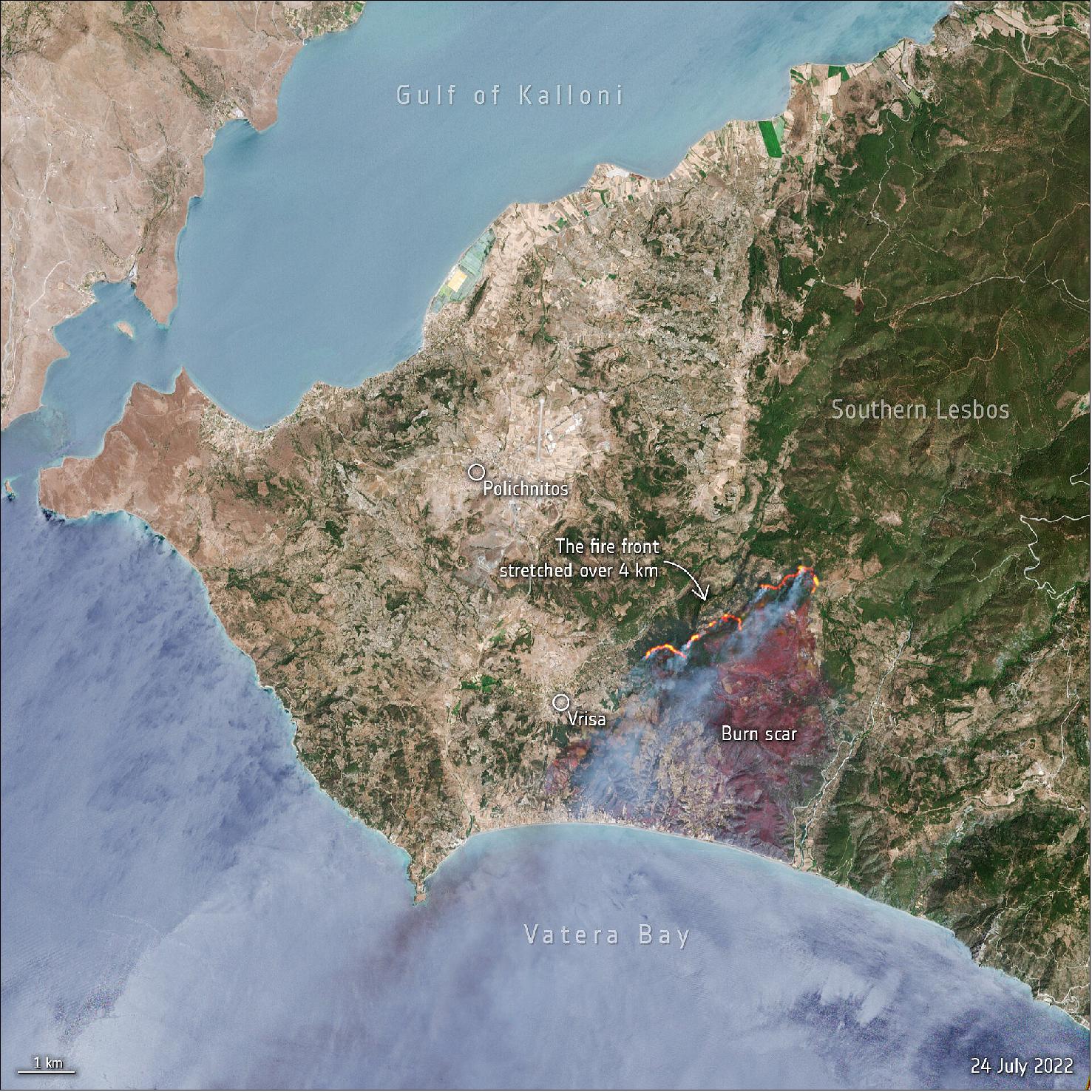
• July 25, 2022: Hundreds of residents and tourists have been evacuated from the east Aegean island of Lesbos (also known as Lesvos), Greece, after a wildfire broke out on the morning of 23 July. The fire, which has been raging near the coastal area of Vatera, a popular tourist destination, has burned pine forest, shrubland and cultivated fields. 28)
References
1) ”Mecklenburg–West Pomerania, Germany,” ESA Applications, 21 January 2022, URL: https://www.esa.int/Applications/Observing_the_Earth/Copernicus/Earth_from_Space_Mecklenburg_West_Pomerania_Germany
2) ”Athens under snow,” ESA Applications, 26 January 2022, URL: https://www.esa.int/ESA_Multimedia/Images/2022/01/Athens_under_snow
3) ”Earth from Space: Lesotho,” ESA Applications, 28 January 2022, URL: https://www.esa.int/Applications/Observing_the_Earth/Copernicus/Earth_from_Space_Lesotho
4) ”Earth from Space: Batura Glacier,” ESA Applications, 4 February 2022, URL: https://www.esa.int/Applications/Observing_the_Earth/Copernicus/Earth_from_Space_Batura_Glacier
5) ”New eruption at Krakatoa Volcano,” ESA Applications, 4 February 2022, URL: https://www.esa.int/About_Us/Week_in_images/Week_in_images_31_January_-_4_February_2022
6) ”Earth from Space: Hereford, Texas,” ESA Applications, 11 February 2022, URL: https://www.esa.int/Applications/Observing_the_Earth/Copernicus/Earth_from_Space_Hereford_Texas
7) ”Earth from Space: Tenerife, Canary Islands,” ESA Applications, 18 February 2022, URL: https://www.esa.int/Applications/Observing_the_Earth/Copernicus/Earth_from_Space_Tenerife_Canary_Islands
8) ”Earth from Space: Snowy Pyrenees,” ESA Applications, 4 March 2022, URL: https://www.esa.int/Applications/Observing_the_Earth/Copernicus/Earth_from_Space_Snowy_Pyrenees
9) ”Earth from Space: Lake Nasser, Egypt,” ESA Applications, 18 March 2022, URL: https://www.esa.int/Applications/Observing_the_Earth/Copernicus/Earth_from_Space_Lake_Nasser_Egypt
10) ”Earth from Space: Carrara, Italy,” ESA Applications, 25 March 2022, URL: https://www.esa.int/Applications/Observing_the_Earth/Copernicus/Earth_from_Space_Carrara_Italy
11) ”Conger ice shelf collapses,” ESA Applications, 30 March, 2022, URL: https://www.esa.int/About_Us/Week_in_images/Week_in_images_28_March_-_1_April_2022
12) ”Earth from Space: Barranquilla, Colombia,” ESA Applications, 01 April 2022, URL: https://www.esa.int/Applications/Observing_the_Earth/Copernicus/Earth_from_Space_Barranquilla_Colombia
13) ”Earth from Space: Sindh, Pakistan,” ESA Applications, 08 April 2022, URL: https://www.esa.int/Applications/Observing_the_Earth/Copernicus/Earth_from_Space_Sindh_Pakistan
14) ”Dwindling water levels of Lake Powell seen from space,” ESA Applications, 11 April 2022, URL: https://www.esa.int/Applications/Observing_the_Earth/Copernicus/Sentinel-2/Dwindling_water_levels_of_Lake_Powell_seen_from_space
15) ”Earth from Space: Mount Aso, Japan,” ESA Applications, 29 April 2022, URL: https://www.esa.int/Applications/Observing_the_Earth/Copernicus/Earth_from_Space_Mount_Aso_Japan
16) Itohan-OsaAbua, Zoltan Szantoi, Andreas Brink,Marine Robuchon,Michael Thiel, ”Detecting cocoa plantations in Côte d’Ivoire and Ghana and their implications on protected areas,” Science Direct, Volume 129, October 2021, 107863, https://doi.org/10.1016/j.ecolind.2021.107863
17) Erasmus K. H. J. zu Ermgassen, Mairon G. Bastos Lima, Helen BellfieldAdeline Dontenville, Toby Gardner, Javier Godar, Robert Heilmayr, Rosa Indenbaum, Tiago N. P. dos Reis, Vivian RibeiroItohan-osa AbuZoltan Szantoi, and Patrick Meyfroidt, ”Addressing indirect sourcing in zero deforestation commodity supply chains,” Science Advances, Vol. 8, Issue 17, Published: 29 April 2022, https://www.science.org/doi/10.1126/sciadv.abn3132
18) ”Tracking agricultural-related deforestation,” ESA Applications, 05 May 2022, URL: https://www.esa.int/Applications/Observing_the_Earth/Tracking_agricultural-related_deforestation
19) ”Earth from Space: Rhine River, Germany,” ESA Applications, 06 May 2022, URL: https://www.esa.int/Applications/Observing_the_Earth/Copernicus/Earth_from_Space_Rhine_River_Germany
20) ”Bonn, Germany,” ESA Applications, 20 May 2022, URL: https://www.esa.int/Applications/Observing_the_Earth/Copernicus/Earth_from_Space_Bonn_Germany
21) ”Africa in the spotlight at Living Planet Symposium,” ESA Applications, 24 May 2022, URL: https://www.esa.int/Applications/Observing_the_Earth/FutureEO/Africa_in_the_spotlight_at_Living_Planet_Symposium
22) ”Earth from Space: Puglia, Italy,” ESA Applications, 3 June 2022, URL: https://www.esa.int/Applications/Observing_the_Earth/Copernicus/Earth_from_Space_Puglia_Italy
23) ”Methane emissions detected over offshore platform in the Gulf of Mexico,” ESA Applications, 9 June 2022, URL: https://www.esa.int/Applications/Observing_the_Earth/Methane_emissions_detected_over_offshore_platform_in_the_Gulf_of_Mexico
24) ”Earth from Space: Glacier Bay, Alaska,” ESA Applications, 17 June 2022, URL: https://www.esa.int/Applications/Observing_the_Earth/Copernicus/Earth_from_Space_Glacier_Bay_Alaska
25) ”Earth from Space: Lake Balkhash,” ESA Applications, 24 June 2022, URL: https://www.esa.int/Applications/Observing_the_Earth/Copernicus/Earth_from_Space_Lake_Balkhash
26) ”Po River dries up,” ESA Applications, 27 June 2022, URL: https://www.esa.int/ESA_Multimedia/Images/2022/06/Po_River_dries_up
27) ”Earth from Space: Fuerteventura and Lanzarote,” ESA Applications, 8 July 2022, URL: https://www.esa.int/Applications/Observing_the_Earth/Copernicus/Earth_from_Space_Fuerteventura_and_Lanzarote
28) ”Greece battles wildfires on Lesbos island,” ESA Applications, 25 July 2022, URL: https://www.esa.int/ESA_Multimedia/Images/2022/07/Greece_battles_wildfires_on_Lesbos_island