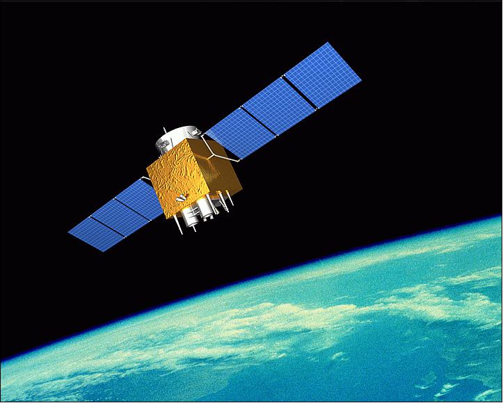
GF-1 (Gaofen-1)
EO
Imaging multi-spectral radiometers (vis/IR)
High resolution optical imagers
Land
Launched in April 2013 with a design life of eight years, Gaofen-1 is the first spacecraft in the civilian China High-Resolution Earth Observation System (CHEOS). Developed in Beijing by the China National Space Administration (CNSA), the seven spacecraft constellation provides data mainly for the Chinese Ministry of Land and Resources, the Ministry of Environmental Protection and the Ministry of Agriculture.
Quick facts
Overview
| Mission type | EO |
| Agency | CRESDA |
| Mission status | Operational (extended) |
| Launch date | 26 Apr 2013 |
| Measurement domain | Land |
| Measurement category | Multi-purpose imagery (land), Vegetation, Albedo and reflectance, Landscape topography |
| Measurement detailed | Land surface imagery, Vegetation type, Earth surface albedo, Land cover, Land surface topography |
| Instruments | PAN (GF-1), WFV, MUX (GF-1) |
| Instrument type | Imaging multi-spectral radiometers (vis/IR), High resolution optical imagers |
| CEOS EO Handbook | See GF-1 (Gaofen-1) summary |
Related Resources
Summary
Mission Capabilities
The main goal of the CHEOS series is to provide NRT (Near-Real-Time) observations for disaster prevention and relief, climate change monitoring, geographical mapping, environment and resource surveying, and precision agricultural support. Gaofen-1 is configured with a PAN (Panchromatic) and Multispectral Camera (PMC) and a Wide Field Imager (WFI). These cameras achieve an imaging capacity at medium and high spatial resolution, with a wide swath width. This allows the Gaofen-1 spacecraft to be used specifically for detailed vegetation and forest monitoring, parameter generation, inland water monitoring and mineral resources exploration.
Performance Specifications
The PMC is a high-resolution pushbroom imager which observes in one near-infrared (NIR) and three visible (blue, green and red) bands at a spatial resolution of 8 m. It also images in the visible range through PAN with a spatial resolution of 2 m. It is made up of two cameras with Time Delay Integration (TDI) that together observe at a swath width of 69 km (nadir). The WFI is a medium-resolution pushbroom camera set also with TDI capability. The four barrel-mounted cameras have a combined overlapping swath of 830 km. Each one is imaged in three visible bands and one NIR band with a spatial resolution of 16 m.
The spacecraft undergoes a sun-synchronous orbit at an altitude of 645 km and at 98° inclination, with a revisit frequency maximum of 4 days.
Space and Hardware Components
Gaofen-1 features a three-axis stabilised CAST-2000 bus developed by China SpaceSat Co. Ltd. of Beijing: the commercial subsidiary of CAST (Chinese Academy of Space Technology). The spacecraft is equipped with a pair of solar panel wings each with three solar panels, a three-axis star tracker, a gyroscope, infrared earth sensors, and digital sun sensors. It was developed with a design life of five years, however, features an onboard propulsion subsystem with eight years worth of fuel. The satellite employs an S-band TT&C (Telemetry, Tracking and Command) subsystem and X-band data transmission system.
GF-1 (Gaofen-1) High-resolution Imaging Satellite / CHEOS series of China
Overview Spacecraft Launch Mission Status Sensor Complement References
Gaofen-1 (gao fen = high resolution) is the first of a series of high-resolution optical Earth observation satellites of CNSA (China National Space Administration), Beijing, China. The civilian HDEOS (High-Definition Earth Observation Satellite) program was proposed in 2006, it received government approval and was initiated in 2010. China plans to launch six HDEOS spacecraft between 2013 and 2016. 1)
The main goal of the HDEOS series is to provide NRT (Near-Real-Time) observations for disaster prevention and relief, climate change monitoring, geographical mapping, environment and resource surveying, as well as for precision agriculture support. The major users of the observation data will be the Ministry of Land and Resources, Ministry of Environmental Protection, and the Ministry of Agriculture.
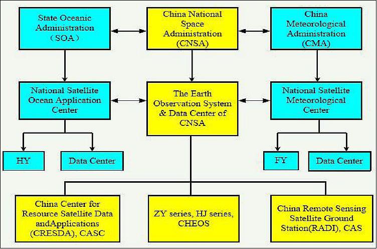
In 2010, the Chinese government approved to implement CHEOS (China High-resolution Earth Observation System), which is an extension of the HDEOS program. The CHEOS series will consist of seven optical/microwave satellites. EOSDC-CNSA (Earth Observation System and Data Center - China National Space Administration) is responsible for organizing the construction of the CHEOS program. The CHEOS program comprises the elements of the spaceborne system, the near-space system, aerial system, the ground system and application system as a whole to realize Earth observation at high temporal, spatial and spectral resolution. 2) 3) 4)
China's push into high-resolution optical Earth observation through its seven-satellite CHEOS system is slightly delayed but will see the launch of a second satellite in 2014 and three more satellites by 2016, according to CNSA (China National Space Administration). 5)
The implementation plan of CHEOS satellite series is as follows:
• Construction period: 2010-2020
• The second satellite (GF-2) will be launched in 2014 and be put into service.
• By 2016, the next three satellites will be launched.
• CRESDA planned to have the entire CHEOS series of satellites in orbit by 2020, but the window has been extended to allow additional satellites to be deployed.
Gaofen Missions in the CHEOS Program
There are 37 other Gaofen satellites launched as part of the CHEOS program as of June 2023, as listed in Table 1.
| Mission | Alternate Name | Launch Date |
|---|---|---|
| Gaofen 1-02, 03, 04 | GF 1-02, 03, 04 | 30 March 2018 |
| Gaofen-2 | GF-2 | 19 August 2014 |
| Gaofen-3 | GF-3 | 9 August 2016 |
| Gaofen 3-02, 3-03 | GF 3-02, 3-03 | 22 November 2012 and 6 April 2022 |
| Gaofen-4 | GF-4 | 28 December 2015 |
| Gaofen-5, 5-02 | GF-5, 5-02 | 8 May 2018 and 7 September 2021 |
| Gaofen 5-01A | GF 5-01A | 8 December 2022 |
| Gaofen-6 | GF-6 | 2 June 2018 |
| Gaofen-7 | GF-7 | 3 November 2019 |
| Gaofen-8 | GF-8 | 26 June 2015 |
| Gaofen 9-01, 02, 03, 04, 05 | GF 9-01, 02, 03, 04, 05 | 14 September 2015, 31 May 2020, 17 June 2020, 6 August 2020 and 23 August 2020 |
| Gaofen-10, 10R | GF-10, 10R | 31 August 2016 and 4 October 2019 |
| Gaofen 11-01, 11-02, 11-03, 11-04 | GF 11-01, 11-02, 11-03, 11-04 / JB-16 1, 2, 3, 4 | 31 July 2016, 7 September 2020, 20 november 2021 and 27 December 2022 |
| Gaofen-12, 12-02, 12-03 | GF-12, 12-02, 12-03 | 27 November 2019, 30 march 2021 and 27 June 2022 |
| Gaofen-13, 13-02 | GF-13, 13-02 | 11 October 2020 and 17 March 2023 |
| Gaofen-14 | GF-14 | 6 December 2020 |
| Gaofen Duomo | GF-DM | 3 July 2020 |
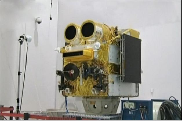
Spacecraft
Gaofen-1 is based on the CAST small satellite bus designed and developed by the China SpaceSat Co. Ltd. of Beijing (also referred to as DFH Satellite Co. Ltd.), the commercial subsidiary of CAST (Chinese Academy of Space Technology). The satellite is equipped with a pair of solar panel wings, each with three solar panels. The CAST-2000 bus is a small platform with high performance, expandability and flexibility. The CAST-2000 bus is of HJ (Huan Jing)-1A and -1B mission heritage, both spacecraft were launched in Sept. 2008.
ADCS (Attitude Determination and Control Subsystem): The spacecraft is 3-axis stabilized; it has the capabilities of highly precise control, large-range sway maneuver, flexible orbit maneuver, highly integrated housekeeping and highly effective power supply. The ADCS uses a 3-axis star tracker, gyroscope, infrared earth sensors and digital sun sensors. Actuators are reaction wheels, magnetic torques, solar array drivers with BAPTA (Bearing And Power Transfer Assembly) and a propulsion subsystem with 8 years' fuel.
No | Item | Requirement | On orbit test(nadir) | On orbit test(off nadir) |
1 | Roll, Pitch, Yaw pointing accuracy (3σ) | ≤0.1º | ≤0.0004º | ≤0.003º |
2 | Roll, Pitch, Yaw attitude stability (3σ) | ≤0.0005º/s | ≤0.0002º/s | ≤0.0003º/s |
3 | Solar array pointing accuracy (3σ) | ≤5º | ≤2º | - |
4 | Slewing time | ≤200s/25º | - | ≤185s/25º |
5 | Roll frequency | 4 times / pass | Roll 4 times/pass | |
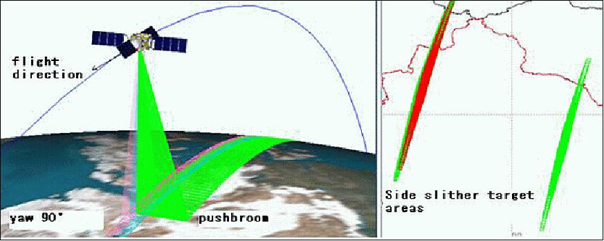
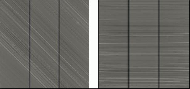
The ADCS of GF-1 has the capability of large angle rapid maneuvers, side-slither maneuvers (90º yaw), and two-dimensional data transmission antenna pointing control. In the star tracker and gyro mode, GF-1 realizes high accuracy pointing and attitude stability. GF-1 is China's first spacecraft with a side-slither calibration adopting a 90º attitude yaw maneuver to realize relative radiometric calibration using the side-slither technique. In this configuration, each detector on the focal plane is positioned parallel to the ground-track direction thereby exposing each detector from the same segment of the ground
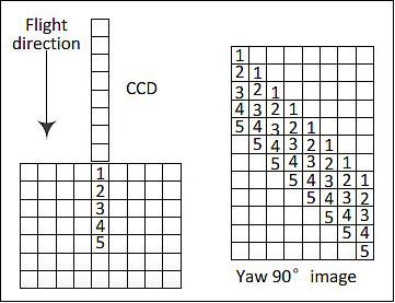
On May 1, 2013, the GF-1 spacecraft yawed 90° and performed side-slither calibrations three times on orbit. This maneuver produced a radiometric flat-field input to the sensor so that the relative response of each detector was determined for the same exposure level. The side-slither derived detector correction parameters were then used to improve the quality of the GF-1 imagery. A significant improvement in image correction was achieved (Ref. TCS (Thermal Control Subsystem): The TCS employs mainly passive thermal control methods (such as heat insulation, scatter heat, isothermal), aided with active thermal control methods.
RF communications: the spacecraft features an S-band TT&C subsystem and an X-band data transmission subsystem. The Pan imagery is compressed by a JPEG 3:1 algorithm, while the 8 m and 16 m MS data are compressed with a lossless algorithm to ensure image quality.
The Gaofen-1 spacecraft has a launch mass of 1080 kg. The design life is 5 years with a mission goal of 8 years. 6)
Long life design features:
- All instruments' life time are designed longer than 5 years.
- Key units and functions are redundant. Some safety modes can be operated autonomously in order to ensure power.
- Rotational units like BAPTA and the X-band rotating antenna are required to speedup tests of > 10 years.
- Li-ion batteries are required to test charge and discharge of 30%DOD
- The inclination offset technology is a key design feature which can realize LTDN (Local Time on Descending Node) range inside 10:30±30 min with no need to adjust inclination (fuel saving).
Launch mass | 1080 kg | |
Spacecraft bus | CAST-2000 (extended version) | |
Spacecraft design life | 5~8 years | |
ADCS (Attitude Determination and Control Subsystem) | 3-axis stabilized, zero momentum stabilization, Earth pointing | |
Spacecraft agility | Roll ~25º( normal), ~35º(max), Yaw 90º (calibration) | |
Geolocation of imagery | 50 m without GCP (Ground Control Point) | |
EPS (Electrical Power Subsystem) | Solar power = 1278 W, output current from arrays= 40-42.6 A, Li-ion battery capacity= 80 Ah | |
Main sensor complement | 2 x HR (High Resolution Cameras) | 4 x WFV(Wide field of view Cameras) |
Spatial resolution | Pan: 2 m; MS: 8 m(nadir) | MS 16 m(nadir) |
Swath width | 69 km with two cameras(nadir) | 830 km with 4 cameras mosaic(nadir) |
Data quantization | 10 bit | 10 bit |
Revisit capability | Revisit ≤4 days at equator(roll near 25º) | Recover any places in 4 days(no need for roll) |
Note: The Gaofen-1 and the VRSS-1 (Venezuelan Remote Sensing Satellite-1) satellites were both developed at DFH Co. Ltd. using the same CAST-2000 platform.
Launch
The GF-1 spacecraft was launched on April 26, 2013 on a CZ-2D (Long March -2D) vehicle from the JSLC (Jiuquan Satellite Launch Center) in northwest China. The GF-1 spacecraft is the first demonstration mission of the CHEOS program (Ref. 2). 8) 9)
Orbit: Sun-synchronous orbit, altitude 645 km, inclination = 98º, LTDN (Local Time on Descending Node) = 10:30 hours, revisit frequency of ≤4 days.
The secondary payloads were:
• TurkSat-3USat, a nanosatellite (3U CubeSat, ~ 4 kg) of ITU (Istanbul Technical University), Istanbul, Turkey.
• NEE-01 Pegasus, a CubeSat of EXA (Ecuadorian Civilian Space Agency), Ecuador.
• CubeBug-1 of INVAP, a 2U CubeSat of Argentina, sponsored by the Argentinian Ministry of Science, Technology and Productive Innovation, INVAP S.E., Satellogic SA, and Radio Club Bariloche.
The GF-2 spacecraft was launched on August 19, 2014 on a CZ-4B (Long March 4B) vehicle from the TSLC (Taiyuan Satellite Launch Center), China.
As of June 2023, 36 more Gaofen satellites have launched as part of the CHEOS program since GF-2 in 2014. The most recent launch was Gaofen 13-02 (GF 13-02), launched on March 17 2023.
Secondary payload:
The BRITE-PL-2 nanosatellite, also referred to as Heweliusz, of SRC/PAS (Space Research Center/ Polish Academy of Sciences of Warsaw, Poland.
Mission Status
• June 2023: The Gaofen-1 mission was extended and the GF-1 spacecraft and its payload were still operational. 23)
• September 2016: The GF-1 spacecraft and its payload were operating nominally. The data it collected was widely used in the fields of land dynamic monitoring, mineral resources exploring, environment monitoring, disaster monitoring and mitigation, etc. 10)
• August 2015: The GF-1 spacecraft and its payload were operating nominally after more than 2 years on orbit. GF-1 served a wide range of applications covering many topics. The typical applications with high resolution and wide swath satellite data include: 11) Monitoring land cover change for environmental monitoring; agricultural applications, such as crop monitoring and management to help food security; detailed vegetation and forest monitoring and parameter generation (e.g. leaf area index, chlorophyll concentration, carbon mass estimations); observation of coastal zones (marine environmental monitoring, coastal zone mapping) ; inland water monitoring and flood mapping & management (risk analysis, loss assessment, and disaster management during floods).
• March 6, 2015: The Gaofen-2 spacecraft was declared operational. The services provided by the satellite were intended to help boost development of the China's data application and spatial information sectors12) According to the project information, GF-2 has a spatial resolution of 0.8 m and a multispectral resolution of 3.2 m.
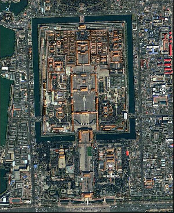
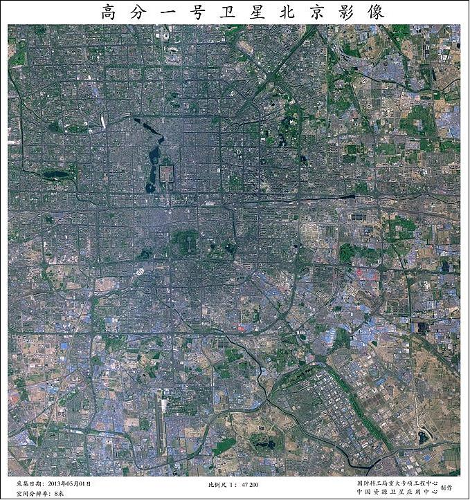
• February 2015: The Earth Observation and Data Center of CNSA presented some images of GF-1 acquired in 2014. 13)


• October 2014: The GF-1 spacecraft and its payload were operating nominally. 14)
• June 2014: The GF-1 spacecraft (a demonstration satellite in the GF family) and its payload are operating nominally. The agile GF-1 provides several acquisition modes. For example, the spacecraft can provide up to 4 different roll acquisitions in one orbit and/or provide a 90º side-slither calibration (Ref. 7). The EOSDC-CNSA facilitates and provides GF-1 data to various clients including tens of national ministries and agencies, local governments, research institutions, universities, enterprises and organizations in China. EOSDC-CNSA is eager to distribute Gaofen data in international cooperation agreements (Ref. 3).
• March 2014: 550,000 scenes were delivered. Among them, the 2 m Pan and 8 m MS data covering an area of about 93% of China effectively; the 16 m MS data cover China over 10 times effectively.
• February 2014: The Gaofen-1 spacecraft and its payload are operating nominally. The in-orbit test demonstrates that the performance of GF-1 meets the design requirements completely (Ref. 5).
• December 30, 2013: Gaofen-1, China's high-definition Earth observation satellite, has been formally put into service, as reported by SASTIND (State Administration of Science, Technology and Industry for National Defense). 15) 16) 17) The satellite had undergone eight months of in-orbit tests since it blasted off on April 26. The satellite has provided data on the Lushan earthquake in Sichuan, floods in northeastern China and the smog in northern and eastern China during the test period. It also provided Pakistan with images after an earthquake in the country on September 24, 2013.
• September 29, 2013: The satellite finished orbital commissioning and tested application in the areas of land resources, environmental protection and agriculture. The result of orbital commissioning shows: the main test results are better than expected. The image quality is excellent. (Ref. 14).
• June 6, 2013: SASTIND released the first 13 photos from the high-resolution earth observation satellite Gaofen-1. The images feature four cities, including Beijing, Shanghai, Yinchuan and Datong. 18)
• May 1, 2013: An engineering test mission took place. It took 6 days to finish the follow items test items (Ref. 7): Day 1: Solar arrays deployed, normal 3-axis attitude control, set up platform, antennas deployed; Day 2: Set up of star sensors, RF of DTS (Data Transmission System) test; Day 3: Cameras took photos with different roll angles; Day 4 and 5: Payload and DTS test, different working modes, adjust focus, DTS transmit to double stations and on Day 6: Spacecraft in yaw angle configuration of 90º and side slither calibration; continues to roll 4 times in one orbit. GF-1 is China's first spacecraft which adopted an attitude yaw configuration of 90º to realize relative radiometric calibration using the side-slither technique. In this configuration, each detector in the focal plane was positioned parallel to the ground-track direction thereby exposing each detector from the same segment of the ground.
• April 28, 2013: the RADI Miyun Ground Station succeeded in receiving the first track of image data from the Gaofen-1 spacecraft. 20)
Sensor Complement
The satellite is configured with two 2 m barrel-mounted panchromatic/8 m MS (Multispectral) cameras, and a set of 4 WFIs (Wide Field Imagers) with 16 m MS medium-resolution and a combined swath of 830 km. The revisit frequency of the spacecraft is ≤4 days and the observation range of the mission covers a region between 80ºN to ~80ºS. The data of the GF-1 mission are being used in the following application areas: land resource investigation, mineral resource management, atmospheric and water environment quality monitoring, and natural disaster emergency response and monitoring.
The complete camera set of PMC and WFI (6 cameras) may observe simultaneously, or each camera set (PMC or WFI) may observe separately, if required. 21)
PMC (PAN and Multispectral Camera)
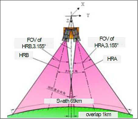
PMC is a high-resolution pushbroom imager (2 cameras) with TDI (Time Delay Integration) capability observing in the visible range at a resolution of 2 m in PAN, and of 8 m in MS (Multispectral)mode. Note: the PMC is also referred to as HR (High Resolution). The PMC features a TMA (Three Mirror Anastigmat) optical system with PAN and 4 MS TDI (Time Delay Integration) CCD focal planes.
Imager type | Pushbroom with TDI capability |
Spectral bands | PAN: 0.45-90 µm |
GSD (Ground Sample Distance) at nadir | PAN: 2.0 m |
Swath width at nadir | 69 km |
Detector type | CCD array |
WFI (Wide Field Imager)
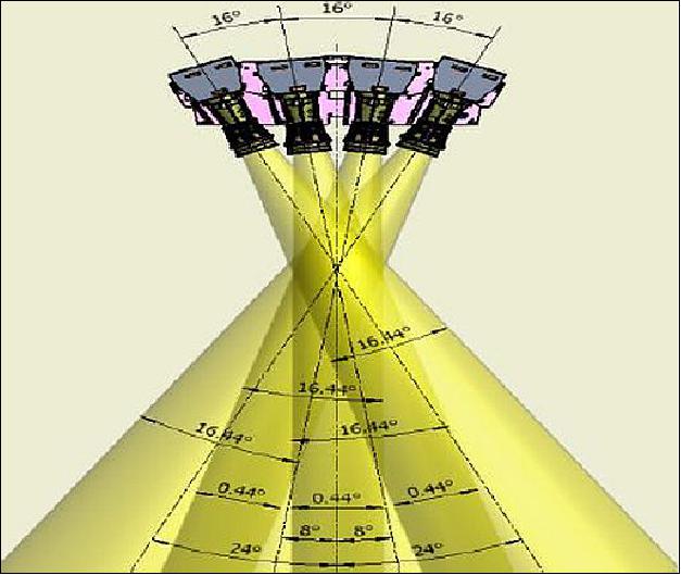
WFI is a medium-resolution pushbroom camera set with TDI (Time Delay Integration) capability observing in the VNIR range at a spatial resolution of 16 m in MS mode. There are four barrel-mounted cameras (WFIs) with a combined overlapping swath of 830 km. In Figure 14, the WFI camera set window is visible in the elongated slot underneath the two openings for the high-resolution PMC set. The four WFI cameras are mounted side by side in this slot, coverging the wide FOV (Field of View). The mounting on the platform pointing covers the range from -24º, -8º, +8º to +24º. Each camera has 4 multispectral bands using prism to realize beam-splitter. The spectral bands span from the visible (VIS) to the near infra-red (NIR).
Imager type | Pushbroom with TDI capability |
Spectral bands | B1/blue: 0.45-0.52 µm |
GSD (Ground Sample Distance) at nadir | 16 m |
Swath width at nadir | 830 km |
Detector type | CCD array |
References
1) "China launches Gaofen-1 satellite," Xinhua, April 26, 2013, URL:
http://www.china.org.cn/china/2013-04/26/content_28668480.htm
2) H. Qi, "China High-resolution Earth Observation System (CHEOS) and its Latest Development," Proceedings of the 51st Session of Scientific & Technical Subcommittee of UNCOPUOS, Vienna, Austria, Feb. 11-22, 2014, URL: http://www.unoosa.org/pdf/pres/stsc2014/tech-47E.pdf
3) Guang Zhou, "Construction and Development of China High-Resolution Earth Observation System," 42nd session of the Coordination Group for Meteorological Satellites (CGMS), Guangzhou, China, 19-23 May 2014, URL: http://www.eumetsat.int/website/wcm/idc
/idcplg?IdcService=GET_FILE&RevisionSelectionMethod=LatestReleased
&Rendition=Web&dDocName=CWPT_1299
4) "Chiina Hiigh-resollutiion Earth Observatiion System (CHEOS) and iits Lastest Devellopment," The Earth Observation System and Data Center , CNSA, 2014-2, URL: http://www.oosa.unvienna.org/pdf/pres/stsc2014/tech-47E.pdf
5) Peter B. de Selding, "China Pushing Ahead on Hi-Res Satellite System," Space News, Feb. 28, 2014, URL: http://spacenews.com/article/civil-space/39665china-pushing-ahead-on-hi-res-satellite-system
6) Rui C. Barbosa, "China back in action with Long March 2D launch of Gaofen-1," NASA Spaceflight.com, April 25, 2013, URL:
http://www.nasaspaceflight.com/2013/04/china-back-in-action-long-march-2d-gaofen-1/
7) Chunling Lu, Zhaoguang Bai, "GF‐1 Satellite On‐Orbit Test and Evaluation," Proceedings of the 4S (Small Satellites Systems and Services) Symposium, Port Petro, Majorca Island, Spain, May 26-30, 2014
8) Stephen Clark, "Four satellites launched on China's Long March rocket," Spaceflight Now, April 26, 2013, URL: http://www.spaceflightnow.com/news/n1304/26longmarch/#.UXuGc0okS2o
9) Patrick Blau, "Long March 2D performs China's first Orbital Launch of 2013," Spaceflight 101, April 26, 2013, URL: http://www.spaceflight101.com/long-march-2d-gaofen-1-launch.html
10) Ming Li, Pan Teng, Cao Haiyi, "An Overview of Satellite Project of the National High Resolution Earth Observation System (NHREOS)," Proceedings of the 67th IAC (International Astronautical Congress), Guadalajara, Mexico, Sept. 26-30, 2016, paper: IAC-16,B1,2,1
11) Chunling Lu, Zhaoguang Bai, "Characteristics and Typical Applications of GF-1 satellite," Proceedings of the IGARSS (International Geoscience and Remote Sensing Symposium) 2015, Milan, Italy, July 26-31, 2015
12) "Chinese HD earth observation satellite comes into service," Space Daily, March 9. 2015, URL: http://www.spacedaily.com/reports
/Chinese_HD_earth_observation_satellite_comes_into_service_999.html
13) S. Cheng, "Introduction to Application Achievement of GF-1 and GF-2 Satellite," 52nd session of the Scientific and Technical Subcommittee, UNOOSA (United Nations Office for Outer Affairs), Vienna, Austria, Feb. 2-13, 2015, URL: http://www.unoosa.org/pdf/pres/stsc2015/tech-63E.pdf
14) Cunling Lu, Zhaoguang Bai, Changjun Li, Damin Li, "GF-1 satellite high resolution & wide swath system design and technology characteristics," Proceedings of the 65th International Astronautical Congress (IAC 2014), Toronto, Canada, Sept. 29-Oct. 3, 2014, paper: IAC-14-B4.4.2
15) "China's HD observation satellite opens its eyes," Space Daily, Dec. 31, 2013, URL: http://www.spacedaily.com/reports/Chinas_HD_observation_satellite_opens_its_eyes_999.html
16) "Gaofen-1 satellite goes into service," Xinhua, Dec. 31, 2013, URL: http://www.shanghaidaily.com/national/Gaofen1-satellite-goes-into-service/shdaily.shtml
17) "China's HD Earth Observation Satellite Put into Use," CRIEnglish.com, Dec. 30, 2013, URL: http://english.cri.cn/6909/2013/12/30/2743s805813.htm
18) "China publicizes Earth observation satellite's HD photos," Xinhua, June 6, 2013, URL: http://www.china.org.cn/china/Off_the_Wire/2013-06/06/content_29045699.htm
19) Information provided by Joaquin Guo, Representative of Latin America, China Great Wall Industry Corporation (CGWIC)
20) "Reception of the First Image Data from Gaofen-1," Institute of Remote sensing and Digital Earth (RADI), URL: http://english.radi.cas.cn/Research/RP/201307/t20130717_106431.html
21) Information provided by Chunling Lu of DFH (Dong Fang Hong) Satellite Co. Ltd., Beijing, China.
22) Krebs, Gunter, “Gaofen 13-02 (GF 13-02)”, Gunter’s Space Page, URL: https://space.skyrocket.de/doc_sdat/gf-13.htm
23) Wikipedia, “Gaofen”, URL: https://en.wikipedia.org/wiki/Gaofen
Overview Spacecraft Launch Mission Status Sensor Complement References Back to top