PRISM (Portable Remote Imaging Spectrometer)
Airborne Sensors
PRISM (Portable Remote Imaging Spectrometer) Airborne Instrument
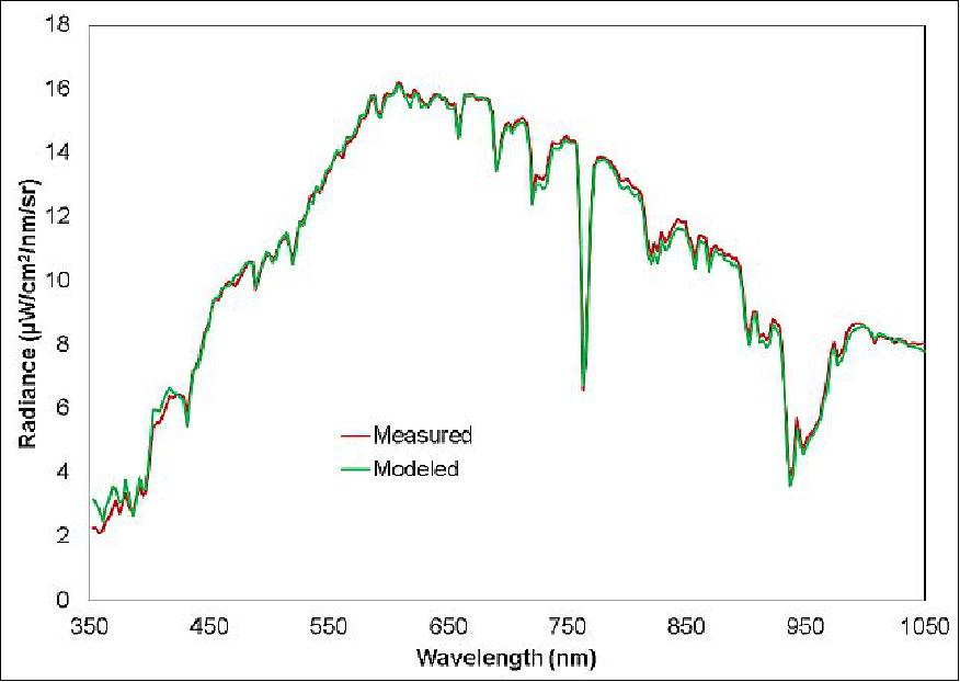
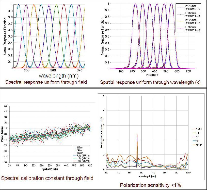
PRISM is a NASA state-of-the-art imaging spectrometer optimized for the needs of coastal ocean science, providing high SNR and dynamic range, low polarization sensitivity, high spatial resolution, and high uniformity.The development of the PRISM instrument was supported by NASA ESTO (Earth Science Technology Office), Airborne Sciences Program, and the Ocean Biology and Biogeochemistry Division. 1) 2) 3) 4)
PRISM was conceived in response to a proposal call from NASA's Ocean Biology and Biogeochemsitry Program. Development was initiated in September 2009 and delivery is expected in 2012. After a calibration flight, the instrument will prove its utility through a planned investigation of eelgrass beds in the Elkhorn Slough area of Monterey Bay in California, followed by delivery to NASA to be made available for on-demand use by the Ocean Science community.
Sensors for Ocean Science measurements are distinguished from those used for land measurements by the fact that the reflectivity of water is generally low compared with the typical reflectivity of land targets. This leads to the requirement for achieving a high signal-to-noise ratio in the visible and near infrared range and minimizing the polarization dependence of the sensor transmission, in addition to a robust atmospheric correction strategy. The PRISM design responds to these challenges by utilizing several innovations including:
1) a design that minimizes the number of elements, maintains low angles of incidence on optical surfaces, allows large aperture (F/1.8), and minimizes distortions, and
2) a polarization-insensitive diffraction grating fabricated by electron-beam lithography.
The system is enabled by a rapid snapshot readout detector array and specially developed low-noise readout electronics.
Instrument
PRISM comprises a pushbroom imaging spectrometer covering the near UV to near IR range (350-1050 nm) and a separate spot radiometer covering two short wave infrared (SWIR) bands at 1240 and 1610 nm, respectively.
Spectral | Range | 349.9 – 1053.5 nm |
Spatial | FOV (Field of View) | 30.7º |
Radiometric | Range | 0 – 99% R |
Uniformity | Spectral cross-track uniformity | >95% |
Parameter | Channel 1 | Channel 2 |
Channel center | 1242 nm | 1608 nm |
Bandwidth (FWHM) | 22 nm | 56 nm |
FOV (FWHM) | 2.4 mrad | 2.4 mrad |
Boresight knowledge (relative to spectrometer) | 0.05 mrad | 0.05 mrad |
Sampling | 13 bit | 13 bit |
SNR @ 1.2 mW/cm2 sr | 325 | 390 |
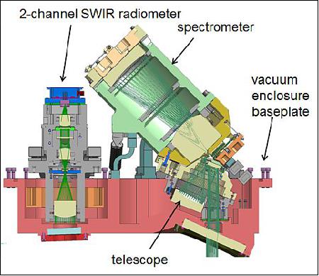
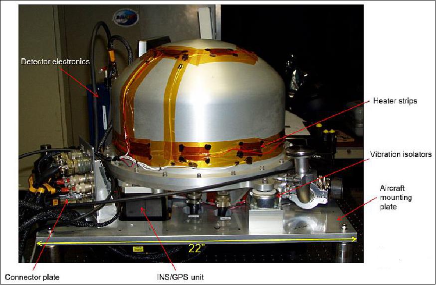
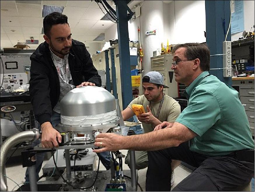
The complete sensor comprises the OHA (Optical Head Assembly) and control electronics. At about 40 kg, the OHA comprises the vacuum vessel with the spectrometer and SWIR radiometer inside, an aircraft interface/mounting plate, an INS/GPS unit attached to the optical head for enabling precise orthorectification and geolocation, as well as the preamplifier and ADC (Analog Digital Converter) for the detector electronics. The vacuum vessel shell is temperature-stabilized to around 26°C with external strip heaters. The required vacuum level for stable operation is < 3 mTorr. The instrument retains this vacuum level through a typical flight without on-board pumping. Three commercial vibration isolators prevent high frequency vibration from transmitting to the optics and detectors.
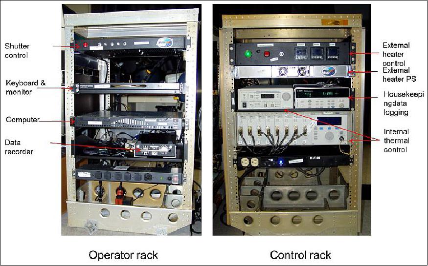
The control electronics can be configured in one or two racks. The control computer passes the high speed data stream to a CORE® DVR data recording unit where the data is stored on solid state drives with a total capacity of 1.5 TB (expandable). The drives are removed after the flight and the data downloaded to another computer for same-day processing. The remaining electronics are dedicated to thermal control and data logging. The temperature of the instruments inside the vacuum vessel is kept at 25°C through bi-directional thermoelectric coolers. The spectrometer detector is running at a temperature of about 7°C. Shutters for the SWIR radiometer and spectrometer provide dark frame acquisition.
The operator's task is to click on a software "record" or "stop" button at the beginning and end of a flight line. Dark frames are acquired automatically at those times. If desired, the computer displays temperature data from the various sensor locations in the OHA, in addition to a "waterfall" display of the data being acquired. Data are digitized to 14 bits and output to an IO Industries CORE® recorder utilizing removable solid state drives. Software control of the PRISM instrument is provided by a specially developed Windows application, which communicates with IO Industries software through an IOI-provided library. The software is used to start and stop recording, and to export image data post-flight. Geolocation data are acquired from a Systron-Donner C-MIGITS III unit and correlated to the FPA readout within ±100 µs to ensure pointing knowledge within one IFOV.
In deployment, PRISM is accompanied by a calibration monitoring assembly comprising a 30.5 cm diameter integrating sphere with customized port, stabilized tungsten halogen source, calibrated broadband detector, and low-pressure Hg lamp source. The integrating sphere is hermetically mated to the spectrometer and SWIR radiometer window using a simple clip-on mechanism. To confirm stability, a reading of the sphere output may be taken by the instrument before and after the flight without removing it from the aircraft mount.
History
• PRISM development award: 2009
• First flight: May 2012
• Additional science campaigns: January 2014, May 2014, September 2014
• All campaigns utilized Twin Otter Aircraft (GRC and TOIL).
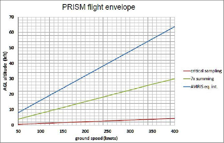
• Typical altitude range 1-10 kft (300-3000 m)
• Reached maximum TO aircraft altitude of >20 kft (>6000 m) in May 2014.
Currently, the plans call for the installation of the PRISM instrument into the ER-2 aircraft for high altitude and wide area coverage.
Modification | Reason | Impact | Twin Otter |
Additional window | Pressurized cabin | ~0.3% polarization | No |
Add getter pump | Longer flight duration | 7 x better vacuum lifetime | Optional |
FPA thermal control | Potential of extreme heat | Better calibration stability, | Yes |
New thermal control electronics | Compatibility with automated | Significant size reduction, | Yes |
Software for automated operation | No operator | None | Optional |
New external heater controller | Failure at low pressure, new | None | Yes |
New power supplies | Enable multi-instrument | None | Yes |
New calibration sphere | New window and distance to | Harder to compare with | Optional |
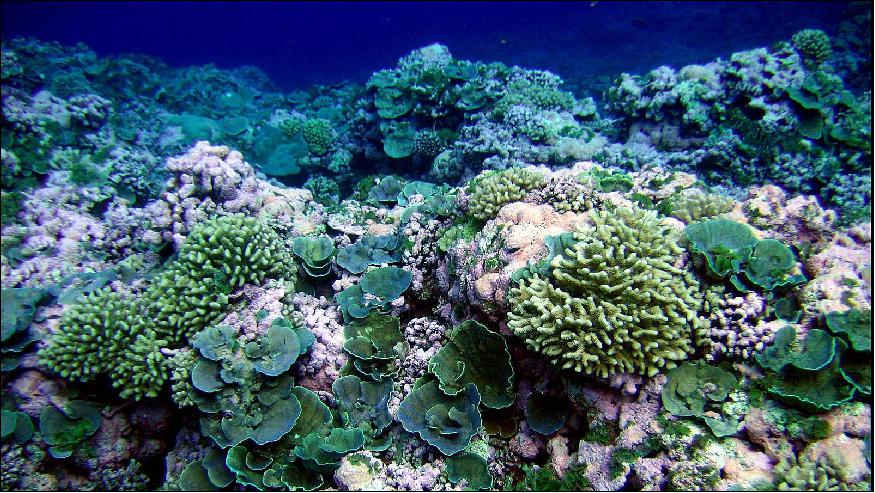
PRISM Brings Coasts and Coral Into Focus
A coastal scene with deep blue seas and a coral reef is beautiful to look at, but if you try to record the scene with a camera or a scientific instrument, the results are almost always disappointing. Most cameras can't "see" underwater objects in such scenes because they're so dim and wash out the glaring seashore. These problems don't just ruin vacation photos. They're a serious hindrance for scientists who need images of the coastline to study how these ecosystems are being affected by climate change, development and other hazards. 5)
To the rescue: the new PRISM (Portable Remote Imaging Spectrometer), created at NASA's Jet Propulsion Laboratory, Pasadena, California. PRISM is an airborne instrument designed to observe hard-to-see coastal water phenomena. In NASA's upcoming CORAL (Coral Reef Airborne Laboratory) field experiment, PRISM will observe entire reef ecosystems in more of the world's reef area - hundreds of times more — than has ever been observed before.
"Coastal ocean science has specific requirements that had not been met with other instruments" when PRISM was initially proposed, said Pantazis Mouroulis of JPL, who designed the instrument. "At that time, it was not even known whether anyone could design an instrument with those characteristics. We had to devise new techniques for assembling and aligning the instrument, and even new technologies for the components."
With devastating coral bleaching taking place around the world, a sensor that can collect a detailed, uniform, large-scale dataset on coral reefs could hardly be more timely. "The value of doing this investigation right now is unimaginable because of the speed at which the environment is changing, and PRISM is the perfect instrument at the perfect time," said JPL's David Thompson, who with Bo-Cai Gao, Zhongping Lee and the CORAL science team is designing a computer model to use with PRISM's measurements for CORAL. "It's such a sensitive instrument — beyond anything I've worked with before."
How it Works
PRISM is a spectrometer, an instrument that splits light into its spectrum of wavelengths and measures the intensity of the light at each individual wavelength. Every type of molecule absorbs a unique combination of wavelengths, leaving dark gaps in the spectrum of light. The pattern of gaps is a sort of spectral "bar code" for that molecule. Spectrometers collect light and record these spectral patterns in it.
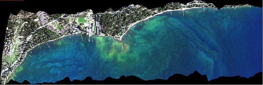
PRISM's spectrometer collects spectra in the visible, ultraviolet and near-infrared wavelengths, which encompass the "bar codes" for most phenomena of interest along coastlines. Because it is an airborne instrument, PRISM can measure wide swaths of coastline repeatedly in a short period of time — important when monitoring rapidly changing conditions such as rising floodwaters — and it creates a dataset on a regional scale, but with an amount of detail approaching what can be collected by boat-based campaigns. Boat campaigns can only produce local-scale datasets, because they are so expensive and labor intensive.
PRISM measures all spectra in the entire scene below its airborne perch. Each airborne campaign that uses the instrument can select just the spectra it needs for its area of study. For the CORAL campaign, "We're after that fraction of light that makes it all the way to the bottom of the ocean and comes back to the sensor, which carries the signal of the health of the coral reef," said Thompson. Thompson designed his computer algorithms to eliminate the unneeded light and isolate just the seafloor spectra. "You can think of it as peeling back the layers of an onion," he said. "Atmospheric haze is different from the surface glint off the ocean, which is different from light that's gone partway down into the ocean, which is different from light that's gone all the way down [to the seafloor and back]. All those other optical paths have to be eliminated in our modeling."
To test Thompson's model, the light from each "onion layer" is compared against measurements of the same thing — the amount of atmospheric haze and the light-changing properties of the ocean water, for example — taken aboard boats at a few points along the plane's path at the same time the instrument flies overhead. "It's critical for the math [in the model] to be tied down at different points with actual, physical measurements," Thompson said. When a shipboard measurement of the water's murkiness agrees with the model's calculation of the same thing, for example, it gives confidence that the model is correctly interpreting the spectra collected by PRISM.
How it's Working
Heidi Dierssen, an oceanographer and professor at the University of Connecticut, Groton, and co-investigator in the CORAL campaign, worked on the development of PRISM and took the instrument on its first field campaign to study eelgrass in California's coastal waters. Dierssen has used many different instruments to gather coastal data in the past. When she used sensors that were optimized for land to observe the ocean, "They failed to give us good signals," she said. "When you looked at a spectrum it was often wavy, and you had to spend a lot of effort to calibrate it to what you measured in the water." When she used PRISM, "I was shocked," she said. "The first time we collected imagery, we got very good agreement with the field data. That instrument is truly a leap forward."
CORAL's project scientist, Michelle Gierach of JPL, has seen PRISM's data from Dierssen's study and used the instrument to observe ocean color (which can indicate phytoplankton presence) in the sea around Antarctica last winter. "We have only begun to scratch the surface of what PRISM is capable of doing, from eelgrass to biology within the Southern Ocean to now assessing coral reefs throughout the western tropical Pacific," she said. "Those are just some of the things that PRISM has in its arsenal. There's so much more that is possible."
CORAL (COral Reef Airborne Laboratory)
NASA's new CORAL field campaign kicks off its data-gathering phase with an operational readiness test on Oahu, Hawaii, starting the week of June 6, 2016. Over the next year, CORAL will conduct airborne and in-water surveys of representative coral reefs from Hawaii to Australia. By focusing on entire reef ecosystems, CORAL scientists will get state-of-the-art insights into how biological, physical and chemical processes shape and affect the ecosystems. These data will help them answer fundamental questions about how reefs are changing globally due to the effects of climate change and human activities. 6)
1) How does CORAL work? It uses a new NASA airborne instrument designed specifically to observe coastal environments. The PRISM (Portable Remote Imaging SpectroMeter) can see objects about 1.5 m x 1.5 m from its airborne perch 8 km overhead. PRISM will fly in a Gulfstream IV airplane, collecting large swaths of data that will allow scientists to distinguish among coral, algae and sand — important information for assessing reef condition — without having to go underwater in each location. This uniform dataset will be an advance over the current data, collected by multiple groups all using different techniques.
2) Reefs are mostly unknown territory. Search online for "coral reef images" and you'll get a million spectacular photos, but they all show just the small fraction of the world's reef area that scuba divers have visited. The fraction that has been scientifically surveyed is even smaller. We simply don't have enough data to understand which impacts to reefs are the most damaging and how resilient reefs are likely to be.
3) Scuba diving for science. For decades, scuba diving has been the gold standard for conducting reef research, allowing scientists to study everything from coral reproduction to the complex relationships between coral and other organisms. However, scuba diving as a method of understanding entire ecosystems leaves a lot to be desired: it is time consuming, labor intensive and costly. CORAL's use of remote sensing technology to survey entire reef ecosystems represents a huge step forward in research capacity.
4) More than just a pretty face. Hard corals have outlived dinosaurs, existing on Earth since the mid-Triassic period, 200-250 million years ago. During this time, they've evolved and diversified to exist across the world's ocean. Reef building corals typically occupy shallow tropical and subtropical waters; however, deep-water corals can be found at depths up to 6,000 m, and coral reefs were recently discovered at the mouth of the Amazon River in turbid, muddy water.
Coral reef ecosystems play a vital role in maintaining Earth's marine biodiversity and are also valuable to humans as a source of food, medical advances and tourism revenue, with total global ecosystem goods and services estimated at $400 billion each year. This number is especially impressive if you consider that the U.N. Environment Program estimates that all the world's reefs would fit into an area smaller than the state of Arizona.
5) Coral or reef? A single coral polyp — consisting of the coral animal, its symbiotic algae and calcium carbonate skeleton — is usually less than 1 cm across. Unlike many animals, corals are colonial, which means that many polyps grow together and form a larger structure. Most corals that you see in aquaria are, in fact, colonies. A coral reef, on the other hand, is an entire ecosystem that includes the individual polyps and their colonies, plus other living (e.g., fish, worms, invertebrates, algae) and nonliving (e.g., sunlight, sand, water) components. Scientists have a pretty good understanding of how individual coral polyps and colonies function, but much less understanding of how the various parts of a reef act individually and collectively to form an ecosystem. CORAL is the first opportunity to study reefs at the ecosystem scale, rather than relying on patchy, inconsistent surveys.
NASA uses the vantage point of space to increase our understanding of our home planet, improve lives and safeguard our future. NASA develops new ways to observe and study Earth's interconnected natural systems with long-term data records. The agency freely shares this unique knowledge and works with institutions around the world to gain new insights into how our planet is changing.
References
1) P. Mouroulis, B. van Gorp, R. O. Green, D. Cohen, D. Wilson, D. Randall, J. Rodriguez, O. Polanco, K. Balasubramanian, R. Vargas, R. Hein, H. Sobel, M. Eastwood, H. Dierssen, "Design of an Airborne Portable Remote Imaging Spectrometer (PRISM) for the Coastal Ocean," Earth Science Technology Forum (ESTF2010), Arlington, VA, June 22-24, 2010, URL: http://esto.nasa.gov/conferences/estf2010/papers/vanGorp_Mouroulis_ESTF2010.pdf
2) "PRISM - Portable Remote Imaging Spectrometer," NASA/JPL, URL: http://prism.jpl.nasa.gov/index.html
3) Pantazis Mouroulis and the PRISM Team, "The Portable Remote Imaging Spectrometer (PRISM): High altitude platform installation," ESTF 2014 (Earth Science Technology Forum), Leesburg, VA, USA, Oct. 28-30, 2014, URL: http://esto.nasa.gov/forum/estf2014/presentations/B5P2_Mouroulis.pdf
4) Pantazis Mouroulis, Byron Van Gorp, Robert O. Green, Heidi Dierssen, Daniel W. Wilson, Michael Eastwood, Joseph Boardman, Bo-Cai Gao, David Cohen, Brian Franklin, Frank Loya, Sarah Lundeen, Alan Mazer, Ian McCubbin, David Randall, Brandon Richardson, Jose I. Rodriguez, Charles Sarture, Eugenio Urquiza, Rudolph Vargas, Victor White, Karl Yee, "The Portable Remote Imaging Spectrometer (PRISM) coastal ocean sensor: design, characteristics and first flight results," Applied Optics Vol. 53 Issue 7, 2014, pp: 1363-1380
5) Alan Buis, "New NASA Instrument Brings Coasts and Coral into Focus," NASA/JPL, May 31,2016, URL: http://www.jpl.nasa.gov/news/news.php?release=2016-137
6) Alan Buis, "Five Things About Coral and CORAL," NASA/JPL, June 2, 2016, URL: http://www.jpl.nasa.gov/news/news.php?feature=6524
The information compiled and edited in this article was provided by Herbert J. Kramer from his documentation of: "Observation of the Earth and Its Environment: Survey of Missions and Sensors" (Springer Verlag) as well as many other sources after the publication of the 4th edition in 2002. - Comments and corrections to this article are always welcome for further updates (eoportal@symbios.space).