ESAIL Maritime Microsatellite
EO
ESA
Ocean
Multi-purpose imagery (ocean)
Quick facts
Overview
| Mission type | EO |
| Agency | ESA |
| Mission status | Operational (nominal) |
| Launch date | 03 Sep 2020 |
| Measurement domain | Ocean |
| Measurement category | Multi-purpose imagery (ocean) |
| Measurement detailed | Ocean imagery and water leaving spectral radiance, Ocean dynamic topography |
| Instrument type | Communications, Data collection |
| CEOS EO Handbook | See ESAIL Maritime Microsatellite summary |
ESAIL Maritime Microsatellite
Spacecraft Sensor Complement Launch Mission Status ION References
Space technology company OHB SE of Bremen, Germany, is widening its range of products with the addition of a new platform for microsatellites. Accordingly, LuxSpace Sarl, OHB's Luxembourg-based subsidiary, has entered into a contract with ESA (European Space Agency). LuxSpace will develop an entirely new, cost-effective and versatile microsatellite platform to be known as "Triton-X". 1)
Triton-X will be opening up new perspectives for the OHB Group in the "new space market" and generating scope for commercial applications. The microsatellites will have a mass of around 80 kg and transport a payload of up to 30 kg to LEO (Low Earth Orbit) at an altitude range of 250-700 km.
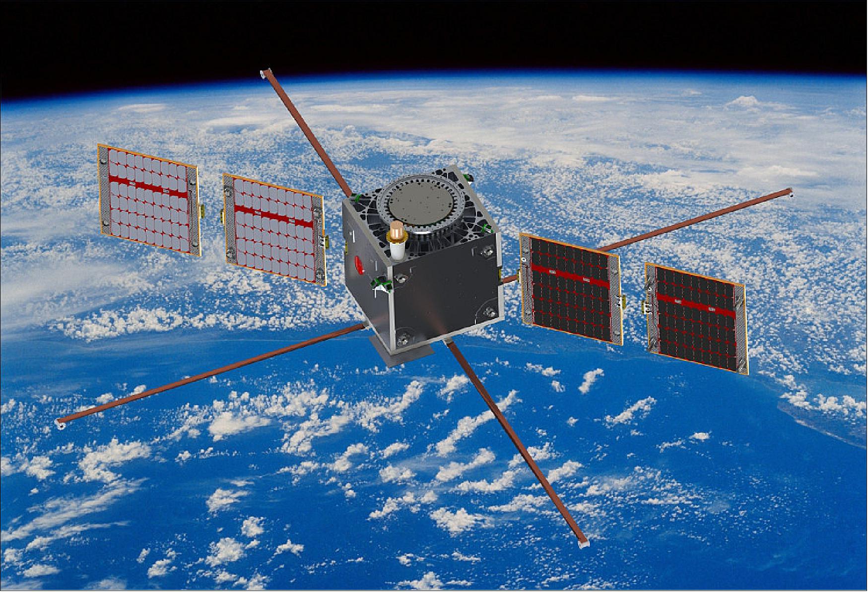
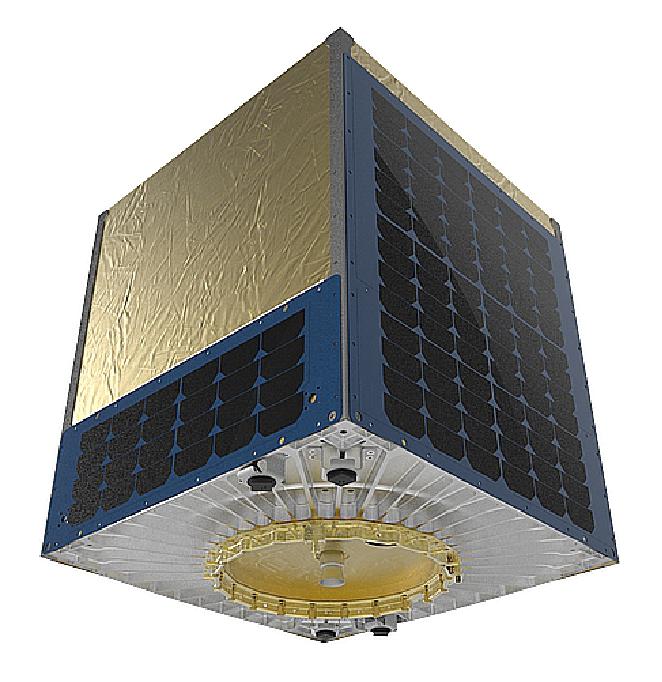
LuxSpace's microsatellite project ESAIL, a PPP (Public-Private-Partnership) with ESA in the ARTES (Advanced Research in Telecommunications Systems) program and the Canadian company exactEarth, has been picking up speed since the first quarter if 2018 after passing important milestones. The payload is an AIS receiver for ship- and vessel detection from space, and the satellite mass at launch will be approximately 110 kg. The satellite payload also enables advanced raw data handling and RF-spectrum sampling for ground processing.
Spacecraft
Triton-X is a new platform reflecting the New Space philosophy, targeting in particular commercial applications for which affordability and time-to-market are paramount. This includes satcoms, earth observation, situational awareness, and technology demonstration. 2)
Enabling affordable LEO (Low Earth Orbit) constellations is a key design requirement for the new platform. This means low recurring costs, with efficient manufacturing, assembly and testing processes optimized for fast time-to-market. To achieve these objectives, LuxSpace will draw on know-how and experience gained through several previous missions, including Pathfinder-2 (LuxSpace's early AIS validation mission), Vesselsat-1 and -2 (both AIS satellites flown for Orbcomm), 4M (the first privately funded Moon mission) and most recently ESAIL, which is based on LuxSpace's Triton-2 high-performance AIS platform that is being developed in an ARTES project between LuxSpace, ESA, and exactEarth .
Project Phases
In the initial phase of Triton-X, LuxSpace will define the overall system architecture. The company will also invite partners to join the project as part of the core industrial team and build long-term industrial relationships to develop the product line.
In the second stage of the project, the Triton-X consortium will embark upon the process of implementing and qualifying the new platform for space.
The third and final phase of the project will encompass the launch of the first Triton-X flight model to gain in-orbit validation. This should pave the way for the deployment of LEO constellations in the future.
"In today's rapid evolution of the space market, ESA is continuing to support European industry in the most effective manner, by adapting with industry to the working methodologies of New Space. Within that context, this project is a good example of how ESA can respond to the needs of Industry as they address the emerging opportunities created by microsatellites," says ESA's Magali Vaissiere, Director of Telecommunications and Integrated Applications.
Development Status
• June 12, 2020: The ESAIL microsatellite for tracking ships worldwide – developed under an ESA Partnership Project – has completed its accommodation on Vega's new dispenser for small satellites and is ready for launch. 3)
- The Vega launch campaign at Europe's spaceport in Kourou, French Guiana, resumed three weeks ago, following an interruption caused by the coronavirus pandemic.
- ESAIL is due to be delivered into a Sun-synchronous orbit at an altitude of more than 500 km on Arianespace's first Vega Small Spacecraft Mission Service (SSMS) rideshare flight. The launch will deliver seven microsatellites and 46 CubeSats into orbit, using a new satellite dispenser that spreads the cost of launch between many customers.
- The ESAIL high-performance microsatellite was built by LuxSpace under an ESA Partnership Project with the Canadian operator exactEarth. The project was supported by the Luxembourg Space Agency and other ESA member states.
- ESA's Partnership Projects aim to develop sustainable end-to-end systems, right up to in-orbit validation.
- ESAIL will track ships worldwide by detecting messages that ships radio-broadcast with their automatic identification systems (AIS).
- As part of exactEarth's satellite-based AIS constellation, ESAIL will provide data also to EMSA (European Maritime Safety Agency) for the next generation of global maritime traffic services.
- ESAIL enables fisheries monitoring, fleet management, environmental protection and security monitoring for maritime and government authorities and industry – making the seas safer.
• July 8, 2019: The ESAIL microsatellite developed under ESA's program for tracking ships at sea is going through its final tests ahead of launch. 4)
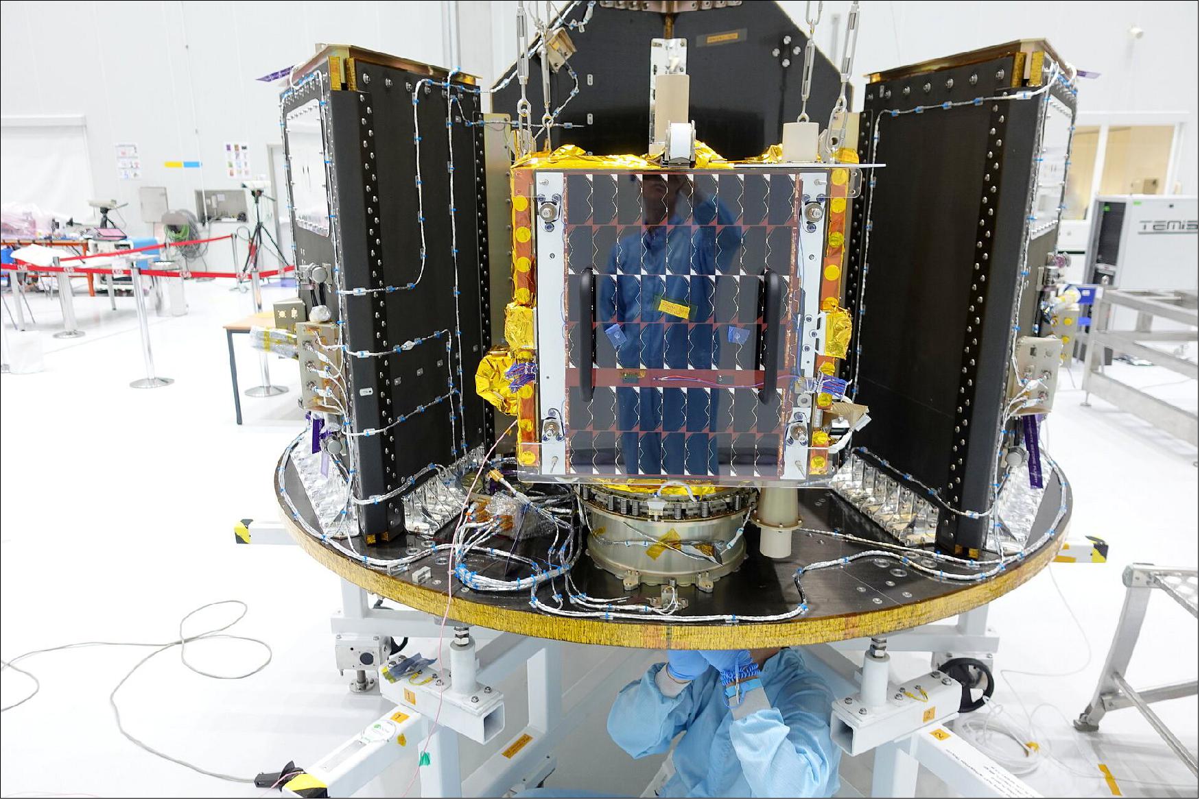
- ESAIL has successfully completed its environmental testing campaign, which was performed in just five weeks in the specialized facilities of CSL (Centre Spatial de Liège) in Belgium.
- The satellite was exposed to mechanical vibrations simulating the violence of a rocket launch, as well as to the extreme temperatures and vacuum similar to those it will experience in its near Earth orbital environment.
- The solar generators and antennas were also deployed to confirm the mechanisms performance after the rough mechanical and thermal vacuum test.
- This achievement was possible thanks to the close cooperation between delegations, industry and the ESA teams.
• May 9, 2019: Arianespace announced today that it has been selected by exactEarth to launch the ESAIL satellite using a Vega as part of the launcher's Small Spacecraft Mission Service (SSMS) Proof of Concept (POC) flight. 5)
- It is the final contract signed by Arianespace for this POC flight, which is now completely booked with 42 payloads onboard.
- Vega's POC flight will be the first mission for SSMS – a program initiated by ESA in 2016 with the contribution of the European Commission. For all European partners involved, its purpose is to perfectly address the burgeoning microsatellite market for both institutional and commercial needs with a new rideshare concept on the Vega light-lift launcher.
• On 9 May 2019, exactEarth the Canadian operator of ESAIL, signed the launch service agreement with Arianespace. 6)
- ESAIL is part of ESA's Partnership Projects and has been developed to enhance the next generation of space‐based services for the maritime sector. The spacecraft will track ship movements over the entire globe as it orbits the planet.
- Satellite coverage is essential as about 90% of global trade takes place on the oceans. It opens the door to enhanced safety, tracking ships and route provisions for industry, government and maritime authorities.
- Ships of 300 tons or more in international voyages, cargo ships of 500 tons or more in local waters and all passenger ships irrespective of size are mandated by the International Maritime Organization to carry AIS (Automatic Identification System) equipment.
- ESAIL's AIS receiver provides advanced antenna beamforming and ground signal processing capabilities. The satellite needs rigorous testing before launch to ensure it can provide this always‐on service.
- The satellite flight model has completed its environmental tests in Centre Spatial de Liège in Belgium, where it was exposed to mechanical vibration testing, simulating the violence of a rocket launch, as well as to the extreme temperatures and vacuum simulating the near Earth orbital environment.
- The satellite is going through the final steps to be ready for launch in August.
- Peter Mabson, chief executive of exactEarth, said: "We are looking forward to adding ESAIL to our industry-leading global maritime satellite constellation, which now consists of more than 60 in-orbit high performance satellite assets. The capabilities on ESAIL will allow us to continue to advance the state-of-the-art in maritime vessel tracking and data services, and will pave the way for future capabilities. I would like to thank ESA and LuxSpace and their satellite manufacturing team for their accomplishments in producing this leading-edge microsatellite."
- Stephane Lascar, Head of Telecommunication Satellite Programs at ESA, said: "ESA's Partnership Projects offer the most appropriate scheme for private and public entities to de-risk investments and answer market needs. They maximize benefits to industry, thanks to ESA's efficient co-management tailored to commercial practices. ESAIL demonstrates once again ESA's capacity to federate operator, industry and small and medium-sized enterprises around challenging programs, achieving competitive leaps forward and economic impact. I should like to thank our partners and participating states for their trust and close cooperation."
- Thomas Görlach, Chief of the Executive Board at LuxSpace, said: "ESAIL is a major milestone for us as a microsatellite solution provider. It enabled us to build and integrate a sophisticated microsatellite while using commercial off the shelf components and thus reducing time for testing and launch qualification. The emerged synergies paved our way towards commercial space. We have gained very valuable experiences and knowledge through ESAIL which serve as inputs for our next milestone: the Triton‐X platform."
Sensor Complement
AIS (Automatic Identification System)
ESAIL features an enhanced multiple antenna-receiver configuration for global detection of AIS messages and high-resolution spectrum capture, which will enable the demonstration of advanced future services such as VDES (VHF Data Exchange System) message reception.
After launch and commissioning, the ESAIL satellite will be integrated into exactEarth's global constellation – which currently consists of more than 60 high-performance maritime monitoring payloads.
Launch
The ESAIL microsatellite for tracking ships worldwide, has been launched on 3 September 2020 (01:51 UTC, 03:51 CEST) aboard an Arianespace Vega from Europe's Spaceport in Kourou, French Guiana. 7)
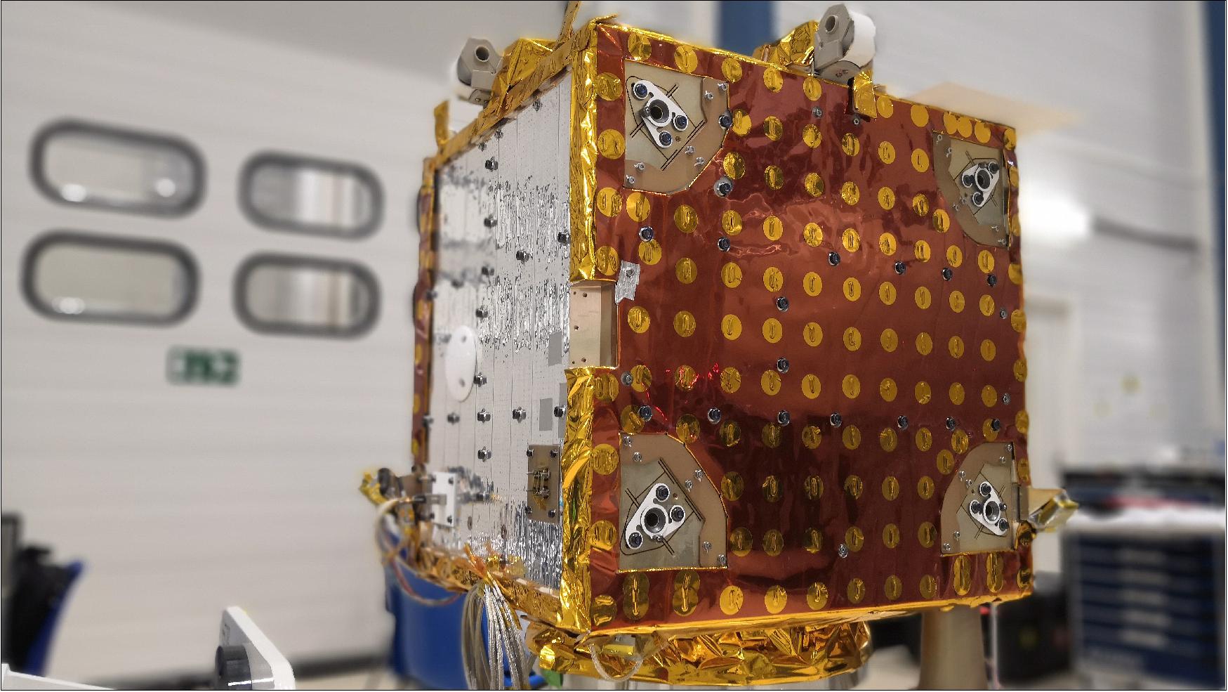
ESAIL, with a mass of 110 kg, was one of 53 passenger satellites on Arianespace's rideshare adapter for Small Satellite Mission Service (SSMS) and was deployed into a Sun-synchronous orbit at an altitude of 515 km with an inclination of 97.45º.
Mission Status
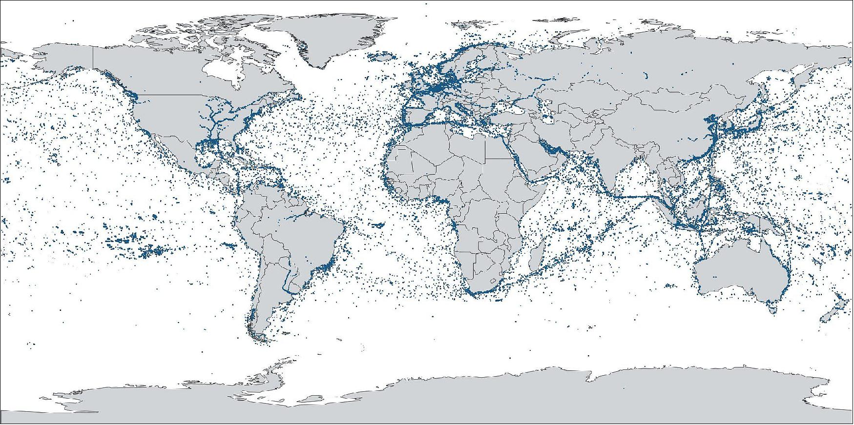
• March 30, 2021: The ESAIL microsatellite for making the seas safer has picked up more than two million messages from 70,000 ships in a single day. 8)
- In the first step, the platform was validated by its Luxembourgish manufacturer, LuxSpace, which involved a number of small and medium-sized European enterprises, that confirmed ESAIL's excellent performance for operational maritime services.
- In the second much more complex step, the data reception and processing of the ships' automatic identification systems were validated by ESAIL's Canadian operator exactEarth. It was during this process that ESAIL captured more than two million messages from 70,000 different ships in a single day, representing 15% to 20% better detection rate than previous satellites.
- The satellite's performance was optimized using adaptive on-board and on-ground processing to maximize the number of ships' messages detected in areas of high traffic, such as the North Sea and South China Sea.
- Its operator exactEarth is now integrating ESAIL into its fleet of satellites, which provide maritime services to customers including fisheries, customs, search and rescue, and environmental protection agencies, as well as the European Maritime Safety Agency.
- Peter Mabson, Chief Executive of exactEarth, said: "ESAIL, with its sophisticated spectrum sampling payload and multipolar antenna capabilities, delivers exceptional vessel detection performance, and we are very pleased to bring this advanced microsatellite into operational service.
- "Our thanks go to ESA and LuxSpace and the entire European satellite manufacturing team for their role in this impressive achievement."
- Oliver Salisch, Managing Director of LuxSpace, said: "LuxSpace is extremely proud of the performance and flexibility exposed by the Triton-2 platform, which has exceeded customer expectations and allowed the optimization of the performance in orbit. This shows the capabilities of LuxSpace to provide effective and reliable technical solutions to customers all over the world.
- "These results were possible due to the extremely fruitful collaboration with ESA and exactEarth in the resolution of the day-to-day challenges."
- The ESAIL project was supported by the Luxembourg Space Agency and other ESA member states.
- Marc Serres, Chief Executive of the Luxembourg Space Agency, said: "This maritime microsatellite, built by Luxembourg's major system integrator LuxSpace in partnership with ESA, demonstrates how a private company and ESA can work closely together to develop a new commercial product.
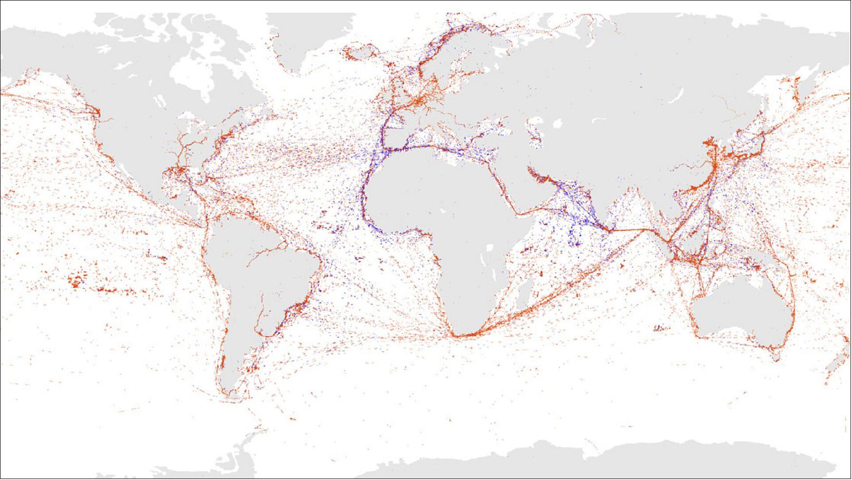
• November 26, 2020: The ESAIL microsatellite for tracking ships at sea has captured 57,000 messages in its first 24 hours of operation, using advanced on-board processing algorithms. 9)
- The high-performance satellite was developed as a Partnership Project to help European and Canadian space companies succeed in the competitive global telecommunications market.
- Launched on 3 September aboard an Arianespace Vega from Europe's spaceport in Kourou, French Guiana, ESAIL has now completed the first phase of its in-orbit commission.
- The satellite makes the seas safer by enabling industry, maritime authorities and governments to monitor fisheries, manage fleets, protect the environment and monitor security.
- It tracks ships worldwide by detecting messages that ships radio-broadcast with their automatic identification systems, enabling them to be identified even when away from coastal-based monitoring stations.
- The satellite was built by LuxSpace under an ESA Partnership Project with the Canadian operator exactEarth. The full team is proud of the impressive first results.
- The project was supported by the Luxembourg Space Agency and other ESA member states.
Passenger Payloads of the Vega Rideshare Mission
Arianespace has realized the first European "rideshare" mission for small satellites, with 53 satellites onboard the Vega launcher for 21 customers from 13 different countries. With this new SSMS (Small Spacecraft Mission Service) shared launch concept, Arianespace demonstrates its ability to respond – in an innovative and competitive manner – to institutional and commercial requirements of the growing market for small satellites. The total satellite launch mass was 1,327 kg. 10)
With the demonstration of its new SSMS service, Arianespace is strengthening its position in the growing market for small satellites. This service will soon be supplemented by the MLS (Multi Launch Service) – a similar offer available on Ariane 6, allowing Arianespace to increase the number of affordable launch opportunities for small satellites and constellations.
• ESAIL is a maritime microsatellite with a mass of 112 kg for AIS (Automatic Identification System) ship tracking operated by exactEarth. Is was built by a European manufacturing team led by the satellite prime contractor Luxspace. ESAIL features an enhanced multiple antenna-receiver configuration for global detection of AIS messages and high-resolution spectrum capture, which will enable the demonstration of advanced future services such as VDES (VHF Data Exchange System) message reception. 11)
• Lemur-2, eight 3U CubeSats built by Spire Global Inc., San Francisco, CA . These satellites carry two payloads for meteorology and ship traffic tracking. The payloads are: STRATOS GPS radio occultation payload and the SENSE AIS payload.
• TriSat is a 3U CubeSat (5 kg) imaging mission led by the University of Maribor, Slovenia. The mission is focused on remote sensing by incorporating a miniaturized multispectral optical payload as the primary instrument, providing affordable multispectral Earth observation in up to 20 non-overlapping bands in NIR-SWIR (Near to Short Wave Infrared) spectrum.
• The launch integrator company Spaceflight Inc. of Seattle WA is providing its services for four different customers with a total of 28 satellites. These are:
a) NewSat-6 (also written as ÑuSat-6), is a low Earth orbit commercial remote sensing microsatellite (43.5 kg) designed and manufactured by Satellogic S.A. with HQs in Argentina, a vertically integrated geospatial analytics company that is building the first Earth observation platform with the ability to remap the entire planet at both high-frequency and high-resolution. This is Satellogic's 11th spacecraft in orbit, equipped with multispectral and hyperspectral imaging capabilities and it will be added to the company's growing satellite constellation.
b) 14 Flock-4v, 3U CubeSats, next-generation SuperDove satellites of Planet Inc., San Francisco, they will join its constellation of 150 Earth-imaging spacecraft.
c) SpaceBEE, 12 (.25U) picosatellites of Swarm Technology which provide affordable global connectivity.
d) Tyvak-0171, an undisclosed minisatellite of Tyvak, developed by Maxar with a mass of 138 kg.
• Planet Inc. of San Francisco launches a total of 26 Flock 4v SuperDoves on this mission. They will be split into two batches on the same launch: 14 of them will be housed inside and deployed from ISL's QuadPack deployers and the remaining 12 will be deployed from D-Orbit's InOrbit Now (ION) freeflying deployment platform. 12)
• Athena, a communications minisatellite mission (138 kg) of PointView Tech LLC, a subsidiary of Facebook. The objective is to provide broadband access (internet connectivity) to unserved and underserved areas throughout the world.
• AMICalSat, a 2U CubeSat, an educational mission, developed by CSUG (University of Grenoble Alpes, France) and MSU-SINP (Lomonosov Moscow State University-Skobeltsyn Institute of Nuclear Physics, Russia). The objective is to take pictures of the Northern light in order to reconstruct the particle precipitation into the polar atmosphere. The payload is a very compact, ultra-sensitive wide filed imager (f=23mm, aperture f/1.4). Firstly, AMICal Sat will observe auroras using nadir pointing, i.e. by determining the center of the Earth to map and link the geographical position of the auroral oval and its internal structures with solar activity. Secondly, the CubeSat will perform image capture ‘in limbo' through tangential orientation with the Earth to capture the vertical profile of the auroras and match an altitude to their various emissions.
• PICASSO, a 3U CubeSat mission (mass of 3.8 kg) developed for ESA ( European Space Agency) led by BISA (Belgian Institute for Space Aeronomy), in collaboration with VTT Technical Research Center of Finland Ltd, Clyde Space Ltd. (UK) and the CSL (Centre Spatial de Liège), Belgium. The goal is to develop and operate a scientific 3U CubeSat.
• GHGSat-C1 of GHGSat Inc., Montreal, Canada, is the first of two nanosatellites (~16 kg) as the commercial follow-on to the GHGSat-D (CLAIRE) demonstration satellite developed and launched by UTIAS/SFL of Toronto in 2016. GHGSat monitors industries greenhouse gas (GHG) and air quality gas (AQG) emissions, including: oil & gas, power generation, mining, pulp & paper, pipelines (natural gas), landfill, chemicals, metals & aluminum, cement, agriculture, and transportation.
• NEMO-HD of SPACE-SI (Slovenian Center of Excellence for Space Sciences and Technologies) is a microsatellite (65 kg) developed at UTIAS/SFL of Toronto, Canada in cooperation with SPACE-SI. The NEMO-HD (Next-generation Earth Monitoring and Observation-High Definition) satellite is a high precision interactive remote sensing mission for acquiring multispectral images and real time HD video.
• FSSCat (Federated Satellite Systems on Cat) is the winner of the 2017 Copernicus Master "ESA Sentinel Small Satellite Challenge (S3)". Proposed by the Universitat Politèctica de Catalunya (UPC) and developed by a consortium composed of UPC (ES), Deimos Engenharia (PT), Golbriak Space (EE), COSINE (NL) and Tyvak International (IT).
• Phi-Sat-1 (Φ-Sat-1) is the first on-board ESA initiative (6U CubeSat) on Artificial Intelligence (AI) promoted by the Φ Department of the Earth Observation Directorate and implemented as an enhancement of the FSSCat mission. Among mission objectives, scientific goals are Polar Ice and Snow monitoring, soil moisture monitoring, terrain classification and terrain change detection (i.e. hazard detection and monitoring, water quality), while technological goals are optical Inter-Satellite Link (OISL) demonstration.
• The RTAFSAT-1 (Royal Thai Air Force Satellite-1) mission, also referred to as NAPA-1, is a 6U CubeSat, the first remote sensing CubeSat mission for Thailand. The satellite will carry out an Earth Observation Demonstration mission with SCS Gecko Camera and Simera TriScape-100 payloads; the designed lifetime is 3 years.
• DIDO-3, a commercial 3U CubeSat mission of SpacePharma. The objective is to gather data by researching the effects of a microgravity environment on biological materials. SpacePharma from Israel will be is on board of SSMS POC with DIDO-3 Nanosatellite to perform biological experiment under Microgravity for several customers involved in pharmaceutical business, supported by Italian Space Agency (ASI) and Israeli Space Agency (ISA). Dido-3 will be monitored from the Ground Station developed by SpacePharma in Switzerland.
• SIMBA (Sun-Earth Imbalance), a 3U CubeSat mission led by the Royal Meteorological Institute Belgium, The objective is to measure the TSI (Total Solar Irradiance) and Earth Radiation Budget climate variables with a miniaturized radiometer instrument. This mission will help in the study of the global warming. This science mission will have a design lifetime of 3 years and the satellite performances will be monitored from ground station located in The Netherlands.
• TARS-1, a 6U CubeSat of Kepler Communications, developed at ÅAC Clyde Space for IoT (Internet of Things) applications. TARS-1 features deployable solar arrays, software defined radios (SDR), a narrowband communications payload and high gain antennas.
• OSM-1 Cicero, the first nanosatellite developed in Monaco by OSM (Orbital Solutions Monaco engineers, a 6U CubeSat with a mass of ~10 kg) based on the Tyvak Nano-Satellite Systems design. OSM plans to build nanosatellites to gather environment and climate data.
• TTU100, a 1U CubeSat developed at the Tallin University of Technology, Estonia. The objective is to test earth observation cameras and high-speed X-band communications. It will perform remote sensing in the visible and IR electromagnetic spectrum.
• UPMSat-2 (Universidad Politecnica de Madrid Satellite-2), a demonstration microsatellite (45 kg) of IRD-UPM.
ION (In Orbit Now) CubeSat Carrier on the Vega SSMS Rideshare Mission
The ION CubeSat carrier is a satellite platform manufactured and operated by D-Orbit (Como, Italy) to carry out InOrbit NOW missions (InOrbit NOW is a service by D-Orbit). It is a complete spacecraft, with its own avionics, electrical and power, attitude control, thermal control, and command and data handling subsystems. Throughout its mission, it can modify its own attitude to accommodate the specific needs of each client. The avionics is designed with high reliability in mind, and all mission-critical subsystems are redundant. The carrier features triple-fault tolerant release commanding subsystems, guaranteeing the release of all CubeSats even in case of failure of the main system. 13)
A 60 cm cubic dispenser provides an internal volume that can accommodate several combinations of 1U, 2U, 3U, 3U+, 6U, 6U+, 12U and 12U+ CubeSats along the vertical axis, until completion of the 48 slots available.
Each tube mounted onboard has its own independent spring release mechanism to guarantee that your CubeSat will be released at the right time and with the right impulse.
References
1) "OHB developing microsatellites for new space market," OHB LuxSpace, 12 September 2017, URL: https://web.archive.org/web/20221224171156/https://luxspace.lu/smaller-lighter-cheaper/
2) "LuxSpace to develop new microsatellite platform," ESA, 23 August 2017, URL:
https://artes.esa.int/news/luxspace-develop-new-microsatellite-platform
3) "ESAIL maritime satellite ready for launch," ESA Applications, 12 June 2020, URL: http://www.esa.int/Applications/Telecommunications_
Integrated_Applications/ESAIL_maritime_satellite_ready_for_launch
4) "ESAIL undergoes its final preparations for launch," ESA, 8 July 2019, URL: http://www.esa.int/Our_Activities/Telecommunications_
Integrated_Applications/ESAIL_undergoes_its_final_preparations_for_launch
5) Arianespace to launch the ESAIL satellite for exactEarth on Vega's SSMS POC flight," Arianespace, 9 May 2019, URL: http://www.arianespace.com/press-release/arianespace-to-
launch-the-esail-satellite-for-exactearth-on-vegas-ssms-poc-flight/
6) "Maritime microsatellite ESAIL to test the waters as launch contract is signed," ESA, 9 May 2019, URL: http://www.esa.int/Our_Activities/Telecommunications_
Integrated_Applications/Maritime_microsatellite_ESAIL_to_test_the_waters_as_launch_contract_is_signed
7) "ESAIL maritime satellite launched," ESA Applications, 3 September 2020, URL: https://www.esa.int/Applications/Telecommunications_
Integrated_Applications/ESAIL_maritime_satellite_launched
8) "ESAIL captures two million messages from ships at sea," ESA Applications, 30 March 2021, URL: https://www.esa.int/Applications/Telecommunications_
Integrated_Applications/ESAIL_captures_two_million_messages_from_ships_at_sea
9) "ESAIL's first map of global shipping," ESA Applications, 26 November 2020, URL: https://www.esa.int/Applications/Telecommunications_
Integrated_Applications/ESAIL_s_first_map_of_global_shipping
10) "With Vega, Arianespace successfully performs the first European mission to launch multiple small satellites," Arianespace Press Release, 3 September 2020, URL: https://www.arianespace.com/press-release/
with-vega-arianespace-successfully-performs-the-first-european-mission-to-launch-multiple-small-satellites/
11) "Vega flight VV16," Wikipedia, URL: https://en.wikipedia.org/wiki/Vega_flight_VV16
12) Mike Safyan, "Planet's First Launch of 2020: 26 SuperDoves on a Vega," Planet, 13 February 2020, URL:
https://www.planet.com/pulse/planets-first-launch-of-2020-26-superdoves-on-a-vega/
13) "ION CubeSat Carrier," URL: https://inorbitnow.space/ion/
The information compiled and edited in this article was provided by Herbert J. Kramer from his documentation of: "Observation of the Earth and Its Environment: Survey of Missions and Sensors" (Springer Verlag) as well as many other sources after the publication of the 4th edition in 2002. - Comments and corrections to this article are always welcome for further updates (eoportal@symbios.space).
Spacecraft Sensor Complement Launch Mission Status ION References Back to top