FY-1 (FengYun-1)
EO
Atmosphere
Ocean
Cloud type, amount and cloud top temperature
Quick facts
Overview
| Mission type | EO |
| Agency | NRSCC, CAST, NSMC-CMA |
| Mission status | Mission complete |
| Launch date | 07 Sep 1988 |
| End of life date | 01 Jun 2012 |
| Measurement domain | Atmosphere, Ocean, Land, Snow & Ice |
| Measurement category | Cloud type, amount and cloud top temperature, Aerosols, Multi-purpose imagery (ocean), Radiation budget, Multi-purpose imagery (land), Surface temperature (land), Vegetation, Albedo and reflectance, Surface temperature (ocean), Sea ice cover, edge and thickness, Snow cover, edge and depth |
| Measurement detailed | Ocean imagery and water leaving spectral radiance, Cloud cover, Aerosol optical depth (column/profile), Cloud imagery, Land surface imagery, Upward long-wave irradiance at TOA, Aerosol effective radius (column/profile), Fire temperature, Fire fractional cover, Earth surface albedo, Land surface temperature, Sea surface temperature, Sea-ice cover, Snow cover, Cloud top temperature, Normalized Differential Vegetation Index (NDVI), Volcanic ash |
| Instruments | MVISR (5 channels), MVISR (10 channels) |
| Instrument type | Imaging multi-spectral radiometers (vis/IR) |
| CEOS EO Handbook | See FY-1 (FengYun-1) summary |
Related Resources
FY-1 (FengYun-1) - 1st Generation Polar Orbiting Meteorological Satellite Series
FengYun (FengYun = wind and cloud) is a meteorological satellite series of China, organized by CMA (China Meteorological Administration). Within the meteorological program, the odd-numbered satellites (FengYun-1 or simply FY-1) refer to the polar-orbiting LEO series, while the even-numbered S/C (FY-2, FY-4, etc.) refer to the GEO series. 1) 2)
The first generation LEO satellite (FY-1) series consists of a total of four spacecraft (FY-1A, -1B, -1C, and -1D). The funding body in China is the Ministry of Aerospace, while CMA (China Meteorological Administration) is the agency authorized and empowered to administer the national meteorological service in the governmental capacity, and is charged with the organizational arrangement and coordination of national meteorological affairs.
NSMC (National Satellite Meteorological Center) is the scientific research and operational facility affiliated to the China Meteorological Administration. The main functions of NSMC include:
• To formulate and draft strategy and development program for China's meteorological satellites (space segment)
• To build up the ground system for China's meteorological satellites
• To conduct scientific research on meteorological satellite and satellite meteorology
• To be responsible for receiving, processing, distribution and application of foreign and China's meteorological satellite data.
NSMC, founded in 1971, maintains facilities to operate and monitor the meteorological satellites of China, to acquire the data of the satellites, and to archive and distribute the meteorological data (general service provision). NSMC operates three ground stations, those of Beijing, Guangzhou, and Urumqi for data acquisition.
The NCC (National Climate Center) of CMA (China Meteorological Administration) was founded in January 1995. NCC is China's national research center responsible for monitoring and assessment of all aspects of climate change. NCC functions also as China's regional WMO climate center. For this reason, CMA created a new entity under NCC supervision, the BCC (Beijing Climate Center), in March 2003.
S/C | Launch | S/C mass | Comment |
FY-1A | Sept. 7, 1988 | 750 kg | S/C suffered attitude control problem after 39 days of operations |
FY-1B | Sept. 3, 1990 | 880 kg | Mission end in late 1992 when the attitude control occurred |
FY-1C | May 10, 1999 | 954 kg | FY-1C operations support exceeded its design life of 2 years. The S/C was retired in January 2004. |
FY-1D | May, 15, 2002 | 954 kg | FY-1D is operational in 2011 |
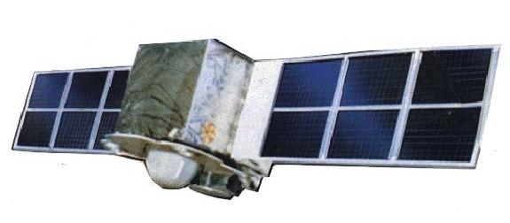
FY-1A/1B (FenYun-1A and -1B Spacecraft)
The FY-1 series satellite program was initiated in 1977. The S/C (FY-1A and FY-1B) were designed and built by the Shanghai Institute of Satellite Engineering, part of CAST (China Academy of Space Technology); their payloads were developed by the Shanghai Institute of Technical Physics (SITP), part of CAS (China Academy of Sciences).
Both S/C are similar in design. The satellite structure is a hexahedron of size: 1.4 m x 1.4 m x 1.2 m and a mass of 750 kg for FY-1A. The FY-1A bus was increased for the FY-1B satellite. Likewise, total spacecraft mass increased from 750 kg to about 880 kg. Both satellites are three-axis stabilized (attitude control is maintained by a combination of nitrogen cold gas thrusters and reaction wheels, attitude is sensed by gyros and horizon sensors) and powered by two solar arrays (about 3.5 m long each) with a combined rating of 800 W. Nickel-cadmium batteries are used for electrical power storage.
Launch
The launch of both S/C was performed by Long March 4 (CZ-4) boosters from Taiyuan, China.
• Launch of FY-1A on September 7, 1988
• Launch of FY-1B on September 3, 1990.
Orbit of FY-1A: Sun-synchronous polar orbit with an altitude of 900 km; inclination = 98.9º, equatorial crossing at 3:30 PM on a descending node, period = 102.86 min.
Orbit of FY-1B: Sun-synchronous polar orbit with an altitude of 900 km; orbital period = 102.86 minutes; inclination = 99.1º, eccentricity < 0.005; equatorial crossing at 7:50 AM.
Operational Status of Missions
• FY-1A (launch Sept. 7, 1988). The S/C went into its predicted orbit and started to make observations on the same day. The imagery was all nominal with an observed SNR higher than the design value. After 39 days of operations, the FY-1A satellite suffered serious malfunctions in its attitude control system and was lost thereafter as a consequence. Another problem was observed on the instrument infrared detectors in form of water vapor contamination, causing the loss of the IR signal.
• FY-1B (launch Sept. 3, 1990). The S/C reached its predicted orbit and provided a considerably improved operations environment on the accuracy and stability of S/C attitude as well as for the observing instruments. However, after operations for half a year, the same attitude problems occurred as with the FY-1A S/C. This time around, ground operations were able to rescue the S/C. Observations were continued until late 1992 when again attitude problems brought the mission to an end.
Sensor Complement
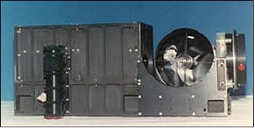
MVISR (Multichannel Visible and IR Scanning Radiometer)
MISR was developed and built by SITP (Shanghai Institute of Technical Physics). 3) 4) 5) Two identical instruments were used on-board each S/C (which operate alternately). The objectives are:
• To acquire global visible and infrared cloud images for weather forecasting
• To take images of the land surfaces for the monitoring of crops, vegetation, snow coverage, floods, etc.
• To measure the sea surface temperature (SST)
• To perform an ocean color experiment for the retrieval of chlorophyll distributions (bands 3 and 4).
MVISR is a five-channel optomechanical scanning instrument operated at 360 rpm. The optical system consists of co-axial and co-focal paraboloid primary mirrors with a 20 cm diameter. The beam splitters of the VIS/IR channels divide the incident radiation into TIR, NIR and VIS beams which are projected onto the respective detectors (HgCdTe, single element Si detector, and three-element Si detector). The optical scanner consists of an elliptical Beryllium-based plane mirror and a driving motor. The mirror rotating axis is 45º. IFOV of 1.2 mrad (1.1 km spatial resolution) in HRPT mode and 4 km resolution in APT mode; FOV=55.4º; swath width = 2,860 km. Instrument calibration of the infrared channels is provided by a reference blackbody and by cold-space views in each scan period. The calibration parameters are transmitted as part of every data record. The TIR detector (HgCdTe) is operated at 105 K (cooled by a radiation cooler).
Channel | Wavelength (µm) | Objectives/Primary Use | |||
1 | 0.58 - 0.68 | Daytime cloud and surface imaging | |||
2 | 0.725 - 1.10 | Daytime cloud image and water, ice, snow, and vegetation observation | |||
3 | 0.48 - 0.53 | Ocean color imaging | |||
4 | 0.53 - 0.58 | Ocean color imaging | |||
5 | 10.5 - 12.5 (TIR) | Diurnal cloud image surface observation and sea surface temperature | |||
Communications in real-time. Capability of on-board data storage. The satellites provided data in three modes: HRPT (High Resolution Picture Transmission) at 665.4 kbit/s, APT (Automatic Picture Transmission), and DPT (Delayed Picture Transmission). The data formats of HRPT and APT are very similar to those of the NOAA series satellites (satellite attitude is included).6)
The FY-1 series ground segment consists of three ground stations located in Beijing, Guangzhou and Urumqi; a data processing center is at NSMC (National Satellite Meteorological Center). NSMC broadcasts the FY-1 orbital prediction via GTS so that users throughout the world may receive HRPT and APT data in real time. 7)
Carrier Frequency | Data Rate | Modulation Mode | Power |
HRPT: 1695.5, 1704.5 MHz | 0.6654 Mbit/s | PCM/PSK | 5 W |
APT: 137.035, 137.795 MHz | 2.4 kHz | AM/FM | 8 W |
FY-1C/1D (FengYun-1C and FengYun-1D Spacecraft)
The FY-1C/1D spacecraft are upgraded versions of the FY-1B satellite. A major effort has been made to improve the S/C reliability. The satellite structure is a hexahedron with body dimensions of 1.42 m x 1.42 m x 1.2 m. The deployed length of the S/C is 10.5 m. There are two solar panels, each with a total collecting area of 9.58 m2 providing power of 250 W. The S/C is three-axis stabilized with a pointing accuracy of 0.4º. Two MVISR instruments (one redundant) are mounted on the nadir-facing side of the S/C. The S/C mass is 954 kg, the S/C design life is two years. 8) 9) 10) 11) 12) 13)
RF Communication
The High Resolution Picture Transmission mode of FY-1C and FY-1D is named CHRPT (China HRPT or simply HRPT), implemented in S-band. The data rate of CHRPT is 1.3308 Mbit/s, the modulation is BPSK/Bi-phase,m the polarization is right hand circular, the EIRP = 39.4 dbm. The transmission frequency is 1700.5 MHz. The data format is very similar to that of HRPT of the NOAA satellites. The on-board data storage capacity is increased to 300 minutes of data take (compared to 60 minutes on FY-1A/1B). This offers the provision of a parallel (to CHRPT) low-rate data stream, once per day, of four selected channels with reduced resolution (3.1 km) data, the low-rate transmission rate is 88.72 kbit/s. The low-rate data is referred to as GDPT (Global Delayed Picture Transmission), while the ten-channel data with 1.1 km resolution from anywhere in the world is referred to as LDPT (Local Delayed Picture Transmission). There is no support provided for APT mode communications.
No of words/frame | 22180 |
No of channels | 102,048 words/channel |
Frame rate | 6 frame/s |
No of bits/word | 10 bit/word |
Data rate | 1.3308 Mbit/s |
The China National Satellite Meteorological Center (NSMC) receives the CHRPT data in Beijing, Guangzhou and Urumqi ground receiving stations in real time. In addition, NSMC can receive global coverage data through four selected channels with reduced resolution (4 km) once per day (DGPT data), as well as 20 minutes orbit observation data through ten channels with original resolution at any region of the world.
Spacecraft launch mass, average power | 954 kg, 256 W |
S/C height | 2.115 m (solar sailboard included) |
Spacecraft stabilization | 3-axis stabilized |
Spacecraft design life | 2 years |
Launch
FY-1C was launched May 10, 1999 [along with the science exploratory satellite named Shi Jian-5 (SJ-5)] on a CZ-4B vehicle from the Taiyuan launch site, China. 14) 15)
FY-1D's launch took place on May 15, 2002 from the Taiyuan Satellite Launch Center, along with Haiyang-1 (Ocean-1) on a LM-4B launch vehicle.
Orbit: Sun-synchronous polar orbit, altitude = 863 km, inclination = 98.79º, period = 102.3 minutes, eccentricity <0.005, the repeat period is 12 days. The local equatorial crossing time is for FY-1C and FY-1D is around 7 and 9 AM, respectively, on the descending node.
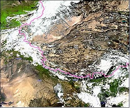
Some application examples of FY-1C and 1D data: Drought monitoring, snow cover and snow disaster monitoring, flood monitoring, forest and grassland fire monitoring, dust storm monitoring, sea ice monitoring, etc.
Operational Status of Missions
• The FY-1D spacecraft and its payload are operating nominally in 2011. 16)
• In October 2010, the FY-1D spacecraft and its payload (MVISR) are operational. 17)
• The FY-1D spacecraft is operational in 2009.
• On Jan. 11, 2007, China destroyed the FY-1C spent/inactive satellite in an interception test causing an explosion and a lot of debris in a wide LEO corridor . Some 40 pieces of debris have been tracked and cataloged by NORAD. Some of these pieces have apogees as high as 3,500 km. As more and more debris is “discovered” it will be clear that more and more of space is threatened. However, even the debris already tracked will start to spread out with time and threaten more and more satellites.
According to press reports, the interceptor is believed to have been carried by a DF-21 IRBM (known as in the West as the CSS-5), a solid propellant, two stage missile of the Chinese Armed Forces. This test makes China the third country, after the USA and Russia, to have tested ASAT (Anti Satellite) weapons. For China, the interception test was a successful military technology demonstration. However, for the rest of the world, the interception test caused many concerns with regard to space debris spreading in the densely populated LEO environment; the test generated a lot of protest from all spacefaring nations. 18) 19) 20)
• The MVISR instrument of FY-1C spacecraft experienced a scanner synchronizing problem in January 2004, thereby ending the operational life of the instrument. The FY-1C spacecraft was decommissioned in late 2005. - Nominal operations are provided by the FY-1D spacecraft and instruments. 21)
Sensor Complement
MVISR (Multichannel Visible and IR Scanning Radiometer)
MVISR was developed and built by SITP (Shanghai Institute of Technical Physics). MVISR is composed of the following elements: optical scanner, image information processor, radiant cooler and cooler controller. The upgraded MVISR is now a 10-channel instrument (the total number of bands was doubled for the -1C and -1D instruments form the previous -1A and -1B instruments).
The optomechanical instrument (whiskbroom scanning technique) has a scan mirror with a rotation rate of 360 rpm. The aperture of the optical system is 200 mm in diameter. The IFOV = 1.2 mrad, the nadir resolution of all channels is 1.1 km. The instrument FOV is ±55.4º (2800 km swath). The scan rate of MVISR is 6 lines/s, the total number of pixels of every scan line is 2048.
Band No | Spectral Range (µm) | Primary use of data |
1 | 0.58 - 0.68 (VIS) | Daytime clouds, ice and snow, vegetation |
2 | 0.84 - 0.89 (VNIR) | Daytime clouds, vegetation, water |
3 | 3.55 - 3.93 (MWIR) | Heat source, night cloud |
4 | 10.3 - 11.3 (TIR) | SST, day/night clouds |
5 | 11.5 - 12.5 (TIR) | SST, day/night clouds |
6 | 1.58 - 1.64 (SWIR) | Soil humidity, provision of ice/snow cover distinguishing capability |
7 | 0.43 - 0.48 (VIS) | Ocean color |
8 | 0.48 - 0.53 (VIS) | Ocean color |
9 | 0.53 - 0.58 (VIS) | Ocean color |
10 | 0.90 - 0.965 (VNIR) | Water vapor |
Instrument type | Whiskbroom scanning radiometer |
Optical aperture of telescope | 200 mm |
IFOV (Instantaneous Field of View) | 1.26 mrad (1.1 km spatial resolution) |
Detector material | Si detector for bands 1,2, 7, 8, 9, 10 HgCdTe for bands 3, 4, 5 and 6 |
Cooler | Radiant cooler operating at 105 K |
Radiometric sensitivity | NEDR < 3 x 10⁻⁴, bands 1, 2, 7, 8, 10 |
Radiation calibration accuracy | >10% for VIS and IR bands, 1.0 K for TIR bands |
Scan rate | 6 lines/s (or 360 rpm) |
Pixels per scan line | 2048 for CHRPT and LDPT data |
Data quantization | 10 bit |
Instrument mass, power | 55 kg, 45 W |
HEPD (High Energy Particle Detector)
The objective is to study the space environment: measurements include heavy ions composition, proton energy spectrum and high energy electron integrated flux. The detector was built by CSSAR (Center for Space Sciences and Applied Research) of CAS (Chinese Academy of Sciences). The detector can measure protons in the energy range from 4 to 300 MeV and electron flux of over 2 MeV in the Earth's inner radiation belt. CAS uses the space weather data to issue solar storm warnings, which are very useful in protecting orbiting spacecraft and in various terrestrial applications such as surge protection of a power grid.
References
1) W. Zhang, “Meteorological satellite program of China,” Proceedings of SPIE, Vol. 3501, Optical Remote Sensing of the Atmosphere and Clouds, Sept. 15-17, 1998, Beijing, China, pp. 12-22
2) W. Zhang, “Meteorological satellite program of China;” Proceedings of ACRS (Asian Conference on Remote Sensing) 1999, Hong Kong, China, Nov. 22-25, 1999
3) H. Gong, Q. Zheng, W. Wang, “The Improvement of the Detecting Property and the Performance of the Very High Resolution Scanning Radiometer on FY-1B Meteorological Satellite,” AAS 91-658, pp. 497-503
4) SITP internal paper written by D. Kuang,, H. Gong, and Q. Zheng
5) Q. B. Zheng, X. R. Xue, “Optical Design of the Remote Sensing Instrument for FY-1 Meteorological Satellite,” Chinese Journal of Infrared & Millimeter Waves, Volume 9, Number 2, 1989
6) `The Data Format and the calibration Parameters of FY-1 Meteorological Satellite,' Satellite Meteorology Center, SMA
7) Ch. Weng, et al, “Remote Sensor on the FY-1 Satellite”, Paper IAF-92-099, 43rd Congress of the International Astronautical Federation, August-September 1992
8) X. Jianping, W. Caiying, “The Chinese Meteorological Satellite Programs,” Proceedings of the 2000 EUMETSAT Meteorological Satellite Data Users' Conference, Bologna, Italy, May 29 - June 2, 2000, pp. 168-173
9) Gong Huixing, Zheng Qinbo, Weng, Chuijin, “The FY-1C Meteorological Satellite and its Remote Sensor,” Proceedings of the Asian Conference on Remote Sensing, Hongkong, Nov. 22-25, 1999, pp. 1253-1257
10) Y. Liu, W. Zhang, Y. Zongdong, “FY-1C Polar Orbiting Meteorological Satellite of China: Satellite Ground System and Preliminary Applications,” Proceedings of the Asian Conference on Remote Sensing, Hongkong,, Nov. 22-25, 1999, pp. 1261-1267
11) S. Weimin, “The Chinese FY-1 Meteorological Satellite Application in Observation on Oceanic Environment,” Proceedings of the 34th COSPAR Scientific Assembly, The Second World Space Congress, held 10-19 Oct. 10-19, 2002, Houston, TX, USA
12) W. Zhang, C. Dong, J. Xu, J. Yang, “Current and Future Meteorological Satellite Program of China,” 2005, URL: http://cimss.ssec.wisc.edu/itwg/itsc/itsc14/presentations/session9/9_2_zhang.pdf
13) C. Dong, W. Zhang, “China's Current and Future Meteorological Satellite Systems,” The 2004 EUMETSAT Meteorological Satellite Conference, May 31-June 4, 2004, Prague, Czech Republic, URL: http://www.eumetsat.int/Home/Main/Publications/Conference_and_Works...
14) Information provided by Wang Xinmin of the Shanghai Institute of Technical Physics, Shanghai
15) T. Pirard, “Earth Observation Technology”, Spaceflight, January 1995, pp. 20-21
16) http://www.nsmc.cma.gov.cn/NewSite/NSMC_EN/Channels/100190.html
17) CEOS EO Handbook, Oct. 2010, NRSCC agency summary, URL: http://database.eohandbook.com/database/agencysummary.aspx?agencyID=20
18) G. Forden, “A Preliminary Analysis of the Chinese ASAT Test,” URL: http://web.mit.edu/stgs/pdfs/A%20Preliminary%20Analysis%20of%20the...
19) J. Oberg, “The dozen space weapons myths,” March 12, 2007, URL: http://www.thespacereview.com/article/826/1
20) D. Anderson, “Space preservation or space destruction?,” March 12, 2007, URL: http://www.thespacereview.com/article/825/1
21) Information provided by Chaohua Dong of CMA/NSMC (National Satellite Meteorological Center), Beijing
The information compiled and edited in this article was provided by Herbert J. Kramer from his documentation of: ”Observation of the Earth and Its Environment: Survey of Missions and Sensors” (Springer Verlag) as well as many other sources after the publication of the 4th edition in 2002. - Comments and corrections to this article are always welcome for further updates(eoportal@symbios.space).