FY-4 (FengYun-4)
EO
Atmosphere
Ocean
Cloud type, amount and cloud top temperature
FengYun-4 (FY-4) is a series of seven geostationary meteorological satellites, owned and operated by the China Meteorological Administration (CMA), the first of which, designated FY-4A, was launched in December 2016. As of December 2022, three FY-4 satellites are operational, with the rest still under development by the China Academy of Space technology (CAST). FengYun-4’s mission objectives include imagery, sounding, lightning mapping, and space environment monitoring.
Quick facts
Overview
| Mission type | EO |
| Agency | NRSCC, NSMC-CMA |
| Mission status | Operational (nominal) |
| Launch date | 31 Dec 2015 |
| Measurement domain | Atmosphere, Ocean, Land, Gravity and Magnetic Fields |
| Measurement category | Cloud type, amount and cloud top temperature, Atmospheric Temperature Fields, Multi-purpose imagery (ocean), Multi-purpose imagery (land), Surface temperature (land), Albedo and reflectance, Gravity, Magnetic and Geodynamic measurements, Surface temperature (ocean), Atmospheric Humidity Fields, Trace gases (excluding ozone), Ocean surface winds, Atmospheric Winds, Lightning Detection |
| Measurement detailed | Ocean imagery and water leaving spectral radiance, Cloud cover, Cloud imagery, Land surface imagery, Earth surface albedo, Atmospheric specific humidity (column/profile), Atmospheric temperature (column/profile), Land surface temperature, Sea surface temperature, Wind vector over sea surface (horizontal), NO2 Mole Fraction, NO (column/profile), Ion Density, Drift Velocity, and Temperature, Total lightning density, Wind vector over land surface (horizontal) |
| Instruments | GIIRS, AGRI, LMI, SEP |
| Instrument type | Imaging multi-spectral radiometers (vis/IR), Space environment, Atmospheric temperature and humidity sounders, Lightning sensors |
| CEOS EO Handbook | See FY-4 (FengYun-4) summary |
Summary
Mission Capabilities
The sensor complement for the FY-4 missions consists of four instruments: the Advanced Geosynchronous Radiation Imager (AGRI), the Geostationary Interferometric Infrared Sounder (GIIRS), the Geostationary Lightning Imager (GLI), also known as the Lightning Mapping Imager (LMI), and the Space Environment Monitoring Package (SEP). AGRI is a multispectral imager, with two-axis scanning geometry, and aims to provide multi-purpose imagery, as well as wind derivation. GIIRS is a MWIR (Mid-Wave Infrared)/TIR (Thermal Infrared) sounder, and the main payload of the mission, that aims to monitor and measure internal constitution and precipitation parameters of atmospheric cloud clusters. GLI is a CCD (Charge Coupled Device) camera, which aims to count lightning flashes and record their intensity. Finally, SEP is a group of instruments, including a Flux Gate Magnetometer (FGM), radiation dosimeter and surface charging sensors, that aims to monitor charged particles at the platform level.
Performance Specifications
AGRI operates in 14 spectral bands, with bandwidths of 0.45 µm - 13.8 µm. The spatial resolution ranges from 0.5 - 4 km, depending on the spectral band used. GIIRS has a spectral range of 0.55 - 14.3 µm, with spatial resolutions of 2 - 16 km. GLI has a spatial resolution of 7.8 km and a temporal resolution of 2 seconds.
The FY-4 series will all operate in a geostationary orbit, with each satellite at one of two positions, 86.5°E or 105°E.
Space and Hardware Components
The FY-4 series will use the SAST-5000 bus, designed and developed by the China Aerospace Science and Technology Corporation (CASC) and the Shanghai Academy of Space Technology (SAST). The bus has a launch mass of approximately 5300 kg and features an attitude determination system consisting of star trackers, inertial measurement systems and reaction wheels for attitude actuation. The bus has a design life of 7 years. Raw data downlink is carried out in X-band.
FY-4 (FengYun-4) Geostationary Meteorological Satellite Series
Spacecraft Launch Mission Status Sensor Complement Ground Segment References
FY-4 is CMA's (China Meteorological Administration) second-generation three-axis stabilized, geostationary meteorological satellite series, under development by CAST (China Academy of Space Technology). Two variants of spacecraft of the FY-4 (FenYun means "winds and clouds or storm" in Chinese) program are in planning, with one carrying optical sensors and the other carrying microwave sensors.
Compared to the current FY-2 geostationary meteorological satellite series, the performance of the FY-4 series has been considerably improved in terms of data amount, network transmission bandwidth, product type and quantity and archiving data and applications. The new generation FY-4 satellites are designed with an enhanced imagery scanning capability, desirable for monitoring small and medium scale weather systems. FY-4 is enabled with vertical atmospheric sounding and microwave detection capabilities to address 3D remote sensing at geostationary altitudes. The new FY-4 series is also enabled with solar observations for EUV (Extreme Ultraviolet) and X-ray monitoring, in a bid to enhance China's space weather watch and warning capability. 1)
Based on user requirements and technical feasibility, the missions of the FY-4 series include imagery, sounding, lightning mapping, and space environment monitoring. HRIT (High Rate Information Transmission), LRIT (Low Rate Information Transmission) data transmission, and DCP (Data Collection Platform) services are available for users. 2) 3) 4) 5)
In 2015, the Chinese government approved the NSIP (National Space Infrastructure Plan) covering also the meteorological program of LEO and GEO missions up to 2025. 6)
The geostationary FenYun-4 series consists of seven spacecraft:
• FY-4A (2016-2021)
• FY-4B (2018-2025)
• FY-4C (2020-2027)
• FY-4D (2023-2030)
• FY-4E (2027-2034)
• FY-4F (2030-2037)
• FY-4G (2033-2040)
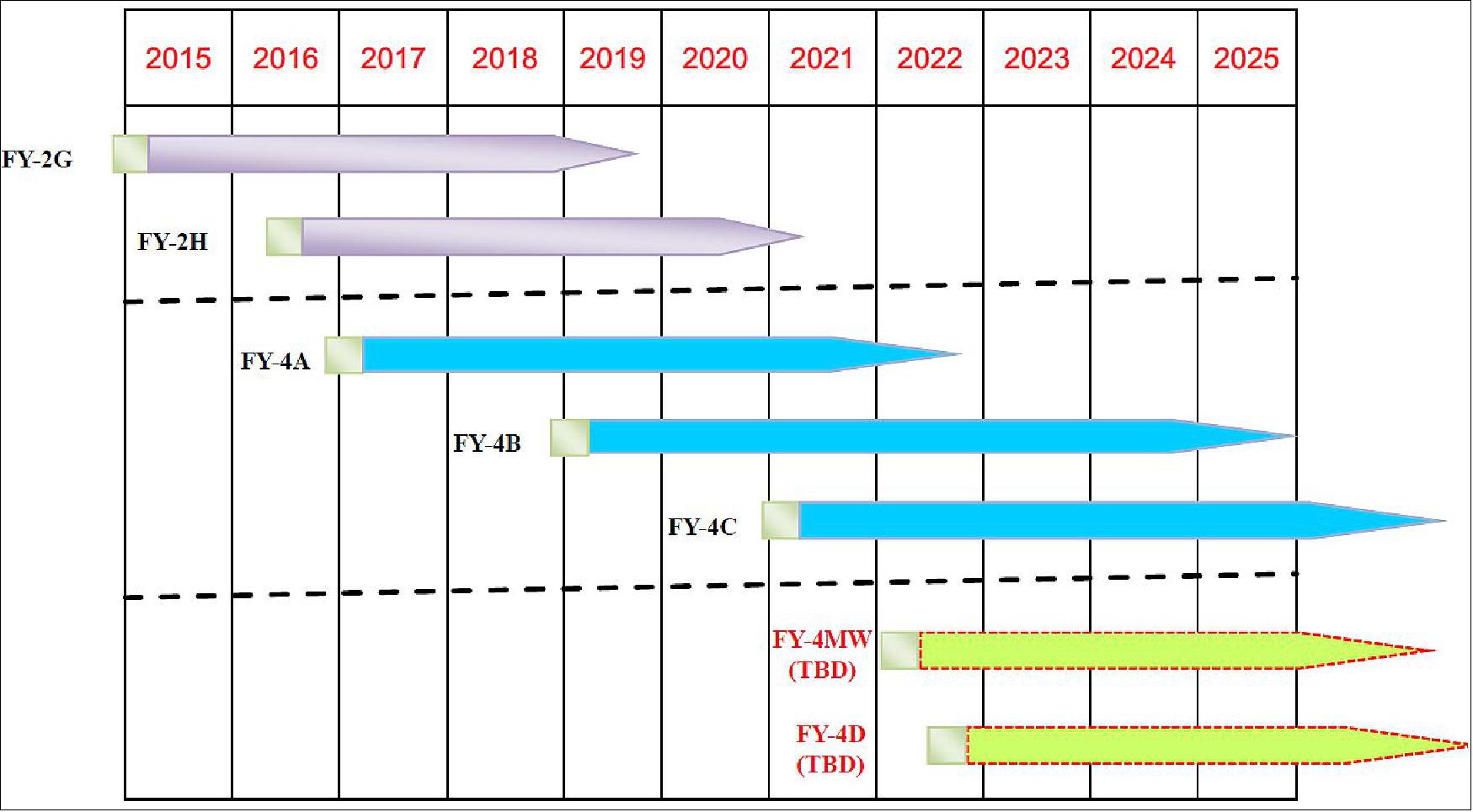
Next to the first FY-4 missions with optical payloads, CMA is also planning for FY-4 missions with MW (Microwave) payloads as shown in Figure 1.
FY-4 Optical Series
The optical variant will include two satellites: FengYun-4 ‘East', which will cover a region including western China, the Indian Ocean, the Red Sea and the Middle East; and FengYun-4 ‘West', which will cover a region including middle and eastern China and the Pacific. The microwave variant FengYun-4 will cover China and its peripheral areas. The FY-4A mission is considered a pre-operational (pathfinder, or R&D) mission with the follow-on FY-4B, -4C spacecraft are considered operational missions. 7) 8) 9) 10) 11) 12) 13)
The main tasks are described as follows:
- a) To obtain the multi-spectrum and high-accurate quantitative images of the earth and clouds;
- b) To measure the humidity parameter of atmosphere;
- c) To enhance the ability of detecting the space weather and environment;
- d) To collect various earth environmental parameter;
- e) To broadcast images, weather products, and the devastating weather forecasting.
Parameter | FY-4 spacecraft series | FY-2 spacecraft series |
Spacecraft stabilization | Three-axis stabilized | Spin stabilized |
Spacecraft design life | 5-7 years | 4 years |
Observation efficiency | 85% | 5% |
Observation capabilities | Imaging +Sounding + Lightning Mapping | Imaging only |
Main instruments | AGRI (Advanced Geosynchronous Radiation Imager) | VISSR (Visible and Infrared Spin-Scan Radiometer) |
GIIRS:(Geostationary Interferometric Infrared Sounder) | N/A (Not Applicable) | |
LMI(Lightning Mapping Imager) | N/A | |
SEP(Space Environment Package) | SEM (Space Environment Monitor) |
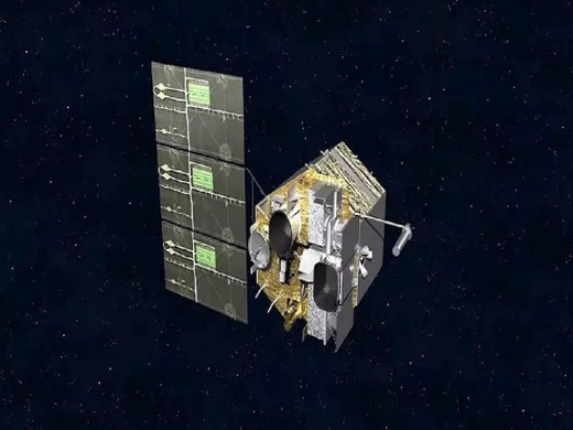
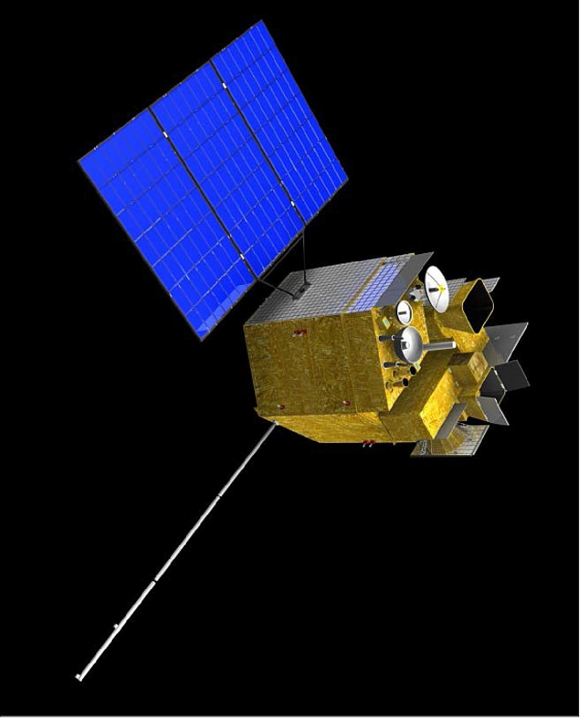
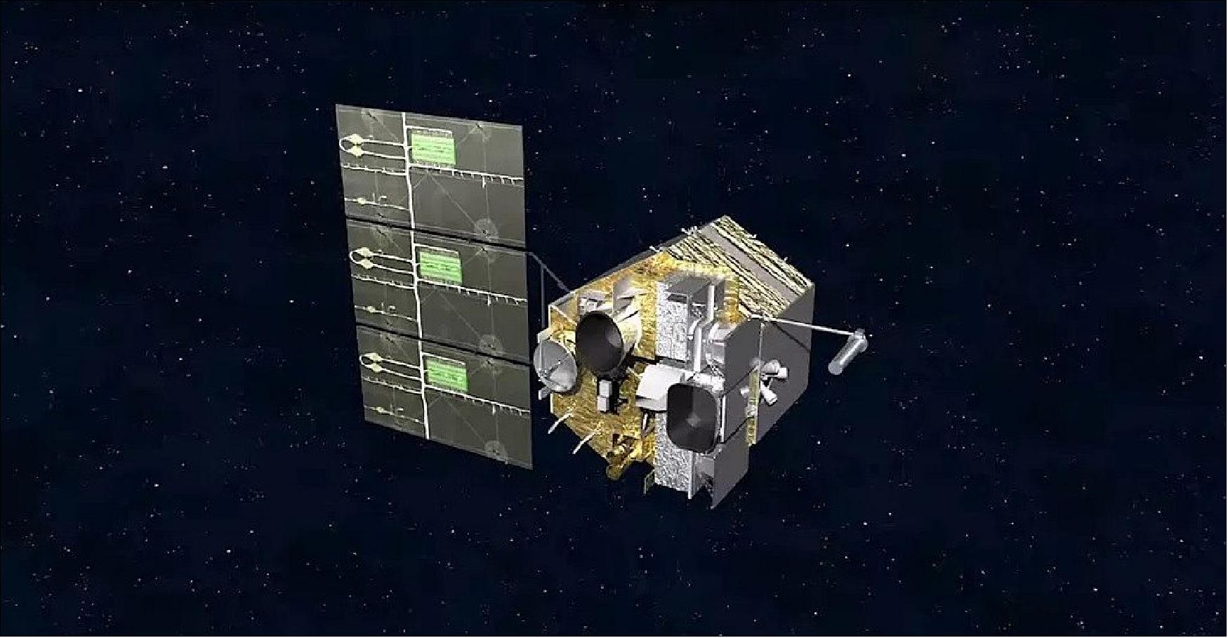
Spacecraft
The FY-4 series of geostationary spacecraft are being designed and developed by CASC/SAST (China Aerospace Science and Technology Corporation/Shanghai Academy of Space Technology). The SAST-5000 bus features an attitude determination system relying on star trackers, inertial measurement systems and Earth/Sun sensors with reaction wheels acting as the primary attitude actuator, achieving a high pointing accuracy of 3arcsec at low jitter to keep the satellite in a precise Earth-pointed attitude. Internal communications on the satellite use the 1553B communications standard and high-speed SpaceWire which supports the data rates required by the instruments and allows for easy integration. Downlink of raw instrument data is completed in real time via a high-speed X-band terminal operating at 7.500 GHz.
1) Launch mass: ~5300 kg
2) Spacecraft stabilization: Three-axis stabilization
3) Attitude accuracy: 3 arcsec
4) Onboard communication bus: 1553B+SpaceWire
5) Raw data transmission : X-band
6) Output power: ≥ 3.2 kW
7) Spacecraft design life: 7 years.

Orbit: Geostationary orbit, altitude = 35786 km, longitude = 104.7º E. The FY-4A satellite re-located from the initial position (99.5°E) to the current operational position (105°E nominal) on 16 April 2018.
Launch
The FY-4B GEO weather satellite was launched on June 02, 2021 (17:29 UTC) (~5300 kg) of China (CMA) on a CZ-3B vehicle from LC-2 at XSLC (Xichang Satellite Launch Center). 16)
Orbit: Geostationary orbit, altitude = 35786 km, longitude = 123.5º E.
The FY-4B satellite will be the first operational launch of the second-generation geostationary satellite. The FY-4B satellite carries the same suite of four instruments as FY-4A, which will gather data to help forecasters studying weather systems on Earth as well as helping to study and predict space weather.
According to CMA, Fengyun-4B adds new water vapor detection channels in its radiation imager, improved spectrum detection capabilities, and is capable if providing more accurate atmospheric radiation and temperature and humidity profiles. CMA said Fengyun-4B also has a "newly equipped fast imager" with a resolution of about 250 meters, to better monitor typhoons, rainstorms, and other extreme weather events. Fengyun-4B also has an improved data download system using Ka-band communications. 17)
Like other satellites in China's meteorological observatory fleet, Fengyun-4B data will be shared with international users, Chinese officials said.
"The measurement resolution and measurement sensitivity of the Fengyun-4B satellite are both doubled compared with the Fengyun-4A satellite, which can better serve meteorological forecasts," said Dong Yaohai, the chief designer of the Fengyun 4 satellite series, in a statement released by the China Aerospace Science and Technology Corp.
Fengyun 4B will undergo a seven-month in-orbit test campaign before entering operational service, CMA said.
The new Fengyun-4 satellite series replaces China's previous family of Fengyun-2 geostationary weather satellites.
Mission Status
• July 7, 2021: The FY-4B satellite is in the commissioning phase. 18) — The FY-4A satellite is operational.
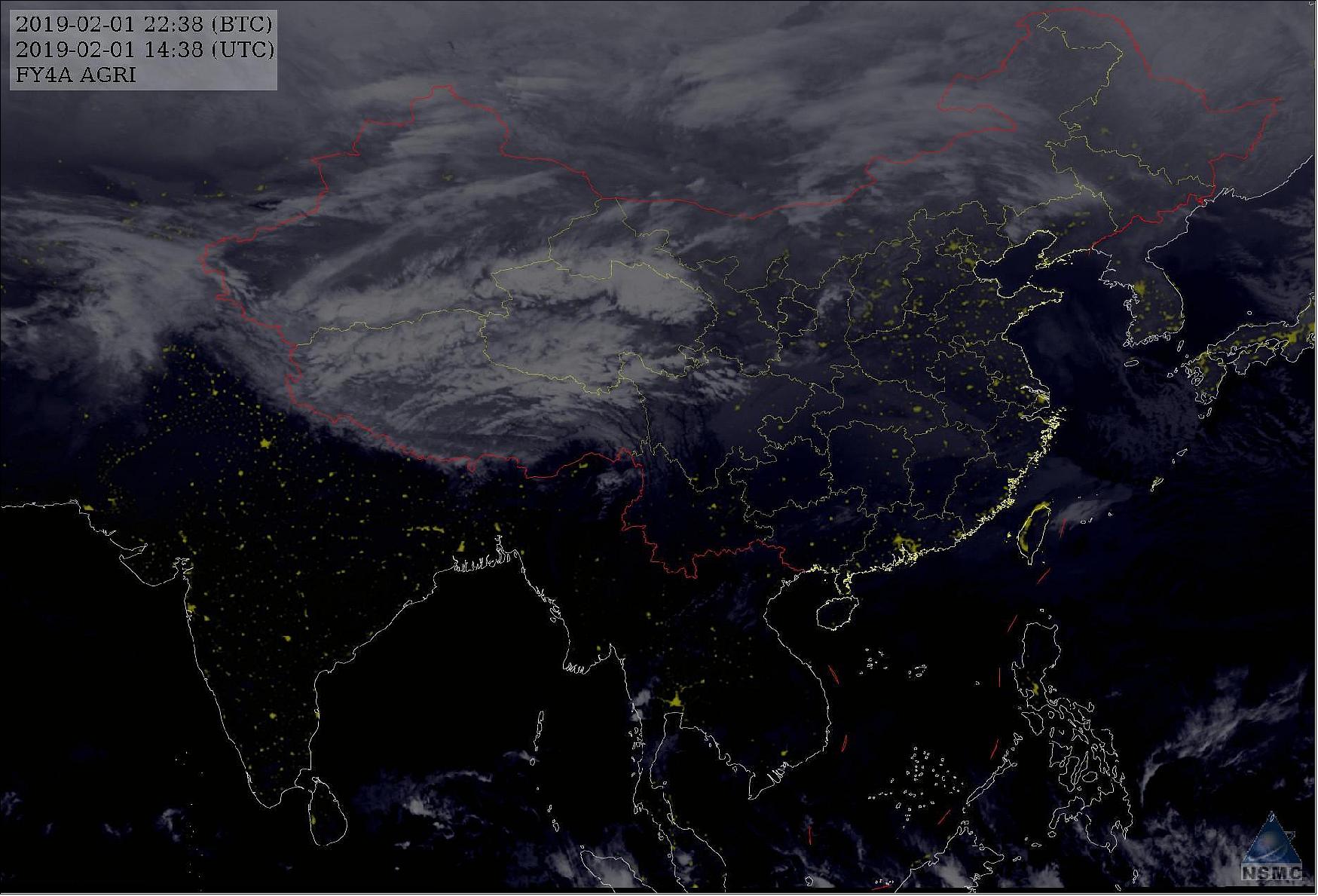
• February 1, 2019: The FengYun-4A is fully operational providing imagery to CMA and their partners. 19)
• June 2, 2018: The FY-4A satellite is operating nominally. 20)
- FY-4A has been operational from May.8, 2018
- The post launch test for satellite was finished on Dec.31,2017.
• February 28, 2017: FengYun-4A, the first of China's second-generation geostationary orbiting weather satellites, has sent its first collection of images and data. SASTIND (State Administration of Science, Technology and Industry for National Defence) and CMA (China Meteorological Administration) published the images and data on Feb. 27, signaling the successful upgrade of China's meteorological system. 21) 22)
- The composite image of Figure 5 was acquired by the instruments AGRI (Advanced Geosynchronous Radiation Imager) and GIIRS (Geostationary Interferometric Infrared Sounder).
- "We achieved a very successful engineering development. Four major payload devices of the FengYun-4 satellite started up smoothly and captured the first batch of data. The quality of the images is great. The information gained is up to what is expected in terms of quality and is qualified for use," said Tian Yulong, chief engineer of SASTIND.
Sensor Complement
The sensor complement of the new generation satellites are designed with an enhanced imagery scanning capability, desirable for monitoring small and medium scale weather systems. It is enabled with vertical atmospheric sounding and microwave detection capabilities to address 3D remote sensing at high altitudes. It is also enabled with solar observations for extreme ultraviolet and X-rays, in a bid to enhance China's space weather watch and warning capability. 23) 24)
AGRI (Advanced Geosynchronous Radiation Imager)
AGRI uses an off-axis telescope, two scan mirrors, 216 detectors in 14 spectral bands, and full-path on-orbit calibration. 25)
Channel | Band (µm) | Spatial resolution (km) | Sensitivity | Application |
VNIR (Visible&Near Infrared) | 0.45-0.49 | 1 | S/N ≥ 90 | Aerosols |
0.55-0.75 | 0.5-1 | S/N ≥ 200 | Clouds, Fog | |
0.75-0.90 | 1 | S/N ≥ 200 | Vegetation | |
SWIR (Shortwave Infrared) | 1.36-1-39 | 2 | S/N ≥ 200 | Cirrus |
1.58-1.64 | 2 | S/N ≥ 200 | Cloud, Snow | |
2.10-2.35 | 2-4 | S/N ≥ 200 | Cirrus, Aerosol | |
MWIR (Midwave Infrared) | 3.5-4.0 (high) | 2 | NEDT ≤ 0.7 K | Fire |
3.5-4.0 (low) | 4 | NEDT ≤ 0.2 K | Land Surface | |
Water Vapor | 5.8-6.7 | 4 | NEDT ≤ 0.3 K | Water Vapor |
6.9-7.3 | 4 | NEDT ≤ 0.3 K | Water Vapor | |
LWIR (Longwave Infrared) | 8.0-9.0 | 4 | NEDT ≤ 0.2 K | Water Vapor, Cloud |
10.3-11.3 | 4 | NEDT ≤ 0.2 K | Sea Surface Temperature | |
11.5-12.5 | 4 | NEDT ≤ 0.2 K | Sea Surface Temperature | |
13.2-13.8 | 4 | NEDT ≤ 0.5 K | Cloud, Water Vapor |
Legend to Table 2: S/N (Signal to Noise Ratio) is specified at 100% albedo, NEDT is specified at 300 K, except for the two water vapor channels, which are specified at 260 K. 26) 27)
AGRI is replacing the S-VISSR sensor, flown on the FY-2A to H series. AGRI is the primary instrument of FY-4A, has 14 channels and two observation modes. The temporal resolutions are 1 - 5 minutes over a regional domain and 15 minutes over the full-disk domain.
AGRI is a multispectral imager with a two-axis scanning geometry, vastly expanding previous capabilities by adding spectral channels, improving spectral and spatial resolution of imagery, and employing a much faster data acquisition scheme.
GIIRS (Geostationary Interferometric Infrared Sounder)
GIIRS, developed by National Space Science Center of CAS, will be the main payload on board of FY-4A satellite to monitor and measure internal constitution and precipitation parameters of the atmosphere cloud cluster. 28)
Parameters | FY-4A (R&D) | FY-4B (Operational) |
Spectral parameters (normal mode) | Range Resolution Channels | Range Resolution Channels |
Spatial resolution | LWIR/S/MWIR : 16 km SSP (Sub-Satellite Point) | LWIR/S/MWIR : 8 km SSP |
Operational mode | China area: 5000 km x 5000 km | China area: 5000 km x 5000 km |
Temporal resolution | China area < 1 hr | China area < 1 hr |
Sensitivity (mW/m2 sr cm-1) | LWIR: 0.5 -1.1 | LWIR: 0.3 |
Calibration accuracy | 1.5 K (3σ) radiation | 1.0 K (3σ) |
Calibration accuracy | 10 ppm (3σ) spectrum | 5 ppm (3σ) |
Data quantization | 13 bit | 13 bit |
GIIRS can be used for vertical atmospheric sounding and it is the first high-resolution sounding sensor onboard the geostationary satellite. There are two observation modes of GIIRS. One mode is designed for China area, whose temporal resolution is 55 minutes and the coverage is 4500 x 4500 km. The other observation mode is mesoscale mode, whose temporal resolution is 30 minutes and the coverage is 1000 x 1000 km.
GIIRS is a MWIR (Mid-Wave Infrared)/TIR (Thermal Infrared) sounder with large detector arrays for simultaneous sounding of a larger area plus visible coverage support for cloud detection. The instrument operates by stepping dual scanning mirrors to subsequent scan positions with a specific dwell time over each location for data acquisition. On FY-4A, GIIRS covers 538 TIR channels and 375 MWIR channels, to be expanded to 1,188 detectors on the operational missions of FY-4B and forward.
The GIIRS detectors employ a deep data quantization of 13 bit and active coolers keep the 32 x 4 focal plane at a constantly low temperature for dark current reduction.
Data delivered by GIIRS is used to for atmospheric temperature profiles, cloud top height and temperature, sea surface temperature, specific humidity profiles, integrated water vapor measurements, cloud cover maps, land surface temperature, horizontal winds, total column ozone, and cloud type discrimination.
GLI (Geostationary Lightning Imager) — also called LMI (Lightning Mapper Imager)
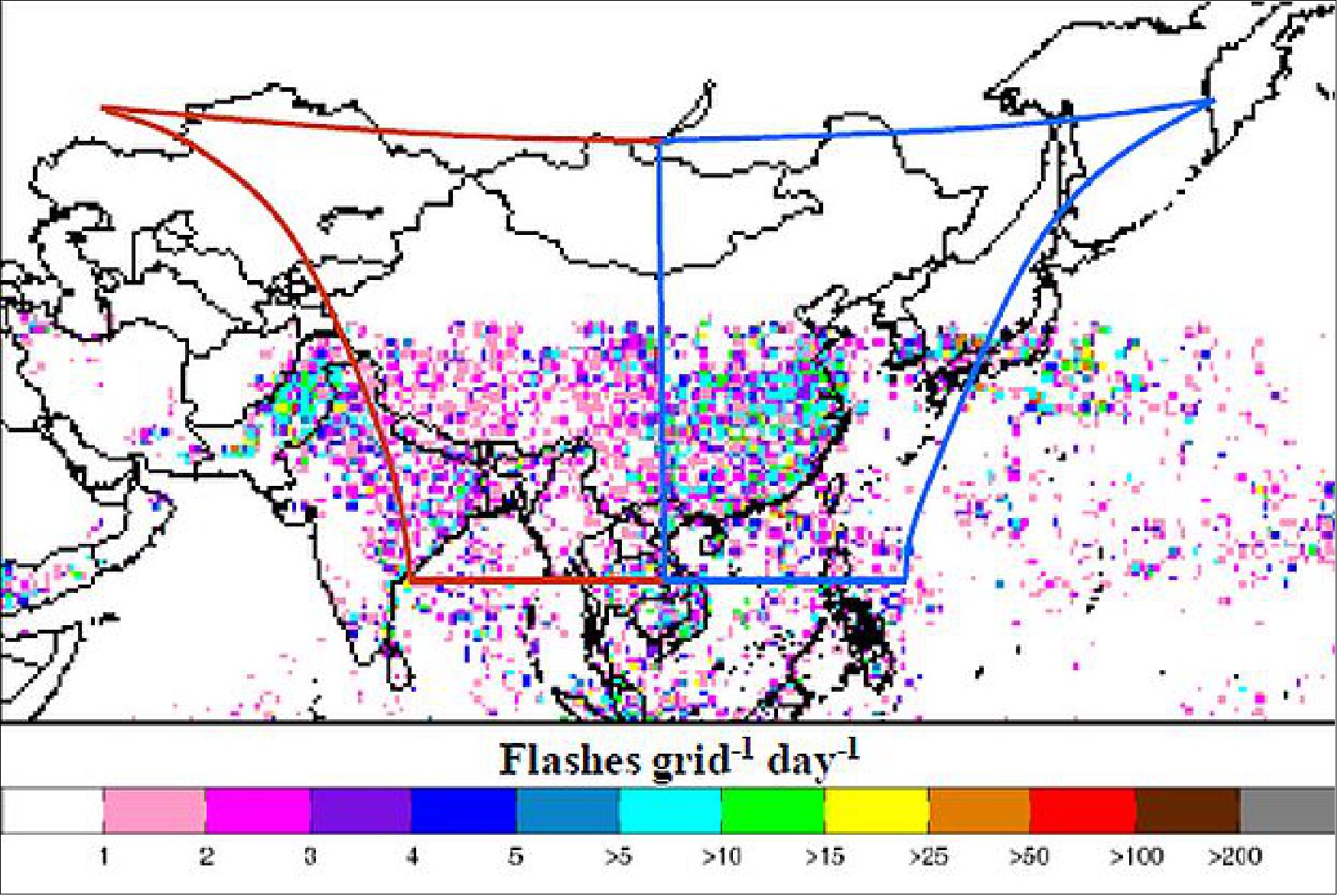
The FY-4 spacecraft will carry the GLI (Geostationary Lightning Imager), which is the first lightning detection sensor on China's satellites. The GLI will be used to observe regional lightning activity in China. The GLI products will be used in forecasting and warning of convection precipitation, and studying of Earth's electric field. 29)
The objectives of the FY-4 GLI instrument are to measure the total lightning (both intracloud and cloud-to-ground) activity within its FOV (Field of View) continuously during both day and night. It will provide measurement with a resolution of 7.8 km at the subsatellite point and full disk continuously observed with a time resolution of about 2 ms. The CCD (Charge-Coupled Device) camera will operate at 777.4 nm to count flashes and measure their intensity. For that 777.4 nm is within the solar reflective band, a vicarious calibration using DCCs (Deep Convective Clouds) as stable targets is applicable.
The GLI 400 x 600 pixel CCD focal plane will stare continuously at storms from the FY-4 satellite. The GLI shall have a continuous monitoring capability across a coverage (9,000 km diagonal field-of-view) with a near-uniform round sample 8-14 km pixel footprint resolution.
Spatial resolution | about 6.8 km at SSP (Sub-Satellite Point) |
Sensor size | 400 x 300 x 2 |
Wave-length at center, band width | 777.4 nm, 1nm±0.1nm |
Detection efficiency | >90% |
False-alarm ratio | < 10% |
Dynamic range | > 100 |
SNR (Signal to Noise Ratio) | > 6 |
Frequency of frames | 2 ms (500 frames/s) |
Data quantization | 12 bits |
Measurement error | 10% |
SEP (Space Environment Monitoring Package)
Monitoring of charged particles at platform level. Package of instruments for energetic particle detectors. Set of counters for electrons (0.4-4 MeV) and protons (1-165 MeV).
• High-energy Proton Detector: 8 channels in the energy range of 1-165 MeV; the FOV is conical at 60º.
• High-energy Electron Detector: 9 channels in the energy range of 0.4 - 4 MeV; the FOV is conical at 25º.
• Package of instruments including a FGM (Flux Gate Magnetometer), and radiation dosimeter and surface charging sensors. Dynamic range of FGM: ±0.01 to ±600 nT for each component, with resolution ±0.06 @ maximum of the dynamics.
DCS (Data Collection System)
Data collection from DCPs (Data Collection Platforms) in the ground segment. Two types of DCPs will be served: either regional, or international (i.e. migrating across the field of view of more geostationary satellites).
Ground Segment
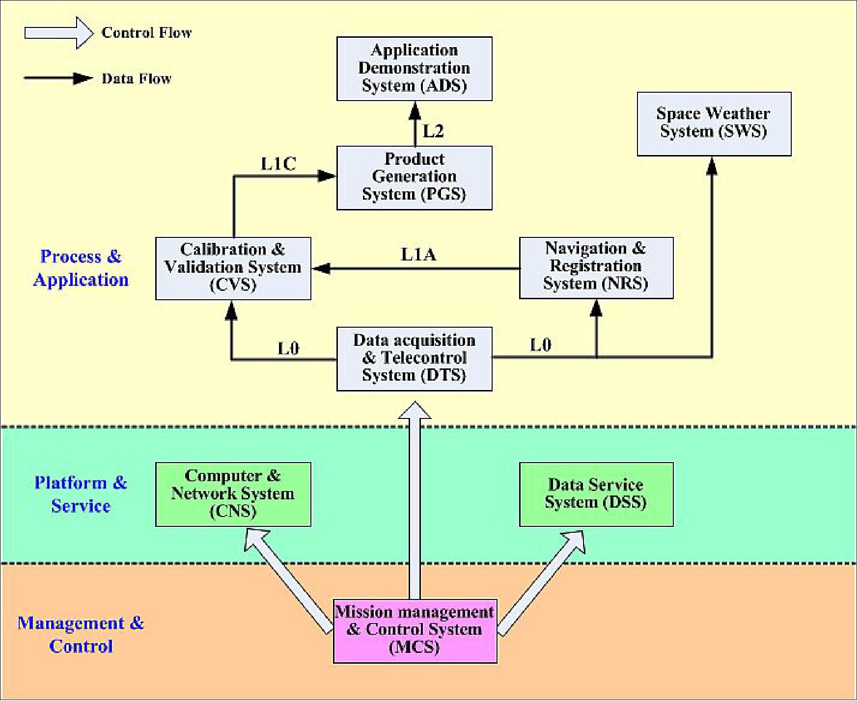
FY-4A will provide 28 baseline products as shownin Table 5. All algorithm design and development have already been completed. The next step plans to use simulation data to validate the reliability of each algorithm.
Baseline Products of imager (AGRI) & LMI | |||
No | Products | No | Products |
1 | Cloud Masks | 13 | Downward Shortwave Radiation: Surface |
2 | Cloud Type | 14 | Derived Motion Winds |
3 | Cloud Top Temperature | 15 | Lightning Detection |
4 | Cloud Top Pressure | 16 | Rainfall Rate /QPE (Quantitative Precipitation Estimation) |
5 | Cloud Optical Depth | 17 | Convective Initiation |
6 | Cloud Liquid Water | 18 | Tropopause Folding Turbulence Prediction |
7 | Cloud Particle Size Distribution | 19 | Sea Surface Temperature (skin) |
8 | Aerosol Detection | 20 | Fire/Hot Spot Characterization |
9 | Aerosol Optical Depth | 21 | Land Surface (Skin) Temperature |
10 | Downward Longwave Radiation: Surface | 22 | Land Surface Emissivity |
11 | Upward Longwave Radiation: TOA | 23 | Snow Cover |
12 | Upward Longwave Radiation: Surface |
| Space weather products |
13 | Reflected Shortwave Radiation: TOA |
|
|
Baseline Products of sounder (GIIRS) | |||
24 | Atmospheric Temperature, Humidity and Ozone Profiles (Clear) | 25 | Atmospheric Temperature and Humidity Profiles |
Baseline Products of SEP | |||
26 | Distribution of High Energy Particle Products | 27 | Intensity of Magnetic Field |
28 | Effects of Spatial Environment |
|
|
References
1) "Brief introduction of FY-4 Satellites," CMA, Sept. 16, 2015, URL: http://www.cma.gov.cn/en2014/news/Features/201509/t20150916_293082.html
2) "FY-4 Series Satellites," NSMC, URL: http://www.nsmc.cma.gov.cn
/en/NSMC/Channels/FY-4SeriesSatellites.html
3) "CMA Report on Preparations for FY-4," CGMS-39, CMA-WP-06, St. Petersburg, Russia, Oct. 3-7, 2011, URL: http://www.nsmc.cma.gov.cn/en/NSMC/UploadFiles/
files/CMA%20Report%20on%20Preparations%20for%20FY-4.pdf
4) Peng Zhang, "Future Fengyun Observing System," 19th International TOVS Study Conference, 26 March – 1 April 2014, Jeju Island, Republic of Korea, URL: https://cimss.ssec.wisc.edu
/itwg/itsc/itsc19/program/presentations/26Mar2014/session_3a/sp_5_zhang.pdf
5) http://www.nsmc.cma.gov.cn/NSMC_EN/Channels/100099.html
6) Ruixia Liu, "Status of Current and Future Satellite Programs of China Meteorological Administration," The 1st KMA International Meteorological Satellite Conference, Seoul, Korea, November 16-18, 2015, URL: http://www.kmaimsc.kr/html/menu1_sub4.php
7) "FengYun 4," Dragon in Space, April 3, 2012, URL: http://www.dragoninspace.com
/earth-observation/fengyun4.aspx
8) "FY-4 Program," CMA, URL: http://www.nsmc.cma.gov.cn/newsite/NSMC_EN/Channels/100099.html
9) Jun Yang, "China's FengYun Meteorological Satellite Programs," 17th International TOVS Study Conferences, Monterey, CA, 14 - 20 April 2010, URL: http://cimss.ssec.wisc.edu/itwg/itsc/itsc17/session8/8.7_j_li.pdf
10) Peng Zhang, "The status and future plan of Yengyun(FY) meteorological Satelltes," March 5, 2012, URL: https://gsics.nesdis.noaa.gov/pub/Development/20120305/Day1_GSICS_1015_Zhang_Fengyun_Status.pdf
11) Jun Yang, "The status and future plan of China's FengYun Meteorological Satellite Programs," 18th International (A)TOVS Study Conferences, Toulouse, France, 20 – 27 March 2012, URL: http://cimss.ssec.wisc.edu/itwg/itsc/itsc18/program/files/ITSC18_JunYang.pdf
12) Feng Lu, "CMA report on the current and future satellite systems," CGMS-42 (Coordination Group for Meteorological Satellites) plenary session, Guangzhou ,China, May 2014, URL: http://www.eumetsat.int/website/wcm/idc/idcplg?IdcService=GET_FILE&
RevisionSelectionMethod=LatestReleased&Rendition=Web&dDocName=CWPT_1242
13) Feng Lu, "Preparing a seamless transition towards FY-4," 4th Asia-Oceania Meteorological Satellite Users Conference, Melbourne, Australia, Oct. 9-11, 2013, URL: http://www.wmo-sat.info
/satellite-user-readiness/wp-content/uploads/2014/06/
s2_1350_Toward_a_seamless_transition_of_FY-4V2.pdf
14) "China launched next-generation geostationary meteorological satellite FY-4-01," Shanghai Daily, Dec. 11, 2016, URL: http://www.shanghaidaily.com/nation/
China-launched-nextgeneration-geostationary-meteorological-satellite-FY401/shdaily.shtml
15) Tomasz Nowakowski, "Long March 3B sends Fengyun-4A weather satellite into orbit," Spaceflight Insider, Dec. 10, 2016, URL http://www.spaceflightinsider.com/organizations/
china-national-space-administration/long-march-3b-sends-fengyun-4a-weather-satellite-into-orbit/
16) William Graham ,"China's Chang Zheng 3B launches Fengyun 4B weather satellite," NASA Spaceflight.com, 2 June 2021, URL: https://www.nasaspaceflight.com/2021/06/chang-zheng-3b-fengyun-4b/
17) Stephen Clark, "China launches Fengyun 4B meteorological satellite," Spaceflight Now, 6 June 2021, URL: https://spaceflightnow.com/2021/06/06/china-launches-fengyun-4b-meteorological-satellite/
18) "OSCAR," WMO, 7 July 2021,URL: https://space.oscar.wmo.int/satellites/view/fy_4b
19) National Satellite Meteorological Center (NSMC), 1 February 2019, URL: https://fy4.nsmc.org.cn/nsmc/en/theme/FY4A.html
20) "Status report on the current and future satellite systems by CMA," CGMS (Coordination Group for Meteorological Satellites), CGMS46-CMA-WP-01, Plenary session, agenda item D.1, 2 June 2018, URL: https://www.cgms-info.org/Agendas/PPT/CGMS-46-CMA-WP-01
21) "China's Fengyun-4 delivers first round of imagery and data + Shijian-13 set to go in April," Satnews Daily, Feb. 28, 2017, URL: http://www.satnews.com/story.php?number=1787654954
22) "China-Weather Satellite/Images," China Central Television (CCTV), Feb. 27, 2017, URL: http://newscontent.cctv.com/NewJsp/news.jsp?fileId=397808
23) Xiang Fang, "Preparation for FY-4A," WMO, Commission for basic systems open program area group on integrated observing systems, Expert Team on Satellite Utilization and Products, Eight Session, Geneva, Switzerland, April 14-17, 2014, URL: https://web.archive.org/web/20151016234220/http://www.wmo.int/pages/prog/sat/meetings/documents/ET-SUP-8_Doc_10-03_FY-4A.pdf
24) Tang Shihao, "Fengyun Meteorological Satellite and application service," CMA, 12-13 August 2018, URL: http://www.cma.gov.cn/en2014/20150311/20181030
/2018103005/201811/P020181102624439658399.pdf
25) Peng Zhang, Lin Zhu, Shihao Tang, Ling Gao, Lin Chen, Wei Zheng, Xiuzhen Han, Jie Chen and Jiali Shao, "General Comparison of FY-4A/AGRI With Other GEO/LEO Instruments and Its Potential and Challenges in Non-meteorological Applications," Frontiers in Earth Science, 11 January 2019, URL: https://www.frontiersin.org/articles/10.3389/feart.2018.00224/full
26) Yongfang Zhang, Jungang Miao, Haibo Zhao, Guangbin Cui, Yan Shi, "A five-frequency band quasi-optical multiplexer for geostationary orbit microwave radiometer," Proceedings of IGARSS (International Geoscience and Remote Sensing Symposium), Munich, Germany, July 22-27, 2012
27) Hao Liu, Ji Wu, Shengwei Zhang, Jingye Yan, Lijie Niu, Cheng Zhang, Weiying Sun, Huiling Li, Bin Li, "The Geostationary Interferometric Microwave Sounder (GIMS): Instrument Overview and Recent Progress," Proceedings of IGARSS (International Geoscience and Remote Sensing Symposium), Vancouver, Canada, July 24-29, 2011
28) Weiying Sun, Hao Liu, Cheng Zhang, Shengwei Zhang, Ji Wu, "Design, Position Error Analysis and Adjustment of Antenna Array for Geostationary Interferometric Microwave Sounder," Proceedings of IGARSS (IEEE International Geoscience and Remote Sensing Symposium), Melbourne, Australia, July 21-26, 2013
29) Dongjie Cao, Fuxiang Huang, Xiushu Qie, "Development and Evaluation of detection algorithm for FY-4 Geostationary Lightning Imager (GLI) measurement," XV International Conference on Atmospheric Electricity, 15-20 June 2014, Norman, Oklahoma, USA, URL: http://www.nssl.noaa.gov/users/mansell/icae2014/preprints/Cao_59.pdf
30) Caiying Wei, "Updates on Chinese Meteorological Satellite Programs," 6th Asia/Oceania Meteorological Satellite Users' Conference, Tokyo, Japan, Nov. 10, 2015, 2nd ISCC Meeting was held during Oct. 14-17, 2015, Beijing, China, URL: http://www.data.jma.go.jp/mscweb/en/aomsuc6_data/oral/s01-05.pdf
The information compiled and edited in this article was provided by Herbert J. Kramer from his documentation of: "Observation of the Earth and Its Environment: Survey of Missions and Sensors" (Springer Verlag) as well as many other sources after the publication of the 4th edition in 2002. - Comments and corrections to this article are always welcome for further updates (eoportal@symbios.space).
Spacecraft Launch Mission Status Sensor Complement Ground Segment References Back to top