Gokturk-2 Imaging Mission, Turkey
EO
Imaging multi-spectral radiometers (vis/IR)
Operational (extended)
TUBITAK
Quick facts
Overview
| Mission type | EO |
| Agency | TUBITAK |
| Mission status | Operational (extended) |
| Launch date | 18 Dec 2012 |
| Instrument type | Imaging multi-spectral radiometers (vis/IR) |
| CEOS EO Handbook | See Gokturk-2 Imaging Mission, Turkey summary |
Gokturk-2 (Göktürk-2)Imaging Mission, Turkey
Spacecraft Launch Mission Status Sensor Complement References
Gokturk-2 is a high-resolution optical reconnaissance and Earth observation mission (dual use - civil and defense) of the Turkish government's Undersecretariat for the Defense Industry (SSM). In July 2009, an agreement was signed in Ankara with the Italian space systems company Telespazio (Finemeccanica/Thales) to built the Göktürk spacecraft plus training and ground facilities. Already in December 2008, the Turkish Ministry of Defense had selected the offer of Telespazio among the various bidders for Göktürk-1. — In addition to the construction and launch of the spacecraft, the Telespazio-led team has agreed to provide Turkey with one fixed and one mobile ground station to receive imagery of the Göktürk spacecraft.
The project goal is to procure a satellite system in line with technological cooperation and joint development and usage principles to meet the need for high-resolution imagery for military intelligence on a global scale.
The Göktürk satellite will also be used for monitoring civilian activities such as control of forestland, tracking illegal construction, rapid assessment of damage after natural disasters, determination of agricultural boundaries and geographical data gathering. The project also aims to furnish national industries with the capability of designing and integrating satellite systems and running tests on them here in Turkey. Turkish defense industry companies and research centers such as TAI (Turkish Aerospace Industries, Inc.), Aselsan, the Technological and Scientific Research Council of Turkey (TÜBİTAK), and TurkSat A.S. will participate in all phases of the project. The contribution of local companies in Turkey to the project will be around 22%, and the imagery obtained from the system will be sold on the international market.
The goal of the government of Turkey is to infuse their home industry with the capability of developing their own future spacecraft. 1) 2) 3) 4)
Telespazio (Rome, Italy) and its sister company TAS (Thales Alenia Space) will be the prime developers of the Gokturk-1 spacecraft. The satellite will use the Proteus multimission platform. The Italian-French contractor will also deliver a satellite assembly integration and test facility to be built at Turkey's TAI A.S. company with assistance from Turksat, Turkey's national telecommunications operator. TAI A.S. is designated as the main local partner with the purpose of building Gokturk-1 in its national satellite assembly, integration and test center at Ankara.
Spacecraft
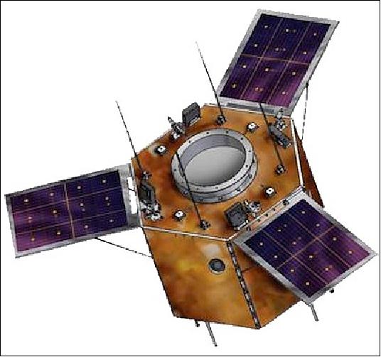
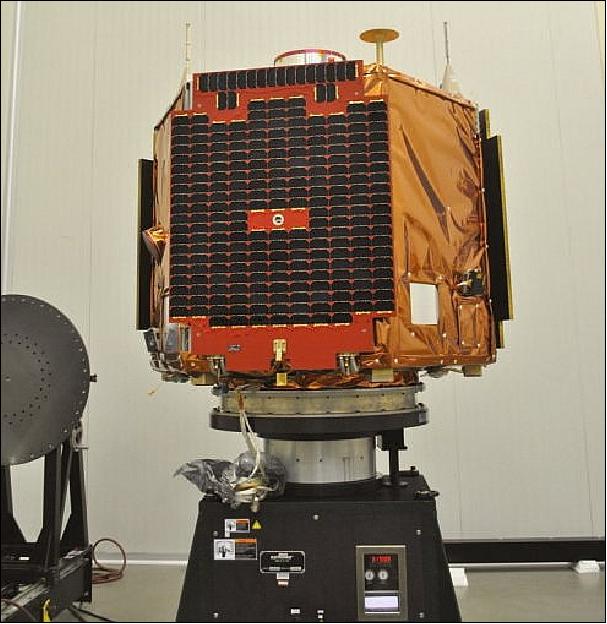
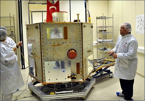
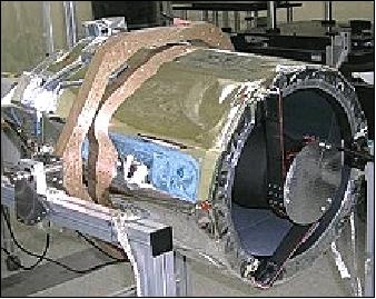
Gokturk-2 is a minisatellite built by the TUBITAK-UZAY and TAI (Turkish Aerospace Industries Inc.) consortium. The indigenously designed Gokturk-2 spacecraft was integrated and tested (bus assembly & integration, payload integration, mass properties measurement, system level functional & thermal vacuum tests) at TAI's facilities.
EPS (Electrical Power Subsystem): The design of the EPS reflects the need for autonomous operation independent of all other systems and no intervention from the ground station. To meet the system-level requirements and to achieve its purpose, Gokturk-2 power subsystem consists of main components as follows: 5)
• Solar Panels (SPs)
• Battery Charge Regulators (BCRs)
• Battery Block (BB)
• Power Conditioning & Distribution Module (PCDM)
• Electronic Separation Switch Module (ESSM)
• Pyro Driver Module (PDM).
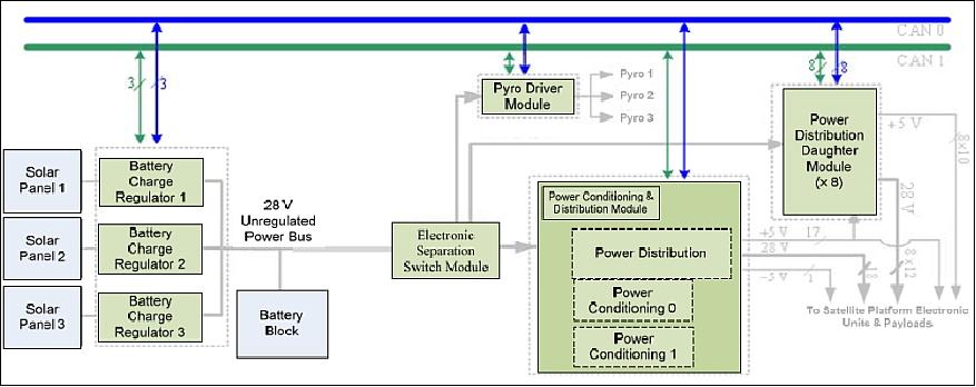
The block diagram of the EPS is shown in Figure 2. It features three deployable, but fixed, solar arrays that are installed on three sides of the hexagonal satellite body. 6)
The solar panels are provided by STI (SpaceTech GmbH Immenstaad), Germany, consisting of: 7)
- 3 solar panels including the photovoltaic assembly
- the solar panel deployment mechanisms
- the PDM (Pyro Drive Module) electronics executing the deployment sequence of the mechanism.
Each of the three panels on the spacecraft consists of four arrays with 3 strings of 20 cells each. In addition to the cells temperature sensors for thermal control, thermistors as input to the satellite's maximum power point tracker as well as bleed resistors for controlled insulation with the spacecraft body are accommodated on each panel. Third generation Azur GaAs triple junction cells with a rated efficiency of 28 % are used to make up the photovoltaic assembly. Each cell is protected with a bypass diode and each solar string by a blocking diode (Ref. 5).
The power produced by solar panels is utilized to charge the BCRs. Each BCR module consists of four independent working battery charge regulators connected to four independent solar cell sections on each solar panel separately, where each independent solar cell section on each panel operating In MPPT (Maximum Power Point Tracking) mode or battery end of charge (EoC) mode on each BCR module. This makes twelve solar cell sections in total on three solar panels and twelve regulators in total on three BCR modules. A nominal capacity of 34.8 Ah Li-ion battery block constitutes the unregulated bus for Gokturk-2 EPS.
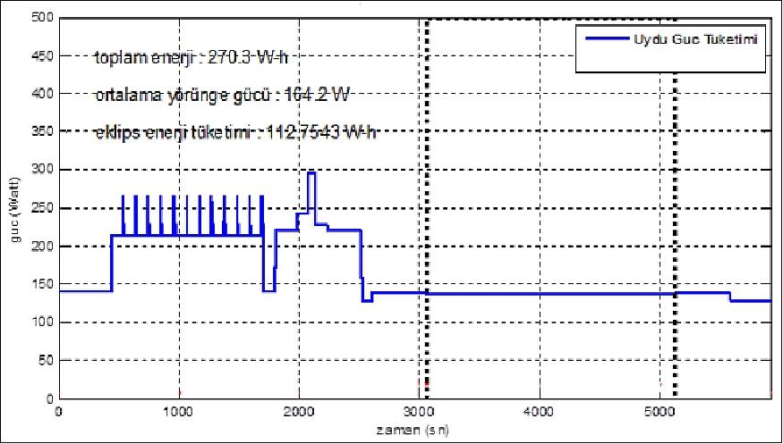
The unregulated bus voltage at 28±5 V is distributed to the power conditioning module and power distribution modules via ESSM (Electronic Separation Switch Module). The PCDM also converts the raw 28±5 V battery voltage level to regulated ±5 V level, which is necessary for some subsystems, payloads, and power system internal usage. The power condition part of PCDM is realized as cold redundant for high system level reliability. The PCDM and PDDMs have also an under voltage detection and reset circuitry for battery discharge protection. Each power system module has CAN (Controller Area Network) microcontrollers to provide a serial interface for telemetry and telecommands via flight computer and ground station. The on-orbit average power consumption is 164.2 W as illustrated in Figure 3.
RF communications: S-band for TT&C data. X-band for the payload data downlink at > 100 Mbit/s. The on-board image storage capacity is 8 GB + 32 GB of science data.
The spacecraft has a launch mass of ~ 450 kg (dry mass of 408 kg), the design life is 5 years (with a goal of 7 years).
Gokturk-2 is Turkey's second Earth observation satellite, following the RASAT EO microsatellite, launched on August 17, 2011 aboard a Dnepr vehicle from the Yasny/Dombarovsky launch site located in the Orenburg Region, Russia.
Launch
The Gokturk-2 spacecraft was launched on Dec. 18, 2012 (16:12:52 UTC) on a Long March-2D (CZ-2D) vehicle from the Jiuquan Satellite Launch Center in China. 8) 9) 10) 11)
Orbit: Sun-synchronous orbit, mean altitude of 684 km, inclination = 98.1º, period = 98.3 minutes, LTAN (Local Time on Ascending Node) = 10.30 hours.
Note: The Gokturk-1 spacecraft is still under development. A launch of of the Gokturk-1 mission is planned for late 2016.
Mission Status
• October 2019: The Göktürk-2 satellite completed more than 35,000 orbits since it was launched in December 2012. The mission is still fully operational in 2019. 12)
- The Göktürk-2 project is one of the best success stories of Turkey regarding its space activities. It has maintained the space infrastructure of Turkey. With the implementation of the project, many concrete space-related advances have been made on the basis of the National Space Research Program and cooperation among Turkish institutions and enterprises had been developed. Turkey has made continual progress in space activities with Göktürk-2, both human, scientifically, technological, organizational, industrially and with its institutions. An important increase in space activities in Turkey (public, university and industry focused) has been observed.
- With Göktürk-2, Turkey has gained a space operational capability and a robust infrastructure. This project has enabled to create a new space industry in Turkey. The foundations of the national space industry were laid with the project and the experience gained by Turkish scientists, engineers, managers and all that will constitute the workforce capacity of the new generation national space/satellite projects.
- Turkey's investment in space has provided a significant jump in the threshold of a new era in space technology developments. It has come to a position producing its own spacecraft systems. The project has provided an international prestige and visibility in the space arena between the space faring countries. And Turkey has become a country, capable of designing, manufacturing, and operating a mission without a space agency.
- The project is paving the way for the establishment of a space agency in Turkey.
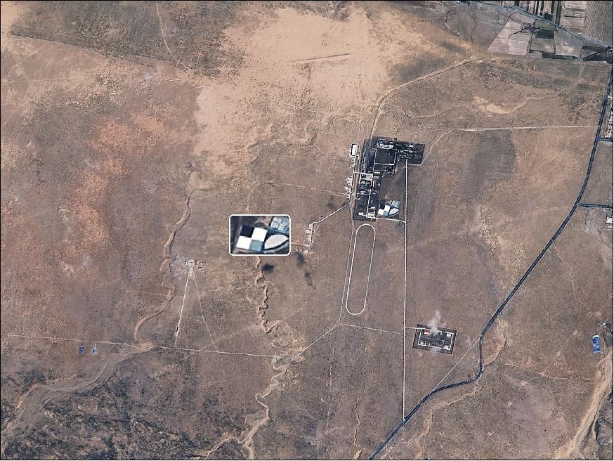
• January 2017: MTF (Modulation Transfer Function) targets in China and France have been taken to be used for geometric calibration studies of the Göktürk-2 sensor complement. Similarities to the checker board are used for MTF measurements of satellite images. It is possible to analyze the image quality with the fan and other geometric shapes used. — The calibration site in Bautou, China, consists of 4 painted concrete and other geometric shapes, each measuring 48 m x 48 m (Figure 6). 13) 14)
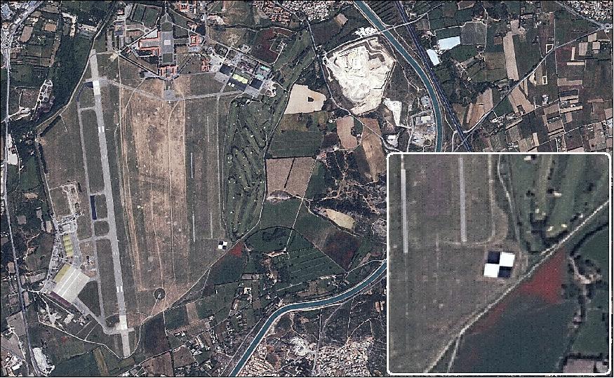
- The MTF target in Salon de Provence, France, is located within the military airfield. Each is a black and white checkerboard board consisting of 4 cages with a dimension of 30 m x 30 m (Figure 7).
• April 2016: The Gokturk-2 satellite and its payload are operating nominally in 2016 — in its 4th year of operations. 15)
Legend to Figure 8: According to Turkish media, the bridge should be opened for traffic in the summer of 2016. The construction of the Istanbul's Yavuz Sultan Selim Bridge (YSS), which began in May 29, 2013, now unites the Asian and European sides of the Bosporus. It is the third bridge across the Bosporus. The total length of the bridge is 2,164 m. The bridge, which stretches 1,408 m over the Bosporus, has eight lanes of highway and two lanes of railway. It will be the longest suspension bridge in the world that includes a rail system. The height of the tower in the village of Garipçe on the European side is 322 m and the tower in the Poyrazköy district on the Asian side is 318 m high. The bridge will have the highest abutments in the world. — The rail system crossing the bridge will run from Edirne to Izmit, will be integrated into the Marmaray and Istanbul Metro and will also connect Istanbul Atatürk International Airport, Sabiha Gökçen International Airport and the third airport, also currently under construction. 17)
• July 13,2015: The Gokturk-2 satellite and its payload are operating nominally in 2015. So far, the spacecraft has acquired > 10,000 images on a global scale. 18)
• On Dec. 18, 2014, the Gokturk-2 spacecraft was two years on orbit. The spacecraft recorded more than 10,000 passes, with nearly 5000 images and covered 9,850,000 km2 ground surface. Gokturk-2 continues to serve at its 684 km altitude under the control of the Turkish Air Force. 19)
• On Nov. 1, 2014, Gokturk-2 completed its 10,000th orbit. Connection with Gokturk-2 has been established around 4000 times via satellite earth station deployed at Reconnaissance Satellite Battalion in Ahlatlıbel-Ankara and over 4800 reconnaissance missions has been succeeded within two years. Reconnaissance demands of the Turkish Armed Forces and public institutions have been met covering 9,850,000 km2 from various parts of the world, including 1,650,000 km2 in Turkey. 20)
• January 22, 2014: According to TAI, Turkey's first medium-resolution optical Earth observation satellite, the domestically built Gokturk-2, has completed a year in orbit with successful operations that have no geographical restrictions on image gathering for military and civil applications. As of January 13, 2014, Gokturk-2 had completed 5344 orbits. 21)
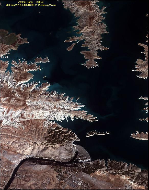
Legend to Figure 10: The Ataturk Dam is located on the Euphrates River in southeastern Turkey. The construction of the earth and rock-fill dam with a central core was started in 1983 and completed in 1990. The dam, one of the world's largest, has an embankment of 184 m in height and 1,820 m in length. The reservoir created behind the dam, called Lake Atatürk Dam (Turkish: Atatürk Baraj Gölü), is the third largest in Turkey, built to supply water for irrigation and power generation. The reservoir has a size of 817 km2 and can hold a volume of 48.7 km3 of water.
• The Gokturk-2 satellite and its payload are operating nominally in 2013. 22)
• In January 2013, Nihat Ergün, Minister of Science, Industry and Technology of Turkey, announced that the project began receiving initial imagery from the satellite ten days ago. According to Ergün, the Air Forces Command will primarily benefit from the imagery obtained by the observation satellite and will have the capabilities of acquiring and processing the imagery on their own land station. 24)
• On December 26, 2012, the GökTürk-2 project team is reporting that it received the temperature, current, regression data and camera images from the spacecraft for the past four days. 25)
• The first signal from Gokturk-2 was received at 17:39 UTC on Dec. 18, 2012 in the Tromsø Satellite Station, northern Norway.
Sensor Complement
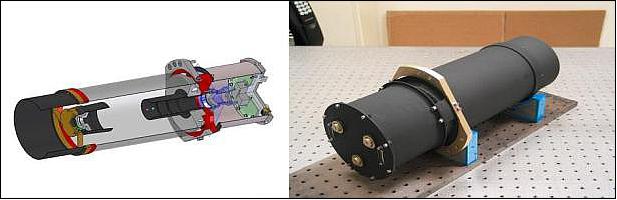
EOS-C (Earth Observation Satellite - Camera)
EOS-C is a multispectral pushbroom imager. The data requirements call for civil and defense applications: disaster and emergency response, environment, mapping, urban planning, landcover, geology, coastal zone monitoring, ecosystem, and water resource management.
The EOS-C instrument was built by SI (Satrec Initiative) of Daejeon, Korea for TUBITAK/UZAY. The instrument is based on the EOS-C version 3.0 (of DubaiSat-1 heritage).
Instrument type | Pushbroom imager |
Spectral bands | Pan: 450-900 nm |
Spatial resolution | Pan = 2.5 m, MS = 10 m, SWIR = 20 m |
Swath width | 20 km x 640 km (one pass) |
Data quantization | 8 bit (dynamic), 11 bit (total) |
Optics | Telescope aperture diameter of 492 mm, length of 985 mm |
Instrument mass | < 41 kg (optics < 35 kg, electronics < 6 kg) |
Instrument power | < 69 W (peak power with all heaters on) |
The satellite can download images at a rate of 100 Mbit/s, and capture wide area and stereo images of 100 km x 34 km and 100 km x 20 km dimensions, respectively. The geo-location and the pointing accuracies of the satellite are less than 1km. The satellite can store up to 45 frames measuring 20 km x 20 km each. 26)
Kuzgun
Kuzgun is an experimental infrared camera with a spectral range of 0.8-1.7 µm and a resolution of 20 m. The original design and production of this camera system were made by TÜBİTAK UZAY Institute in Turkey. This camera is able to synchronize with the main camera (Ref. 12).
Sensor type | Shortwave infrared |
Spectral range | 800-1700 nm |
Spectral resolution | 20 m SWIR , 4 m Pan |
Optoelectronic System | MTF ~ 40%, 20 lp / mm |
Focus distance | 850 mm |
Illumination | Adjustable illumination duration and sampling period for different orbits |
Adjustment | Automatic adjustment of lighting time according to lighting amount |
Local memory | 128 MB |
Radiometric resolution | 8 bit digitization |
Data transmission | 25MHz LVDS, 100 MHz SpaceWire, Real-time LVDS |
Swath width | 15 km |
Ground Segment
The Göktürk-2 ground segment is composed of the Flight and the Payload Data Operations. The Flight Operation Segment (FOS) is responsible for command and control of the satellite and is operated from The Turkish Air Force (TURAF) Space Operations Center which located in Ankara, Turkey (Figure 15).
The FOS consists of the Ground Station and Communications Network, Flight Operations Control Center and a General Purpose Communication Network. The FOS provides the capability to monitor and control the satellite during all mission Phases.
The main functions of the FOS include:
• Mission planning
• Spacecraft status monitoring
• Spacecraft control
• Orbit determination and control
• Attitude determination and control
• On-board software maintenance
• Communications.
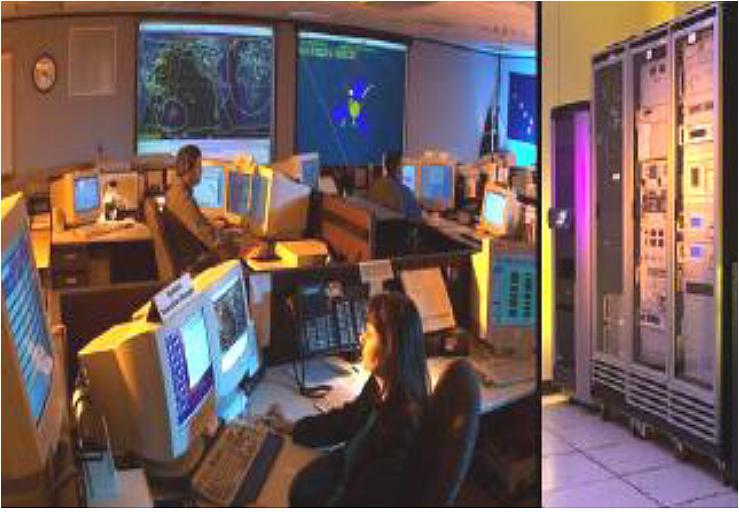
The TURAF data processing and utilization section is responsible for planning, data acquisition, processing and distribution of the Göktürk-2 satellite data. Image data processing levels and their explanatory information are given below:
• Level-0 (L0) Raw image (image with compression and cryptographic analysis)
• Level-1 (L1) Radiometric corrected image (image without detector and atmospheric defects removed, shadow, noise and blur removed, no projection information in the projection system)
• Level-2 (L2) Geometric corrected image (the effects of world curvature and state angle are eliminated, image generated using the imaging geometry model without ground control points)
• Level-3 (L3) Geo-calibrated and orthorectified image using Ground Control Points
• Level-4 (L4) Digital Elevation Model ( DEM)
• Level-5 (L5) Mosaic image
• Level-6 (L6) Thematic map (classification)
Calibration and Validation: The Göktürk-2 Calibration and Validation (Cal/Val) phase has been applied to the process of updating and validating onboard and on-ground configuration parameters and algorithms to ensure that the data product quality requirements are met.
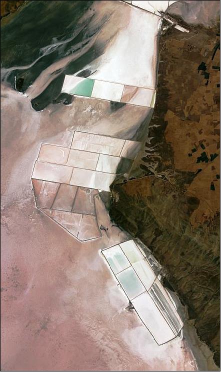
Radiometric Calibration: The radiometric calibration parameters are determined based on image acquisitions over specific areas such as instrumented Cal/Val sites from the CEOS network Tuz Gölü (Salt Lake) in Turkey (Figure 16) for cross-calibration with Landsat-8 sensors and for monitoring temporal stability.
Geometric Calibration: The validation of the geometric performance has been performed during commissioning and subsequently on a yearly basis, and include: — geolocation accuracy assessment using reference sites with geometric patterns and for which the geometry is mastered; — multi temporal registration assessment using image correlation techniques; and — multispectral registration assessment using correlations between images of different bands.
Applications and Contributions
The mission has been designed to fulfil user requirements.27) Observations from Göktürk-2 mission have been used and continue to be use d by military and public research organizations. Applications for emergency response and for the management of operations, situation awareness and intelligence for regional crises has contributed to understand where crises occur (especially in the Middle East region).
Göktürk-2 made also a significant contribution to land monitoring by providing both urban land use and land-cover maps, to monitoring of forest areas, discrimination and classification of agricultural areas, vegetation cover maps and crop identification, fire risk areas mapping, flood monitoring, land-cover change and snow cover maps based on frequent and systematic coverage. 28)
In addition, the imagery is used for disaster management by providing recent synoptic views of an area affected by a disaster before it occurred and updated synoptic views to support disaster relief activities (e.g. surveillance, critical infrastructure).
References
1) "Turkey gives go-ahead to Göktürk satellite project," July 18, 2009, URL: http://www.todayszaman.com/tz-web/news-181288-turkey-
gives-go-ahead-to-gokturk-satellite-project.html
2) Tamer Özalp, "The Status of Turkish National Earth Observation Missions." GSCB (Ground Segment Coordination Body) Workshop, June 6-7, 2009, ESA/ESRIN, Frascati, Italy, URL: http://earth.esa.int/gscb/papers/2012/30-Turkish_EO_missions_status.pdf
3) Peter B. De Selding, "Turkey Expecting Satellite Deal To Spark Homegrown Space Industry," Space News July 27, 2009, p 1 and 4.
4) "Gokturk-2 Earth Observation Satellite, Turkey," URL: http://www.airforce-technology.com/projects/gktrk-2-earth-observation-satellite/
5) Hasan Özkaya, Emrah Akkuş, F. Ercan Karagöz, Başak Gonca Özdemir, "Power Subsystem of Gokturk-2 Flight Model," Proceedings of the 6th International Conference on Recent Advances in Space Technologies (RAST), Istanbul, Turkey, June 12-14, 2013
6) "High Resolution Earth Observation Satellite," TAI, URL: https://www.tai.com.tr/en/project/gokturk-2
7) "GökTürk-2 Solar Panels," URL: http://www.spacetech-i.com/GK-2_SG.html
8) "China closes 2012 with 19th successful Orbital Launch," Spaceflight 101, Dec. 18, 2012, URL: http://www.spaceflight101.com/long-march-2d-gokturk-2.html
9) Stephen Clark, "Turkish imaging satellite lifted to orbit by China," Spaceflight Now, Dec. 18, 2012, URL: http://www.spaceflightnow.com/news/n1212/18longmarch/#.UNGZJ5GQk9Y
10) "Second Turkish EO Satellite Launch Successful," Earth Imaging Express, Dec. 27, 2012, Vol. 2, No 40, URL: http://eijournal.com/industry-insights-trends/second-turkish
-eo-satellite-launch-successful?utm_source=EIX+Subscribers&utm_
campaign=436bea6fc9-Group_312_27_2012&utm_medium=email
11) "Gokturk-2 is in Space," TUBITAK-UZAY, URL: http://www.uzay.tubitak.gov.tr/tubitakUzay/en/newsArchive/gk-2.php
12) Tamer Özalp, "An Inspiring Earth Observation Mission of Turkey, GÖKTÜRK-2; New Opportunity for Space Application Community," Proceedings of the 70th IAC (International Astronautical Congress), Washington DC, USA, 21-25 October 2019, paper: IAC-19-B4.1.14, URL: https://iafastro.directory/iac/proceedings/IAC-19/IAC
-19/B4/1/manuscripts/IAC-19,B4,1,14,x51790.pdf
13) "Göktürk-2 image analysis patterns," 06 January 2017", URL: http://blog.gezgin.gov.tr/?p=1898
14) Information provided by Aziz Koru, Senior Researcher Business Development Group, TUBITAK-UZAY, Ankara, Turkey
15) Information provided by Aziz Koru of TUBITAK/UZAY, Ankara, Turkey
16) http://blog.gezgin.gov.tr/?p=1387
17) "Third Bosporus Bridge unites Europe and Asia," Sabah Daily News, March 8, 2016, URL: http://ftnnews.com/news-from-turkey/29730-
third-bosphorus-bridge-unites-europe-and-asia.html
18) Information provided by Tamer Özalp of TUBITAK-UZAY, Ankara, Turkey.
19) The First Indigenous Satellite Build Is Planned By Turkey—TÜRKSAT 6A—Plus, Gokturk-2 Celebrates Second Anniversary... On Orbit," SatNews, Dec. 19, 2014, URL: http://www.satnews.com/story.php?number=1366391123
20) "Gokturk-2 completed its 10.000th tour in the orbit," Turkish Air Force, Nov. 13, 2014, URL: http://www.hvkk.tsk.tr/en/HaberDetay.aspx?IcerikID=5720&ID=93
21) Peter B. de Selding, "Turkey's Gokturk-2 Collecting Imagery with No Restrictions," Space News, Jan. 22, 2014, URL: http://www.spacenews.com/article/military-space/39212turkey%E2%80%99s
-gokturk-2-collecting-imagery-with-no-restrictions
22) Enes Koytak, "Recent Space Activities in Turkey," 56th Session of UNCOPUOS (UN Committee on the Peaceful Uses of Outer Space), Vienna, Austria, June 12-21, 2013, URL: http://www.oosa.unvienna.org/pdf/pres/copuos2013/tech-10.pdf
23) http://blog.gezgin.gov.tr/?p=1368
24) "Turkey receives initial Gokturk-2 satellite images," Sabah, Jan. 9, 2013, URL: http://english.sabah.com.tr/economy/2013/01/09/turkey-
receives-initial-gokturk-2-satellite-images-631569259770
25) "First images received from Gokturk-2 satellite," TurkishPress.com, Dec. 26, 2012, URL: http://www.turkishpress.com/news.asp?id=383031#.UN_ncoapKTw
26) "Gokturk-2 Earth Observation Satellite, Turkey," AirForce, URL: http://www.airforce-technology.com/projects/-gktrk-2-earth-observation-satellite/
27) Göksel Gürgenburan, Emrah Çinar, "Göktürk-2: Two years of operation," 7th International Conference on Recent Advances in Space Technologies (RAST), IEEE, Conference location: Istanbul, Turkey, 16-19 June 2015
28) Ilker Gürcan, Mustafa Teke, Uğur Murat Leloğlu, "Land use/land cover classification for Göktürk-2 satellite," 24th Signal Processing and Communication Application Conference (SIU), IEEE Xplore, 23 June 2016, URL: https://web.archive.org/web/20220809121821/https://ieeexplore.ieee.org/document/7496185
The information compiled and edited in this article was provided by Herbert J. Kramer from his documentation of: "Observation of the Earth and Its Environment: Survey of Missions and Sensors" (Springer Verlag) as well as many other sources after the publication of the 4th edition in 2002. - Comments and corrections to this article are always welcome for further updates (eoportal@symbios.space).
Spacecraft Launch Mission Status Sensor Complement References Back to top