NRO (National Reconnaissance Office) Spaceborne Radar Data
EO
Cloud profile and rain radars
Atmosphere
Ocean
Quick facts
Overview
| Mission type | EO |
| Agency | NRO |
| Mission status | - |
| Launch date | 07 Oct 2021 |
| Measurement domain | Atmosphere, Ocean, Land, Gravity and Magnetic Fields, Snow & Ice |
| Measurement category | Multi-purpose imagery (ocean), Radiation budget, Multi-purpose imagery (land), Surface temperature (land), Vegetation, Gravity, Magnetic and Geodynamic measurements, Surface temperature (ocean), Landscape topography, Ocean topography/currents, Atmospheric Winds, Ice sheet topography, Lightning Detection |
| Measurement detailed | Cloud cover, Cloud imagery, Fire fractional cover, Vegetation Cover, Land cover, Atmospheric temperature (column/profile), Sea-ice cover, Atmospheric stability index, Volcanic ash, Iceberg fractional cover, Sea level, Glacier cover, Glacier topography, Auroral Emissions, Gravity field, Air temperature (near surface), Active Fire Detection, Total lightning density, Visibility, Wind stress, Turbulence |
| Instrument type | Cloud profile and rain radars, High resolution optical imagers, Earth radiation budget radiometers, Space environment, Magnetic field, Other, Atmospheric chemistry, Communications, Precision orbit, Data collection, Radar altimeters, Imaging microwave radars, Gravity instruments, Lightning sensors |
| CEOS EO Handbook | See NRO (National Reconnaissance Office) Spaceborne Radar Data summary |
NRO (National Reconnaissance Office) Spaceborne Radar Data to Tap Commercial Industry
The director of the U.S. National Reconnaissance Office (NRO) Christopher Scolese announced 7 October 2021 the agency will start buying space radar imagery from commercial providers. 1)
“Our focus today is on innovation and commercial capabilities,” Scolese said in a keynote speech at the 2021 GEOINT Symposium (5-8 October 2021, St. Louis, MO).

“I’m proud to announce the NRO’s new Broad Agency Announcement,” said Scolese.
This BAA (Broad Agency Announcement) as a “flexible approach to an acquisition process that will allow us to evaluate, leverage, and even integrate new and emerging phenomenologies like radar, hyperspectral, and radio-frequency sensing as they become available.”
The first procurement under this BAA will be for commercial synthetic aperture radar (SAR) data. Scolese said this BAA will be released in about a month.
The NRO buys traditional electro-optical imagery from commercial providers and will award new contracts early next year, said Scolese. He noted that the next step will be to work with providers of other types of commercial remote sensing phenomenologies.
The BAA for commercial radar will be open to the entire industry, including foreign-owned U.S. companies. “If you have technologies that fit the bill, come talk to us,” he said.
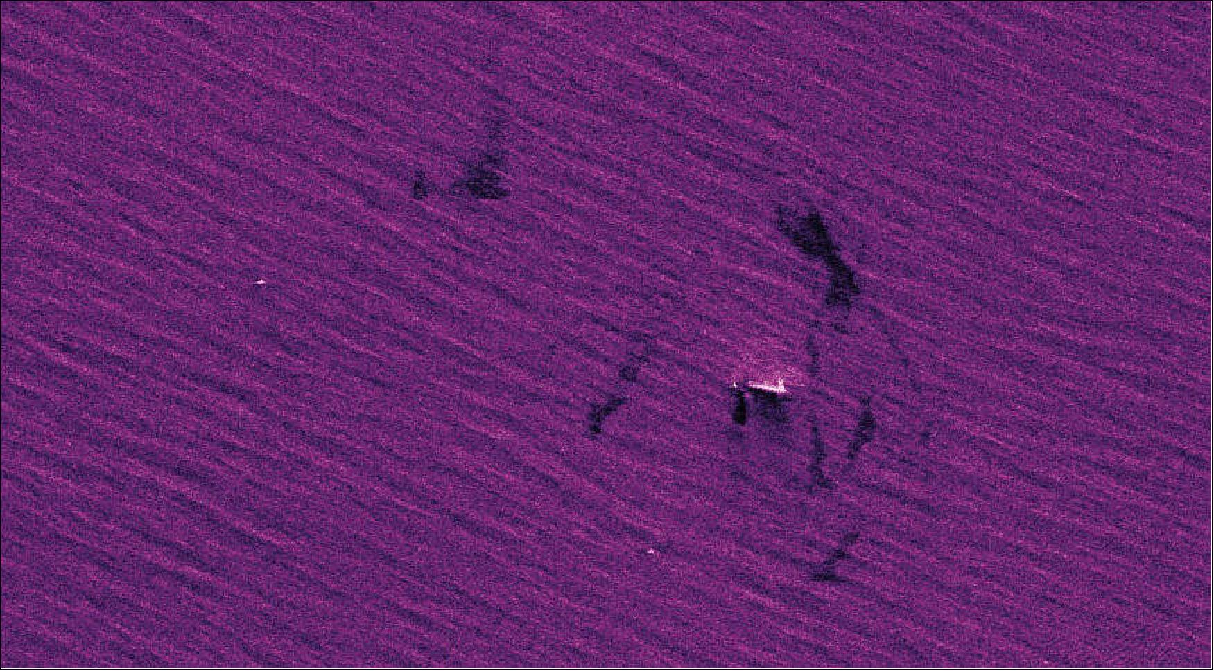
SAR imagery is in high demand in the energy and agriculture sectors and increasingly is being used by defense and intelligence agencies. Radar sees through clouds and other atmospheric obstacles that interfere with optical satellites.
The NRO in December 2019 awarded SAR imagery provider Capella Space a contract to experiment with the use of the company’s data and figure out the utility of the data for national security. The agency in November 2020 issued a request for information to get a better understanding of the state of the U.S. commercial radar imagery industry.
The NRO acquires satellite data for the U.S. intelligence community, the military and homeland security agencies.
“We’ve seen an explosion of innovation on the commercial side,” said Scolese.
“This BAA framework will allow the NRO to rapidly explore, assess, and leverage innovative industry capabilities to meet new intelligence challenges and inform operational requirements.”
Pete Muend, director of the NRO Commercial Systems Program Office, told reporters at the GEOINT Symposium that the BAA will help the agency “to onboard new entrants, across all of the phenomenologies.”
The NRO wants to work with companies that have operational constellations but also emerging ones that are now building their systems. Muend said the BAA gives the NRO options to “provide some direct support, some direct funding for providers to do some additional things for us that may not follow the purely commercial side, to satisfy some of the unique needs that we have.”
Muend said the BAA, called “Framework for Strategic Commercial Enhancements,” will be issued for different focus areas multiple times per year.
Background of the NRO and its Start of Buying Commercial Imagery
NRO (National Reconnaissance Office) is a member of the United States Intelligence Community and an agency of the United States Department of Defense (DOD) which designs, builds, launches, and operates the reconnaissance satellites of the U.S. federal government, and provides satellite intelligence to several government agencies, particularly signals intelligence (SIGINT) to the NSA, imagery intelligence (IMINT) to the NGA (National Geospatial-Intelligence Agency), and measurement and signature intelligence (MASINT) to the DIA.
NRO is considered, along with the Central Intelligence Agency (CIA), National Security Agency (NSA), Defense Intelligence Agency (DIA), and National Geospatial-Intelligence Agency (NGA), to be one of the "big five" U.S. intelligence agencies. The NRO is headquartered in Chantilly, Virginia, 2 miles (3.2 km) south of the Washington Dulles International Airport.
NRO develops, builds, launches, and operates space reconnaissance systems and conducts intelligence-related activities for U.S. national security. The NRO also coordinates collection and analysis of information from airplane and satellite reconnaissance by the military services and the Central Intelligence Agency.
The NRO was established on August 25, 1960, after management problems and insufficient progress with the USAF satellite reconnaissance program. The formation ws based on a recommendation to President Dwight D. Eisenhower during a special National Security Council meeting, and the agency was to coordinate the USAF and CIA's (and later the navy and NSA's) reconnaissance activities. The NRO's first photo reconnaissance satellite program was the Corona program. The Corona system used (sometimes multiple) film capsules dropped by satellites, which were recovered mid-air by military craft. The first photos of the Corona program were declassified in February 1995.
During the Cold War, the U.S. relied on photo reconnaissance satellites to track adversaries' weapons development, especially in the Soviet Union and China. From the early 1960s to mid-1980s, photography from space was often the only way to get critical data about nuclear threats. The NRO also managed follow-on efforts called ARGON, LANYARD, GAMBIT and HEXAGON. All these used photographic film and re-entry vehicles to return the exposed film to earth. Later satellites, including those used today, transmit data electronically from space. The NRO continues to manage reconnaissance programs, contributing greatly to national security. The last HEXAGON flight was in 1986.
Reconnaissance satellites have played a critical role in maintaining U.S. national security since 1960. They dispelled U.S. fears of a "missile gap," proving the U.S. had not fallen behind the USSR in weapons progress in the 1950s and 1960s. Accurate information from satellites allowed defense officials to act on facts, not speculation. — Over the years, satellites captured images of every new and existing Soviet strategic missile silo. This helped the U.S. confidently verify arms control agreements and track conflicts. The CIA described the value of such knowledge as "virtually immeasurable."
In the 21st century, the NRO is the U.S. intelligence agency responsible for developing, launching and operating the nation’s spy satellites. It is also the primary acquirer of commercial imagery for the federal government. 3)
In June 2021, NRO issued a draft solicitation for the EOCL (Electro-Optical Commercial Layer) program procurement. A final request for proposals is being reviewed by the Defense Department and the U.S. intelligence community, and should be released before the end of the year, an NRO spokesman told SpaceNews.
Under this new imagery procurement, the NRO plans to buy products from multiple vendors and move beyond the current single-supplier arrangement that the National Geospatial Intelligence Agency signed more than a decade ago with DigitalGlobe, which is now Maxar Technologies. The NGA in 2017 turned over responsibilities for commercial imagery procurement to the NRO, while the NGA remains the primary buyer of commercial geospatial data analytics.
The NRO is expected to select at least three U.S. suppliers and structure the program with onramps for new providers. The agency also will require vendors to sign “end user license agreements” so imagery can be shared across government agencies without additional licensing fees.
“We reconfigured our next-generation commercial contracts to include pricing that incentivizes innovation and rewards the development of new capabilities,” NRO Director Christopher Scolese said Aug. 24 at the the 36th Space Symposium in Colorado.
The EOCL program is focused primarily on acquiring imagery for military users but will also obtain imagery to help domestic agencies monitor natural disasters, crop production and climate change. “Today’s commercial partners now provide imagery as a service, which allows us to focus on the difficult tasks,” said Scolese.
EOCL to replace EnhancedView
Maxar Technologies is the NRO’s sole supplier of commercial high-resolution satellite imagery under the EnhancedView contract, a deal that dates back to 2010 when NGA selected two imagery providers — DigitalGlobe and GeoEye. By 2012, government spending cuts forced NGA to slash its imagery budget by half. EnhancedView subsequently was reduced from more than $7 billion to about $3.5 billion, which led to the merger of the two companies under DigitalGlobe.
The NRO pays Maxar $300 million a year for access to the former Digital Globe’s WorldView-1, WorldView-2, WorldView-3 and GeoEye-1 satellites, as well as the company’s image archive. EnhancedView was a 10-year deal set to expire in 2020 but when the NRO took over the management of the contract, it added three one-year options worth about $300 million each. The agency so far has exercised two one-year options, extending the contract through August 2022.
A loud and clear sign that the NRO wanted to shift to a multi-vendor agreement was the 2019 award of three study contracts. One was to incumbent Maxar and the other two to smallsat constellation operators Planet and BlackSky. The contracts gave the NRO access to the companies’ business plans and finances as well as the projected capacity of their satellite constellations.
Maxar to Face Competition
Maxar’s competitors Planet and BlackSky bring other products to the market that the NRO also wants, according to Chris Quilty, an industry analyst. Both are rising commercial players in the geospatial intelligence industry that have expanded their reach into the government market in recent years.
Planet and BlackSky satellites capture lower-resolution imagery than Maxar satellites, but the firms provide intelligence based on repeated observations. The revisit rate, or time elapsed between observations of the same point on Earth, makes it possible to detect patterns of change. Planet has a competitive edge in this area by virtue of having more satellites and more revisits.
Planet and BlackSky are poised to receive a large influx of capital through mergers with special-purpose acquisition companies, or SPACs. BlackSky in September began trading as a public company on the New York Stock Exchange. Planet’s SPAC deal is expected to be approved by regulators before the end of the year.
The NRO, in writing the EOCL solicitation, “clearly carved its requirements into three pieces aimed specifically at Maxar, Planet and BlackSky,” observed Quilty.
The draft RFP (Request For Proposal) says NRO is seeking imagery products in three areas. One is “foundation imagery” used for mapping, charting and other applications where Maxar’s high-resolution images are preferable, Quilty said.
The second area is global “taskable” area imagery primarily for military intelligence requirements. Taskable imagery services allow the government to direct a satellite to capture the precise images it needs.
The third is medium-resolution imagery to track objects, activities and change detection. Quilty observed that tracking and monitoring requirements are suited to the capabilities of Planet and BlackSky. With the Legion constellation, Maxar will be more competitive in taskable imagery with a more rapid slewing capability.
The NRO in the draft solicitation “didn’t put any value associated with each of the three pieces,” Quilty said. And it’s still unknown whether that structure will survive in the final RFP.
Another looming question is the duration of the EOCL contracts. Quilty doubts the NRO will want to sign 10-year deals like EnhancedView.
“Given the dynamic nature of this industry and the number of satellites expected to be launched in the next three to five years, I’m guessing that the NRO will want to reserve some flexibility in their contracting capability by not overextending the length of this contract,” he said.
Robert Cardillo, chairman of the board and chief strategist of Planet Federal, said the NRO’s new imagery procurement is an opportunity for the government to invest in new capabilities.
NRO Development and Events with Commercial Imagery
• January 20, 2022: The National Reconnaissance Office (NRO) announced Jan. 20 it has signed agreements with commercial radar imagery providers Airbus U.S., Capella Space, Iceye U.S., PredaSAR and Umbra. 4)
- These agreements are study contracts that give the NRO access to the data collected by these companies’ synthetic aperture radar (SAR) satellites, and are intended to help the agency better understand the quality of commercially available imagery.
- “We know that users across the national system for geospatial intelligence are eager to explore commercial radar, and these contracts will allow us to rapidly validate capabilities and the benefits to the national mission,” NRO Director Chris Scolese said in a statement.
- Scolese in October announced the agency launched a new effort — known as Strategic Commercial Enhancements Broad Agency Announcement — to form partnerships with commercial operators of remote-sensing satellites. The NRO for years has purchased traditional optical satellite imagery from commercial suppliers but is new to the commercial SAR market.
- Pete Muend, director of the NRO’s Commercial Systems Program Office, said during a call with reporters that the BAA attracted a large number of bidders but he could not discuss the source selection process or the value of the contracts awarded to the five winners.
- SAR imagery used to be collected only by government satellites but the commercial market picked up steam in recent years. A number of new space companies have deployed constellations of small satellites that capture images of places on Earth multiple times a day, through clouds and bad weather conditions.
- SAR customers include the agriculture, energy, finance, infrastructure and other sectors. The U.S. military uses SAR to detect targets and monitor activities on the ground.
NRO to Work with U.S. Based Foreign Firms
- Muend said the five agreements are for a minimum of six months but can extend to 30 months. He noted that two of the contracts — to Airbus and Iceye — were awarded to U.S. subsidiaries of foreign-owned companies, a first for the NRO that typically only works with domestic contractors. “This demonstrates we want to ensure our customers have access to the best capabilities across the global remote sensing market,” he said.
- Under the study contracts, the NRO will assess the companies’ SAR data and cybersecurity capabilities. The agency is not yet committing to any long-term purchasing agreements, said Muend. “Our role is to help understand the market.”
- Capella Space operates a constellation of seven satellites and was the first U.S. commercial SAR operator. In 2019 the company signed an agreement with the NRO to study the integration of SAR imagery into the agency’s national ground architecture.
- Muend explained that this previous study contract was “principally focused on our architecture interface and the actions required to integrate commercial radar products into it” while the new agreements are to assess providers’ commercial radar capabilities.
- Airbus operates a constellation of three SAR satellites. Iceye U.S., a subsidiary of the Finnish SAR satellite operator, has the largest fleet of commercial SAR satellites, with 16 launched to date. PredaSAR, a startup owned by Terran Orbital, is projecting its first launch for the fourth quarter of 2022. Umbra so far has deployed two SAR microsatellites.
References
1) Sandra Erwin, ”NRO to tap commercial industry for space-based radar data,” SpaceNews, 7 October 2021, URL: https://spacenews.com/nro-to-tap-commercial-industry-for-space-based-radar-data/
2) ”National Reconnaissance Office,” Wikipedia, URL: https://en.wikipedia.org/wiki/National_Reconnaissance_Office
3) Sandra Erwin, ”NRO’s strategy to buy satellite imagery shaped by thriving commercial market,” SpaceNews, 21 October 2021, URL: https://spacenews.com/
nros-strategy-to-buy-satellite-imagery-shaped-by-thriving-commercial-market/
4) Sandra Erwin, ”National Reconnaissance Office signs agreements with five commercial radar satellite operators,” SpaceNews, 20 January 2022, URL: https://spacenews.com/
national-reconnaissance-office-signs-agreements-with-five-commercial-radar-satellite-operators/
The information compiled and edited in this article was provided by Herbert J. Kramer from his documentation of: ”Observation of the Earth and Its Environment: Survey of Missions and Sensors” (Springer Verlag) as well as many other sources after the publication of the 4th edition in 2002. - Comments and corrections to this article are always welcome for further updates (eoportal@symbios.space).