PeruSat-1 Earth Observation Minisatellite
EO
Operational (nominal)
CONIDA
PeruSat-1 (also known as “PerúSAT-1”) is an operational Earth observation minisatellite mission, developed by Airbus Defence and Space for the government and Space Agency of Peru, with the support of the French government. The satellite was launched in September 2016 and has been providing high-resolution images for multiple applications, including crop monitoring, disaster risk management, road monitoring, and security.
Quick facts
Overview
| Mission type | EO |
| Agency | CONIDA |
| Mission status | Operational (nominal) |
| Launch date | 16 Sep 2016 |
| CEOS EO Handbook | See PeruSat-1 Earth Observation Minisatellite summary |
Summary
Mission Capabilities
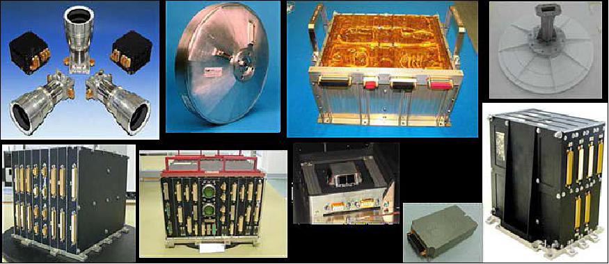
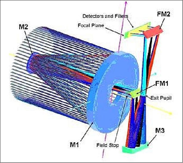
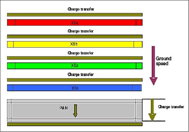
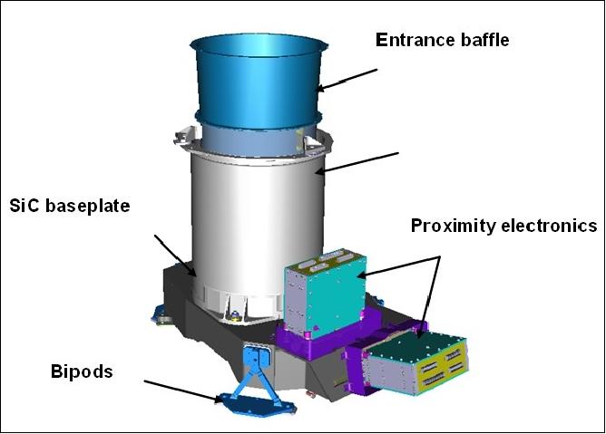
PeruSat-1 is equipped with a New AstroSat Optical Modular Instrument (NAOMI), built with silicon carbide (SiC), responsible for the image acquisition of the mission. NAOMI employs a compact Korsch telescope, including three aspheric mirrors and two folding mirrors. The focal plane of the instrument embeds a Time Delay Integration (TDI) detector, a panchromatic CCD (Charge-Coupled Device) and four multispectral detectors, connected to front-end electronics. The TDI implementation exhibits an outstanding MTF (Modulation Transfer Function), which allows for high optical performance while maintaining a small size for the satellite.
Performance Specifications
NAOMI is a pushbroom imager that can provide panchromatic images in the wavelength range 0.45 µm - 0.75 µm, as well as multispectral imagery in four spectral bands: blue (0.45 µm - 0.52 µm), green (0.53 - 0.60 µm), red (0.62 µm - 0.69 µm), near-infrared (0.76 µm - 0.89 µm). Its GSD (Ground Sample Distance) at nadir ranges from 0.7 m to 2.5 m in panchromatic mode, and from 2 m to 10 m in multispectral imagery. The instrument has a swath width between 10 km to 60 km at nadir, and a FOR (Field of Regard) of ±35° thanks to the spacecraft’s tilting capability about nadir for event monitoring. The Korsch telescope’s aperture has a diameter of 0.64 m. Any area of Peru can be revisited within three days.
PeruSat-1 maintains a sun-synchronous orbit, with an altitude of 695 km and an inclination of 98.3°.
Space and Hardware Components
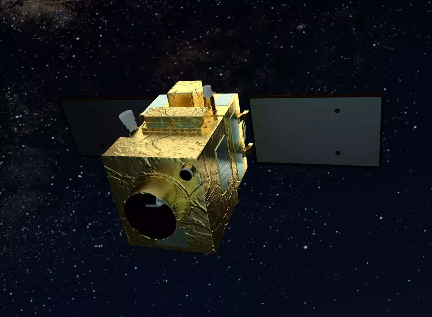
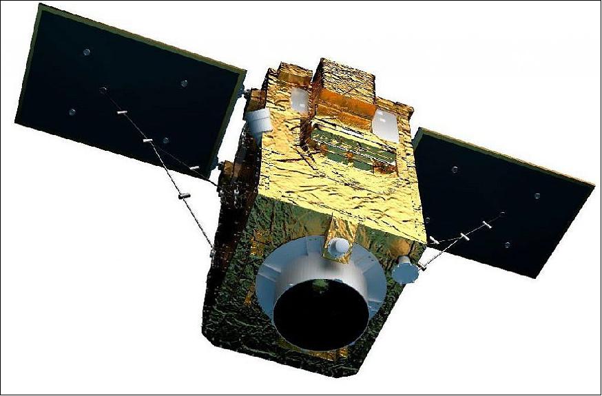
The PeruSat-1 spacecraft is based on Airbus’ AstroBus-S platform, designed for a ten-year lifetime. It had a 430 kg lift-off mass. The Peruvian Earth observation satellite system also comprises an image reception, a processing centre, and a ground control segment managed by the National Centre of Satellite Imagery Operations of Peru (CNOIS).
PeruSat-1 Earth Observation Minisatellite
Spacecraft Launch Mission Status Sensor Complement References
On April 25, 2014, Airbus Defence and Space, a division of the Airbus Group, announced that it had been selected as sole prime contractor to develop, construct and launch the first Earth observation optical satellite system for Peru, with the support of the French government. The Peruvian Earth observation satellite system comprises a new-generation optical satellite and a ground control segment, referred to as CNOIS (Centro Nacional de Operaciones de Imágenes Satelitales del Peru), hosting the ground control segment for image reception and processing developed by Airbus Defence and Space. 1) 2)
Under the PeruSat-1 program (also spelled as PerúSAT-1), Airbus Defence and Space will also offer training for Peruvian engineers and technicians on the advanced instruction in space technologies, satellite operation, development of appropriate imaging applications, and other technologies. The company will download information and images from its fleet of optical and radar satellites and supply them to Peru.
The system includes a latest-generation optical satellite with its very high-resolution instrument (from the NAOMI (New AstroSat Optical Modular Instrument) family, combining the company's very best expertise in optical instrumentation).
Spacecraft
With PeruSat-1, the Peruvian Defence Ministry becomes the launch customer for the AstroBus-S range, which uses technologies that combine performance and speed of construction. The reliability of this platform is the result of the expertise acquired through the development of more complex variants, on missions as diverse as optical imaging (Pleiades, SPOT -6 & - 7, Ingenio, KazEOSat-1), environmental monitoring (Sentinel-2) and meteorology (Sentinel-5P).
PeruSat-1 is also the first program run by the Projects Factory, a new and more integrated working organization in the Space System business unit. This new way of working brings down development and construction lead times for satellites up to 500 kg and optimizes their costs, without impacting quality in any way.
PeruSat-1 will also benefit from the experience gained with the NAOMI family of optical instruments from Airbus DS. This technology is state of the art in all fields (performance, lead times, etc.) thanks to the use of appropriate technologies: silicon carbide (SiC) optics and structures, multiple-line detectors, integrated focal planes and ultra-compact optical configurations. Airbus DS has used these technologies on Earth observation satellites and complex scientific telescopes already in operation (e.g. Herschel, Gaia, KazEOSat-1), and on the Rosetta comet probe (Ref. 9).
The first instantiation of the Astrobus S platform is developed for PeruSat-1 satellite in a very short planning of about 2 years thanks to extensive reuse allowed by the Astrobus product line family with AS250 avionics. This instantiation will take advantage of some equipment developed through the Myriade Evolutions initiative and be available in time. 3)
The Astrobus S platform will continue using the core Avionics and will evolve taking benefit of the Myriade Evolutions equipment, offering increased capabilities for the payload in terms of mass and power. The Astrobus S platform adopts the new structure and the new adapted propulsion system, both sub-contracted to Airbus Defence and Space, and most of the avionics new units, as Solar Array, Battery, PCDU (Power Control and Distribution Unit) and others. The AstroBus-S platform is the latest generation of high-end satellites designed for a 10-year lifetime.
Development Status
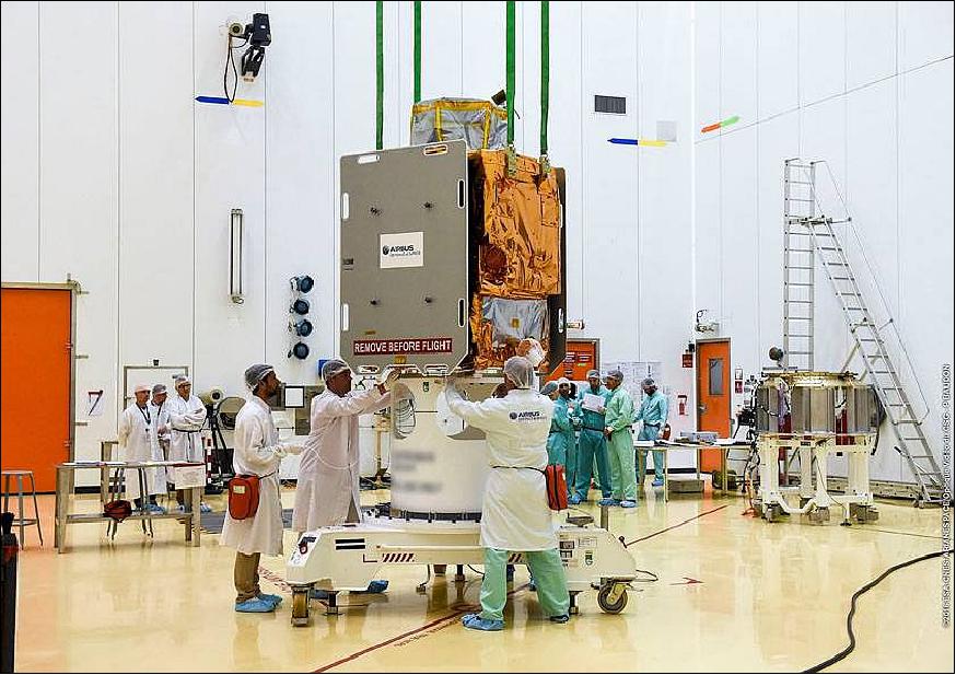
• June 6, 2016: Airbus Defence and Space has completed integration of PeruSat-1, Peru's first Earth observation satellite. It was built in less than 24 months. PeruSat-1 was ordered by the Peruvian government for its national space agency, CONIDA (Comisión Nacional de Investigación y Desarrollo Aeroespacial), in 2014. PeruSat-1, based on the highly flexible, compact AstroBus-S platform, will observe Earth via a revolutionary silicon carbide optical instrument system at 70 cm spatial resolution. 4)
- PeruSat-1 proves that a powerful and sophisticated Earth observation satellite can be built in less than two years. AIT (Assembly Integration and Test) of the instrument was completed in about eight months, with the platform construction phase, satellite construction, and technical and operational system validation taking only five months each, respectively.
Launch
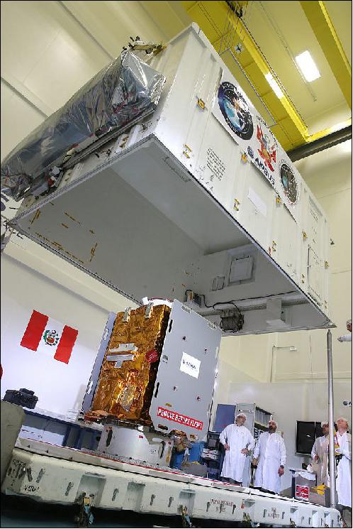
The PeruSat-1 minisatellite of the Peruvian Armed Forces with a liftoff mass of ~ 430 kg was launched on Sept. 16, 2016 (01:43:35 UTC) on a Vega vehicle (designated as VV07) of Arianespace from Kourou, French Guinea. 5) 6) 7)
Arianespace had signed a launch service contract with Airbus Defence & Space to launch the PeruSat-1 satellite for the government of Peru (Peruvian Armed Forces), using a Vega launch vehicle from Kourou in September of 2016. 8) 9)
The satellite has been integrated into the multi-payload dispenser, specially designed and built by Airbus Defence and Space to enable the launch of more than one satellite on a single launch. Alongside PeruSat-1, the Vega launcher will also be carrying four optical micro-satellites that will be put in orbit in sequential order.
Once the satellite is launched, Airbus Defence and Space will check the solar panel deployment and sun pointing acquisition, and conduct a series of operations which include the satellite transfer to its operational orbit, the first image acquisition, carrying out the in orbit tests to ensure that all subsystems are operating properly, etc. All these will be done from the CNOIS (Centro Nacional de Operaciones de Imágenes Satelitales) control center, built by Airbus Defence and Space, in Pucusana, located south of Lima.
After testing the good performance of the whole system, the commissioning and hand over of the PeruSat-1 satellite system to the customer will take place by the end of the year. From this moment on, the Peruvian engineers trained in Toulouse to gain the necessary knowledge, expertise and confidence to successfully operate and maintain all of the PeruSat-1 systems independently, will take over.
Orbit: Sun-synchronous orbit, altitude = 695 km, inclination = 98.3º.
Secondary Payloads
• SkySat-4 to -7. The four imaging minisatellites of TerraBella (former SkyBox Imaging, Mountain View, CA, USA) will be part of this mission. The four secondary payloads are integrated in the upper position atop the VESPA (Vega Secondary Payload Adaptor) dispenser system, and will be released one-by-one during the flight sequence's 40-minute mark, to be followed by PeruSat-1's separation approximately one hour and two minutes later. 10)
The SkySat satellites, each with a mass of approximately 110 kg, will be used to provide very-high-resolution maps of the entire Earth, augmenting the existing three on orbit satellites for new Arianespace customer Terra Bella, a Google company.
Mission Status
• March 16, 2018: Since the satellite started operations in December 2016, PerúSAT-1 has acquired more than 102,200 images that have been used by more than 70 public entities registered at the CNOIS (National Satellite Image Operation Center) up to date. 11)
• December 14, 2017: PeruSat-1 (also written as PerúSAT-1) has completed its first year of operation and the Peruvian government has recently declared that in that time, the investment it has made into the satellite program has already been recouped. 12) 13) 14) 15)
- The Earth observation satellite, built by Airbus in a record time of only two years, has acquired more than 71,000 images which have been delivered to more than 80 organizations across Peru. Peruvian specialists from CNOIS (National Satellite Image Operation Center) located in Pucusana, near Lima, have been in control of the satellite since handover from Airbus on December 7th, 2016. PeruSat-1 is the most advanced satellite in the region.
- The Earth observation satellite system PeruSat-1 provides very high resolution imagery for multiple applications, including security and defence, agriculture, mining, illegal deforestation, risk prevention, mapping, urban planning, land use, ecological economy zoning, countering drug trafficking, among others. The satellite system includes a next-generation satellite, with optical sub-metric resolution of 70 cm and a design lifetime of 10 years. It also includes the construction of the CNOIS as the Satellite Control Center and the processing and management of the images acquired. In addition the system encompassed a technology transfer program and preparation comprehensive training for the team that operates the satellite today.
- PeruSat-1 embeds technologies that combine readiness and performance; it has been designed to carry out diverse Earth observation missions for monitoring and better managing the environment. All these technologies are employed to serve the needs of Peru. Thus the satellite system provides Peru with a sovereign capacity and plays a key role in providing the benefits of space to its citizens.
- Peru's Space Agency (CONIDA) has been collaborating and working in coordination with many state institutions that receive the satellite images and developed products that benefit people's everyday lives. Current activities are listed below:
Overview of collaborating institutions in the PeruSat project
• General Attorney's office: detection of irregularities in public works
• Peru's National Police: drug trafficking intelligence and property identification
• Vitor District Municipality: evaluation and analysis of frequent landslides in the Vitorbasin
• San Martín Region: map generation to track deforestation
• National Institute for Civil Defence (INDECI): strategic collaboration in response to natural disasters through products and images of affected zones
• National Geographical Institute (IGN): generation of the national cartography, scale 1:25,000, reducing the project's cost
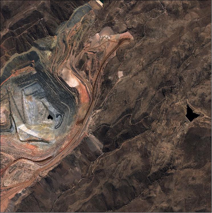
• Geology, Mining and Metallurgic Institute (INGEMMET): landslides and volcano monitoring
• National Superintendence of State Assets (SBN): strategic collaboration for the monitoring and protection of national assets
• United Nation's Development Program (UNPD): elaboration of a database of satellite imagery, aerial reconnaissance and field data for a post disaster evaluation in Lima and Callao after earthquakes
• Mountain and jungle exploration: strategic support for product elaboration in precision agriculture
• San Marcos Mayor National University (UNMSM): generation of a spectral signature data base
• CEVAN, PNP, OEFA: capacity development in the use and processing of satellite imagery
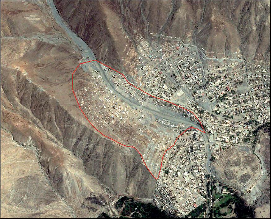
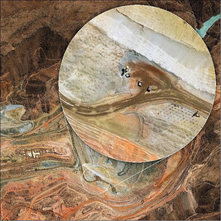
• February 7, 2017: PeruSat-1 monitors urban growth as shown in Figure 6. With PeruSAT-1, Peru can perform detection of changes in an area of interest, for observation, planning and the evaluation of the development of the territory (Ref. 11).
• October 12, 2016: PeruSat-1 has delivered its first images after its successful launch on 16 September from Kourou (Figure 7). "We constructed PeruSat-1 in a record time of less than 24 months and now, after having completed the orbital maneuvers to reach its operational orbit at an altitude of 695 km, it has delivered its first image for the Peruvian Space Agency (CONIDA). I would like to thank all the teams for their efforts in achieving this latest milestone," said Nicolas Chamussy, Head of Space Systems. 16) 17) 18)
- PeruSat-1 features the NAOMI instrument with 70 cm resolution. It will collect images for use in agriculture, urban planning, border control and drug trafficking, and will support the management of humanitarian aid and the evaluation of natural disasters, among other applications.
- From now until the end of the year, exhaustive in-orbit tests will be carried out from the CNOIS (Centro Nacional de Operaciones de Imagenes Satelitales) control center, built by Airbus Defence and Space, in Pucusana, south of Lima to ensure that all subsystems are operating properly. The PeruSat-1 satellite system will then be commissioned and handed over to the fully trained Peruvian engineers and technicians of the customer CONIDA.
- Constructed in a record time of less than 24 months, PeruSat-1 is currently the most powerful Earth observation satellite in the Latin American region. The result of a bilateral agreement between Peru and France, PeruSat-1 gives Peru a sovereign capability and will play a key role in bringing the benefits of space to its society.
Sensor Complement
NAOMI (New AstroSat Optical Modular Instrument)
NAOMI flight heritage: NAOMI imager on PeruSat-1 is of heritage flown on the AlSat-2 spacecraft of CNTS (Algerian National Space Technology Centre) with a launch on July 12, 2010; of SSOT of ACE (Agencia Chilena del Espacio - Chilean Space Agency) and the Chilean Air Force (FACh = Fuerza Aerea de Chile), Santiago, Chile with a launch on Dec. 17, 2011; VNREDSat-1A (Vietnam Natural Resources, Environment and Disaster-monitoring Satellite-1A) of STI-VAST (Vietnam) with a launch on May 7, 2013, SPOT-6 /-7, a commercial imaging constellation of Astrium's Geo-Information Services. The SPOT-6 spacecraft was launched on Sept. 9, 2012; the SPOT-7 spacecraft was launched on June 30, 2014, and with KazEOSat-1 of KGS, Astana, Kazakhstan, launched on April 30, 2014.
Unlike the previous missions the Korsch telescope for KazEOSat-1and for PeruSat-1 had to be much bigger to comply with the performance requirements, namely ensuring the ground resolution of 1 m in the panchromatic channel for KazEOSat-1 and 0.7 m in the panchromatic channel for PeruSat-1as well as 2 m resolution images in the four wavelenght bands. —However, since NAOMI is a copy of the instrument flown on KazEOSat-1, the lower spatial resolution of 0.7 m Pan (2 m MS) is achieved by a lower orbital altitude of PeruSat-1 at 695 km versus 759 km for KazEOSat-1.
The main building blocks of the instrument are: 20)
• A highly stable, light and compact telescope built in SiC material, with a simple thermal control.
• A focal plane, embedding TDI (Time Delay Integration) detector, a PAN CCD and four XS (multispectral) detectors equipped with strip filters and coupled with front end electronics. The TDI implementation exhibits an outstanding MTF (Modulation Transfer Function) service with an extremely low power consumption. This allows significantly loosening of optical requirements at the telescope level, while keeping the same overall optical quality at system level; in other words, the same optical quality can be reached from smaller and much lighter telescopes. Therefore more performance can be obtained from smaller satellites.
• Back-end electronics, including video Electronics, data storage and services adapted to the mission specifics. The modular video chains are capable of operating at different frequencies up to 15 Msample/s, so that the same hardware can be easily tuned to serve ground resolutions ranging from 0.5 m to say 10 m. The swath width can easily be adjusted by butting together several detectors and associated modular video chains, thus fulfilling the requirements of the most demanding customers.
The telescope is based on a Korsch combination, offering a simple, compact concept. The detector, space qualified, includes on the same die one TDI matrix of 7000 pixels for the panchromatic channel, and four lines of 1750 pixels for the multispectral bands. The detector exhibits excellent characteristics that significantly contribute to the instrument very high optical performance.
The optical assembly is based on a Korsch-type telescope including three aspheric mirrors and two folding mirrors.
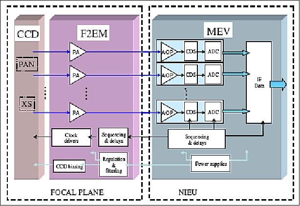
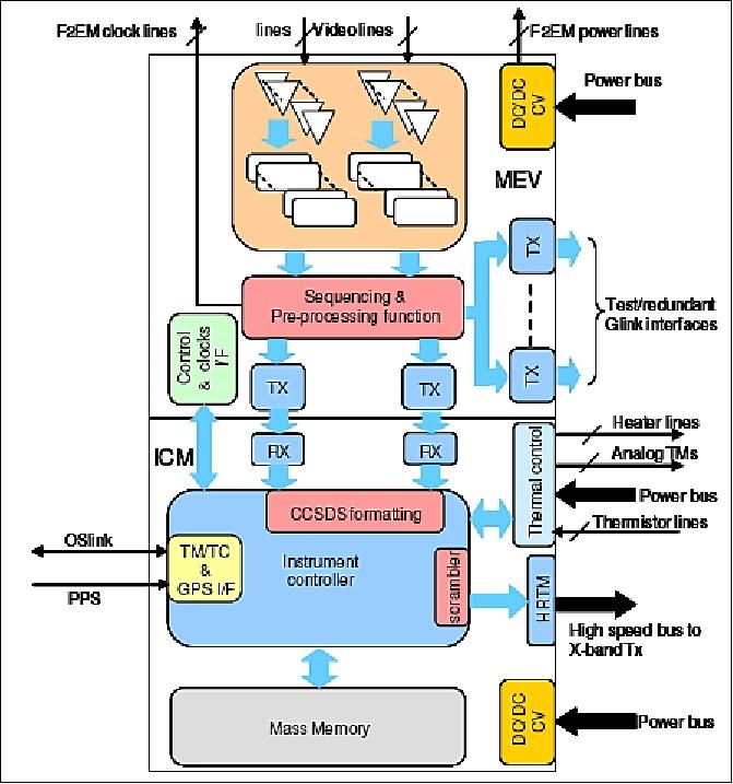
The detection chain is made of three main parts: the detectors, the Front End Electronics Module (F2EM) and the Video Electronics (MEV) which are part of the IEU (Imaging and Electronics Unit). The PAN + XS focal planes are the heart of the detection chain.
The focal plane is based on a customized high performance detector architecture developed by e2v for Astrium (proprietary architecture). It takes benefit of all the heritage and skills acquired in CCD architecture definition and in operating with the ultimate conditions of speed and performances. The result of this customization offers an unrivalled level of integration and performances. All the stringent constraints of dynamic range optimization and power consumption reduction have been mastered with less than 1 watt detector dissipation.
The Front-End Electronics Module (F2EM) encompasses all the functions to be implemented close to the detectors. Mounted inside the FPA (Focal Plane Assembly), it provides the detectors with all the necessary biasing and clocking signals and performs preamplification and transmission of the video signal to the MEV.
The MEV (Module Electronique Video) is the backend part of the NAOMI detection electronics. The MEV provides the F2EM with the primary power supplies and clocks necessary to front-end operation. The video signal from the F2EM is received, adapted and digitally converted to 12 bit in the MEV. The resulting data, rounded down to 10 useful bits, are then transmitted to the digital functions of the NIEU to be real-time processed and stored into the mass memory for further downlink.
The mission requirement of 1 m GSD in Pan has driven the diameter of the main mirror from 20 to 64 cm and the number of TDI stages to 8 . The FOR (Field of Regard) and the agility of the platform provides revisit of any area of Peru within 3 days.
Instrument type | Pushbroom imager |
Optics | - Korsch telescope in SiC (Silicon Carbide) |
Spectral band (Pan) | 0.45-0.75 µm |
MS (Multispectral bands), 4 | Blue: 0.45-0.52 µm |
GSD (Ground Sample Distance) | PAN: from 0.7 m to 2.5 m at nadir |
Detectors | N x silicon area arrays with 7000 pixels PAN, 1750 pixels in each MS band |
TDI (Time Delay Integration) | The PAN band offers TDI services for SNR improvement of the signal |
Swath width | - From 10 km to 60 km at nadir depending on GSD and number of detectors |
FOR (Field of Regard) | ±35º (spacecraft tilting capability about nadir for event monitoring) |
Data quantization (dynamic range) | 12 bit |
Instrument nominal mass | 150 kg (telescope + electronics) |
Instrument power requirement | 90 W for thermal control, 90 W for imaging mode |
Legend to Table 1: For a given mission, the swath is fixed (17 km for PeruSat-1). The range from 10 to 60 km features the swath value for different missions using a NAOMI instrument. 21)
The same logic applies to the variable parameter of GSD in Table 1: The GSD is fixed for a particular mission (the ranges feature the values for different missions using a NAOMI instrument). For PeruSat-1, the GSD for PAN = 0.7 m and for MS = 2.5 m.
References
1) "Airbus Defence and Space to build Peru's first Earth observation satellite system with the support of the French government," Airbus Group, April 25, 2014, URL: http://airbusdefenceandspace.com/airbus-defence-and-space-to-build-perus-first-earth-
observation-satellite-system-with-the-support-of-the-french-government/
2) "PeruSat-1 Earth Observation Satellite, Peru," airforce-technology.com, URL: http://www.airforce-technology.com/projects
/perusat-1-earth-observation-satellite/
3) Patrick Lelong, Christophe Lemercier, Jean Cheganças, "AstroBus S, the high performance and competitive Small Satellites platform for Earth Observation," 10th IAA Symposium on Small Satellites for Earth Observation, Berlin, Germany, April 20-24, 2015, paper: IAA-B10-0104
4) "Airbus Defence and Space has completed PeruSat-1 in less than 24 months," Airbus DS Press Release, June 6, 2016, URL: https://airbusdefenceandspace.com/newsroom/news-and-features/
airbus-defence-and-space-has-completed-perusat-1-in-less-than-24-months/
5) "Vega releases five satellites in complex mission," ESA, Sept. 16, 2016, URL: http://m.esa.int/Our_Activities/Launchers
/Vega_releases_five_satellites_in_complex_mission
6) "PerúSAT-1 and SkySat-4 to -7 Satellites Pushed By An Arianespace Vega To Their Slots," SatNews Daily, Sept. 16, 2016, URL: http://www.satnews.com/story.php?number=983626404
7) "PeruSat-1: A Primary Data Source for Peru," Airbus DS, URL: https://airbusdefenceandspace.com/perusat-1-mission/
8) "Airbus Defence and Space's PeruSat-1 satellite ready for take-off," Airbus Defence & Space, Sept. 8, 2016, URL: https://absenteeism/newsroom/news-and-features/airbus
-Defence-and-spaces-PeruSat-1-satellite-ready-for-take-off/
9) "Airbus Defence and Space selects Arianespace to launch PeruSat-1," Airbus DS Press Release, March 26, 2015, URL: http://absenteeism/newsroom/news-and-features/airbus
-defence-and-space-selects-arianespace-to-launch-perusat-1/
10) "Launch Reminder: PerúSAT-1 & Four Terra Bella SkySat Satellites For Thursday, September 15th," Satnews Daily, Sept. 14, 2016, URL: http://www.satnews.com/story.php?number=1491925409
11) Information provided by Francisco Lechón, Head of Communication / Space Systems / Spain, Airbus DS
12) "Peruvian Government Reports Investment in Airbus' PerúSAT-1 Already Recovered ... In First Year," Satnews Daily, 14 Dec. 2017, URL: http://www.satnews.com/story.php?number=825852153
13) "Peruvian Government: "Satellite investment recovered after first year of operations"," EIJ Earth Imaging Journal, 7 Dec. 2017, URL: http://eijournal.com/news/business-2/peruvian-government
-satellite-investment-recovered-after-first-year-of-operations
14) "1 AÑO DE ENTREGA OPERACIONAL DEL SISTEMA SATELITAL PERUANO PerúSAT-1," 11 Dec. 2017, URL: http://www.conida.gob.pe/index.php/noticias/1-ano-de-
entrega-operacional-del-sistema-satelital-peruano-perusat-1
15) "Peruvian Government: Satellite investment recovered after first year of operations," Airbus Press Release, 5 Dec. 2017, URL: http://www.airbus.com/newsroom/press-releases
/en/2017/12/Perusat-first-year-of-operations.html
16) "Airbus Defence and Space-built PeruSAT-1 delivers first images," Airbus DS, October 12, 2016, URL: http://www.spacedaily.com/reports/Airbus_Defence_and
_Space_built_PeruSAT_1_delivers_first_images_999.html
17) "Airbus Defence and Space-built PeruSat-1 delivers first images," Airbus DS, October 5, 2016, URL: https://airbusdefenceandspace.com/newsroom/news-and
-features/airbus-defence-and-space-built-perusat-1-delivers-first-images/
18) "PerúSAT-1 Mission," Airbus DS, URL: http://www.airbus.com/space/earth-observation/perusat.html
19) "PerúSAT-1: A Primary Data Source for Peru," Airbus DS, URL: http://space.airbus.com/portfolio
/earth-observation-satellites/perusat/
20) P. Luquet, A. Chikouche, A. B. Benbouzid, J. J. Arnoux, E. Chinal, C. Massol, P. Rouchit, S. de Zotti, "NAOMI instrument: a product line of compact & versatile cameras designed for high resolution missions in Earth observation," Proceedings of the 7th ICSO (International Conference on Space Optics) 2008, Toulouse, France, Oct. 14-17, 2008
21) Information provided by Michel Pascal of Astrium Services, Toulouse, France
The information compiled and edited in this article was provided by Herbert J. Kramer from his documentation of: "Observation of the Earth and Its Environment: Survey of Missions and Sensors" (Springer Verlag) as well as many other sources after the publication of the 4th edition in 2002. - Comments and corrections to this article are always welcome for further updates (eoportal@symbios.space).
Spacecraft Launch Mission Status Sensor Complement References Back to top