EO
Ocean
Multi-purpose imagery (ocean)
High resolution optical imagers
The Planet Flock Imaging Constellation, developed by Planet Labs, is designed to observe Earth by using a flock of several small satellites, named RapidEye, SkySat, and Dove, to collect images. The first satellite was launched in August 2008.
Quick facts
Overview
| Mission type | EO |
| Agency | Planet |
| Mission status | Operational (nominal) |
| Launch date | 09 Jan 2014 |
| Measurement domain | Ocean, Land |
| Measurement category | Multi-purpose imagery (ocean), Multi-purpose imagery (land) |
| Measurement detailed | Land surface imagery, Land surface topography |
| Instruments | CCD camera |
| Instrument type | High resolution optical imagers |
Planet - Flock Imaging Constellation
Overview
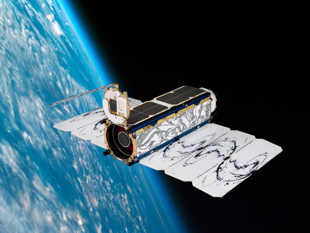
The Flock Imaging Constellation was developed by Planet Labs, a private startup based in San Francisco, California, founded in 2010 by NASA alumni Chris Boshuizen, Will Marshall, and Robbie Schingler, who sought to transform the space industry through innovative Earth observation solutions. The constellation’s core are the “Dove” nanosatellites, which are designed to be low-cost, rapidly deployable, and capable of delivering Earth images with a spatial resolution of 3–5 meters. 3)
Each Dove satellite is a compact 3U CubeSat (~30 cm long) equipped with a multispectral optical imaging payload capable of capturing visible and near-infrared bands. The satellites operate in Sun-synchronous orbit and utilise onboard processing and agile attitude control to optimize imaging efficiency and revisit rates. Their design emphasizes scalability and cost-effectiveness, enabling Planet Labs to launch large numbers frequently and maintain near-daily global Earth coverage. 104)
Planet Labs first launched four prototype Dove satellites (Dove 1, 2, 3, and 4) in 2013, validating the technology and paving the way for rapid expansion. This success led to the deployment of Flock 1 in 2014, a fleet of 28 nanosatellites, the largest Earth imaging constellation ever launched at the time. In March 2014, Planet Labs announced the launch of the first 100 Flock satellites. 1) 2)
Over subsequent years, Planet Labs continued to expand the Flock constellation, launching additional Dove satellites with enhanced imaging capabilities, faster onboard processing, improved attitude control, and longer operational lifespans. The scalable architecture allows Planet to provide highly frequent revisit rates, sometimes multiple times per day over targeted areas, making it ideal for agriculture, forestry, disaster response, and environmental monitoring applications. 103)
In addition to the Dove nanosats, Planet Labs expanded its portfolio with the acquisition of the RapidEye constellation, launched between 2008 and 2011, comprising five medium-resolution satellites providing 5-meter multispectral imagery. The company also developed the SkySat constellation, with its first satellite launched in November 2013, featuring high-resolution imagery at up to 50 centimeters per pixel, supporting commercial and government customers with frequent revisit times and enhanced spatial detail. 103)
Spacecraft
The Flock 1 constellation nanosatellites (all 3U CubeSats) were designed and built by Planet Labs Inc. They feature mostly COTS (Commercial-off-the-Shelf) components, including their imagers. Each nanosatellite has a mass of ~5 kg and a size of 10 cm x 10 cm x 34 cm.
It can be expected, that the Flock 1 nanosatellite design corresponds closely to the design of the prototype Dove series, which demonstrated that the company’s engineers can accurately position the orbiters and capture a continuous stream of imagery with a resolution of 3-5 m.
ADCS (Attitude Determination and Control Subsystem): The attitude is sensed by magnetometers, gyros and photodiodes. The attitude is being controlled by magnetorquers and reaction wheels. The B-dot controller makes use of the B field to reduce the angular rate of the satellite. In this control mode, Dove-1 therefore behaves as a permanent magnet, remaining locked and axis-aligned to the Earth’s magnetic field. - Dove-1 will be nadir pointing twice per orbit. The alignment of the magnetic field is known to about 1º at any point.
EPS (Electrical Power Subsystem): The bus provides central power control through a power supply to the camera, the flight computer and the magnetorquers. The power supply regulates the voltages and ensures a stable power supply to each component. Power storage is provided by 8 Lithium-ion cells, providing 20 Ah of charge at full capacity. The batteries will be recharged by body-mounted TASCs (Triangular Advanced Solar Cells).
C&DH (Command & Data Handling) subsystem: C&DH is controlled by the single board computer. Additionally there will be a discrete watchdog board that will be able to reboot the flight computer in the event of errors.
RF communications
The communication subsystem consists of a VHF radio beacon for transmitting telemetry and an S-band frequency hopping spread spectrum modem for two-way communication and as the primary radio for data downloading. After powering up, the first mission event is to transmit telemetry data over the VHF beacon. The beacon will transmit health packets (including temp/power supply/current/RSSI/solar vector/acceleration) at 1200 baud AFSK approximately every 30 seconds (AX.25 protocol, 145.825 MHz). The beacon can transmit at up to 1 W and will use a quarter wave monopole antenna cut from tape measure.
The S-band radio will operate in the 2.4 GHz half-duplex ISM (Industrial, Scientific and Medical) band at a wireless link rate of 115 kbit/s using a patch antenna.
In Nov. 2013, Planet Labs' Flock 1 nanosatellites were delivered to NASA's Wallops Flight Facility in Virginia for launch on board an Antares rocket in December 2013. These satellites were built in production at the Planet Labs headquarter offices in San Francisco. Planet Labs is on track to launch 32 satellites on four different launches in 2013. 5)
Radio Development History(update to RF communications)
In order to meet Mission 1 data volume objectives, Planet built a custom high-speed X-band radio using COTS components that is tightly integrated with the rest of the CubeSat bus. Several radio architecture decisions were made in order to meet the size, weight, and power (SWaP) constraints of the CubeSat platform while also improving the overall system efficiency. For example, the final stage RF power amplifier was integrated adjacent to the antenna to improve the total system power efficiency. This allowed the use of antenna solutions with 10-12 dBi gain, but still achieve data rates comparable to much larger class satellites that typically have very high gain antennas.
The custom development solution also allowed for rapid prototyping and repeated iterations that led to continuous improvements to the radio subsystem. Planet's first satellite launch hosted the sixth iteration (Build 6) of the spacecraft that transmitted 2 W of RF power through a 3 dBi gain patch antenna. A 6.1 m dish at the Chilbolton Observatory in the UK served as the ground station antenna. On April 25, 2013, Planet achieved its first successful X-band downlink at 4 Mbit/s data rate, which set a new data rate record for CubeSat class satellites.
The success of the early launches and tech demos proved that Planet could meet its Mission 1 goals by following the \agile aerospace" philosophy of rapid prototyping, repeated iterations, and continuous improvements. Less than three years after the first launch, the thirteenth iteration (Build 13) of the satellites was launched on the Indian Polar Satellite Launch Vehicle (PSLV) in June 2016. This constellation code named Flock 2P or F2P included twelve \Build 13" satellites (launch in June 2016). Further improvements were made to this build and Flock 3P or F3P consisting of 88 satellites was launched in February 2017. With the F3P launch, Planet set a record for the most number of operational satellites (100 Build 13 satellites and several B10, and B12 satellites). Planet has demonstrated 220 Mbit/s peak data rates with the Flock 3P constellation and average data rates of approximately 160 Mbit/s. Cumulatively, these satellites generate several TB of imagery data daily that is downlinked to eight geographically diverse ground station sites.
Improvements to the spacecraft HSD (High-Speed Data) system have followed Planet's iterative design approach. Higher gain antennas have been added and improved, RF circuit impairments have been addressed, amplifier settings have been optimized, and the radio firmware and software has undergone constant development. Table 1 provides a summary of key HSD development milestones. 6)
Date | Milestone | Build#,HSD# | Improvements |
Apr. 21, 2013 | Dove 1 | B6, HSD1 | HSD1 with operational X-Band system with patch antenna (3 dBic), achieved 4 Mbit/s using QPSK modulation scheme at 1/2 FEC rate. |
Nov. 21, 2013 | Dove 3 | B8, HSD1 | Upgraded system with ACM (Adaptive Coding and Modulation), high gain helical antenna (10 dBic), achieved 25Mbit/s using 8PSK modulation at 8/9 FEC rate. |
June 19, 2014 | Flock 1c (11 satellites) | B9, HSD1 | Increase symbol rate from 10 Mbaud to 20 Mbaud and achieved 34 Mbit/s using QPSK modulation at 8/9 FEC rate |
June 1, 2016 | Flock 2e (12 satellites) | B12, HSD1 | Increased symbol rate to 24 Mbaud, improved helical antenna (12 dBic), optimized and linearized the X-Band transmitter chain and achieved 100 Mbit/s using 32 APSK modulation and 8/9 FEC rate |
June 21, 2016 | Flock 2p (12 satellites), | B13, HSD2 | HSD2 with new hardware, firmware, and software improvements on satellite and ground station, symbol rate increased from 24 Mbaud to 70 Mbaud, achieved 220Mbit/s using 16 APSK modulation and 3/4 FEC rate (Raw RF link rate achieved 283 Mbit/s) |
The HSD radio operates at X-band with a center frequency of 8150 MHz and 70 Mbaud symbol rate. This frequency is within the 8025-8400 MHz (X-band) range where EESS (Earth Exploration Satellite Service) has a primary spectrum allocation.
Launches
Spaceraft Name | Launch Vehicle | Launch Date (UTC) | Number of satellites launched | Status |
|---|---|---|---|---|
Dove 2 | Soyuz 2.1b | April 19, 2013 | 1 | Retired |
Dove 1 | Antares | April 21, 2013 | 1 | Reentered |
Dove 3 | Dnepr | November 21, 2013 | 1 | Retired |
Dove 4 | Dnepr | November 21, 2013 | 1 | Failed Deployment |
Flock 1 | Antares | January 9, 2014 | 28 | Reentered |
Flock 1c | Dnepr | June 19, 2014 | 11 | Retired |
Flock 1b | Antares | July 13, 2014 | 28 | Reentered |
Flock 1d | Antares | October 28, 2014 | 26 | Failed Launch |
Flock 1d’ | Falcon 9 | January 9, 2015 | 2 | Reentered |
Flock 1e | Falcon 9 | April 13, 2015 | 14 | Reentered |
Flock 1f | Falcon 9 | June 28, 2015 | 8 | Failed Launch |
Flock 2b | H-IIB | August 19, 2015 | 14 | Reentered |
Flock 2e | Atlas V | December 6, 2015 | 12 | Operational |
Flock 2e’ | Atlas V | March 23, 2016 | 20 | Operational |
Flock 2p | PSLV | June 22, 2016 | 12 | Operational |
Flock 3p | PSLV | February 15, 2017 | 88 | Operational |
Flock-3p' | PSLV | January 12, 2018 | 4 | Decayed |
Dove Pioneer | Rocket Lab Electron | January 12, 2018 | 1 | Decayed |
Flock-3r | PSLV | November 29, 2018 | 16 | Operational |
Flock-3s | Falcon 9 | December 3, 2018 | 3 | Operational |
Flock 3k | Soyuz Rocket | December 27, 2018 | 12 | Operational |
Flock-4a | PSLV | April 1, 2019 | 20 | Operational |
Flock 4p | PSLV | November 27, 2019 | 12 | Operational |
Flock-4e | PSLV | July 4, 2020 | 5 | Failed Launch |
Flock-4v | Vega | September 3, 2020 | 26 | Operational |
Flock 4e’ | Rocket Lab Electron | October 28, 2020 | 9 | Operational |
Flock 4s | Falcon 9 | January 24, 2021 | 48 | Operational |
Flock 4y | Falcon 9 | January 3, 2023 | 36 | Operational |
Flock 4x | Falcon 9 | January 13, 2023 | 44 | Operational |
Flock 4q | Falcon 9 | November 11, 2023 | 36 | Operational |
Flock 4BE (Tanager-1) | Falcon 9 | August 16, 2024 | 36 | Operational |
Flock-4g | Falcon 9 | January 14, 2025 | 36 | Operational |
Flock-4h | Falcon 9 | November 28, 2025 | 36 | Operational |
Orbit
Item | ISS Orbit | SSO Orbit |
Sun angle | Varies over time | Consistent based on LTAN/LTDN, Can drift over several years |
Thermal environment | Solar beta angle maxima require special handling | Minor variation over the year |
Orbital altitude | 390 km - 450 km at deployment | About 500 km |
Inclination | 51.6º | ~98º |
Orbit lifetime | 12-18 months (depending on solar activity and drag profile) | 4-5 years |
Coverage | Missing northern Canada and Russia, Antarctica, southern tip of South America | Full Earth with some seasonal polar gaps |
Figure 7: A closer look at the tech infrastructure that gets an image from a satellite in space down to you your computer (Video credit: Planet Labs)
Mission Status
• November 28, 2025: Planet launched Flock-4h, consisting of 36 new Dove satellites, aboard SpaceX’s Transporter-15 Rideshare Mission, from Vandenberg Space Force Base, SLC-4E, in California. The Falcon 9 vehicle took off at 18:44 UTC. 101) 102)
• January 14, 2025: Planet launched 36 more of its 3U SuperDoves of Flock 4G into orbit. The Falcon-9 rockets took off from Space Launch Complex 4E (SLC-4E) at Vandenberg Space Force Base in California at 19:09 UTC. 100)
• August 16, 2024: Planet Labs launched their first Hyperspectral Satellite Tanager-1 today, together with 36 satellites which are part of their Flock 4BE SuperDove satellites, onboard a Falcon-9 rocket as part of SpaceX’s Transporter-11 Rideshare mission. The launch took place at 18:56 UTC from Vandenberg Space Force Base, California. Tanager-1 aims to provide hyperspectral data to both Planet and Carbon Mapper.
• November 11, 2023: Planet Labs has announced that Pelican-1, the first tech demo satellite for the company’s next-generation, high-resolution Pelican fleet, along with 36 of its SuperDoves, Flock 4Q, were successfully launched to orbit on SpaceX’s Transporter-9 mission from Vandenberg Space Force Base . The Planet team has successfully made contact with each satellite and started its commissioning process. 95)
• November 17, 2021: Planet collaborates with New Light Technologies Inc. (NLT) to provide the Federal Emergency Management Agency (FEMA) with high-cadence and high-resolution satellite data, enhancing situational awareness for disaster response. Utilizing PlanetScope and SkySat satellites, the data supports predictive deep learning models for tornado damage, flood assessments in Texas, and visual evaluations of infrastructure damage caused by winter storms. Planet's archive imagery, dating back to 2009, enables before-and-after comparisons within 24 hours of catastrophic events, aiding FEMA in targeted relief efforts and long-term risk mitigation. The collaboration aligns with Planet's mission to support global communities by revealing near-daily global change, and it comes as part of Planet's merger agreement with dMY Technology Group, Inc. IV, transitioning into a publicly-traded public benefit corporation committed to accelerating humanity toward a more sustainable, secure, and prosperous world. 14)
• November 10, 2021: Planet has entered into an agreement to acquire VanderSat, a leading provider of advanced earth data and analytics. VanderSat's innovative products focus on water management and crop health, utilizing insights drawn from NASA, ESA, and JAXA satellite data. With a mission to serve one billion hectares of land by 2024, VanderSat's expertise complements Planet's goal to bridge the gap between real-world problems and remote-sensing science complexity. The acquisition, valued at approximately $28 million, includes shares of Class A common stock and cash. This strategic move enhances Planet's capabilities in agriculture, civil government, insurance, and finance, providing richer insights and more precise measurements. The transaction is set to close in Q4 2021, subject to customary conditions and the completion of Planet's business combination with dMY Technology Group, Inc. IV. 15)
• October 12, 2021: At the Explore 2021 user conference, Planet unveiled two significant products: Pelican, a next-gen satellite fleet set to enhance high-resolution SkySat imagery with improved resolution, more frequent revisit times, and reduced latency; and Fusion with SAR, an enhancement to the existing Fusion Monitoring product by incorporating Synthetic Aperture Radar (SAR) data from Sentinel 1. Pelican promises increased response times and superior image resolution, aiming to exceed SkySat's market-leading global revisit frequency. Fusion with SAR enhances agricultural sensing by overcoming cloud cover limitations, offering continuous monitoring of crop health and critical events. Planet's agile aerospace methodology and modularity enable rapid innovation, and the Pelican design leverages the Carbon Mapper constellation. With the planned merger with dMY Technology Group, Inc. IV, Planet aims to go public, fueling its Earth data platform expansion. Pelican's size will be market-driven, aligning with Planet's strategy to meet evolving demand and broaden its user base for remote sensing science. 16)
• July 23, 2021: NASA has expanded its contract with Earth imagery companies Planet and Spire Global, enabling broader access to satellite data for scientific research across U.S. federal civil science agencies. Planet's contract modification provides access to its PlanetScope and RapidEye satellite constellations for agencies like NOAA, USGS, NSF, and their funded researchers. Meanwhile, NASA extended its contract with Spire Global under the Commercial Smallsat Data Acquisition (CSDA) program, allowing the delivery of a comprehensive catalog of data from Spire's Earth-orbiting small-satellite constellation. These datasets will be archived and available for scientific purposes to U.S. federal agencies and NASA-funded researchers through the Smallsat Data Explorer (SDX) tool. The move aims to facilitate research on Earth's changes and their impact. 18)
• July 7, 2021: Planet Labs Inc. and dMY Technology Group, Inc. IV (NYSE: DMYQ) have entered into a definitive merger agreement, marking Planet's transition into a publicly-traded company valued at approximately $2.8 billion upon closing. Planet, a leading Earth data and analytics provider, generates 25 terabytes of daily data from around 200 satellites, operating on a subscription-based model with over $100 million in revenue. The merger includes $345 million in dMY IV's trust account, a $200 million PIPE led by BlackRock, and notable participants like Koch Strategic Platforms, TIME Ventures, and Google. Planet plans to utilize the proceeds for expanding operations and services to foster a more sustainable and secure planet. The transaction is anticipated to conclude later this year, with Planet continuing under its name and listed on the NYSE as "PL." The merger aims to accelerate Planet's mission of utilizing space to benefit life on Earth, catering to diverse sectors such as agriculture, forestry, government, and mapping, fostering sustainability and environmental monitoring. The merger transaction aligns with Planet's strategic vision to leverage data for global sustainability and environmental action as data becomes increasingly pivotal in driving the global economy. Planet's management team, led by CEO Will Marshall, will continue to steer the public company after the merger. 19)
• January 27, 2021: Planet, leading an alliance named RapidAI4EO, has secured a competitive grant under the Horizon 2020 program to advance continuous land monitoring applications in Europe, within The Copernicus Program and Services. The consortium, comprising industry leaders like Planet, Vision Impulse, VITO, IIASA, and ONDA DIAS/Serco Italia, aims to enhance measurements of the human footprint on Earth, addressing UN Sustainable Development Goals. The team plans to develop improved AI processes, leveraging Copernicus satellite data and advanced Fusion Monitoring products from Planet. Focused on the CORINE Land Cover program, the project aims to detect and classify changes in land cover and use at a higher level of detail and temporal cadence, contributing to the evolution of the Copernicus Land Monitoring Service products. The resulting training sets will be open-sourced for the broader remote sensing community's benefit. 20)
Figure 11: Planet Fusion Monitoring, Planet’s first in a series of Fusion products that combine multiple data types and refine them into a single information stream, will be extensively used throughout the RapidAI4EO project (Video credit: Planet Labs)
• January 24, 2021: Planet has successfully deployed 48 SuperDove satellites, part of its Flock 4s, on SpaceX's Transporter-1 mission, marking a record-setting launch with 143 satellites. The Flock 4s introduces new spectral bands, enhancing image sharpness and quality. The 48 SuperDoves, combined with over 100 existing satellites, will contribute to providing unparalleled medium-resolution global coverage. The data generated can be applied across various sectors, addressing critical issues such as agriculture, government, intelligence, forestry, and land use. Planet's Mission Operations team has achieved a 100% success rate in the initial contact with the first set of 40 satellites, with the remaining 8 set to be deployed from D-Orbit's ION platform in the coming weeks. The deployment follows Planet's commitment to advancing satellite technology and contributing to solving global challenges.21)
• October 28, 2020: Rocket Lab has successfully launched nine SuperDove satellites, known as Flock 4e', aboard its Electron rocket from the New Zealand launch site. The SuperDoves were deployed into a Sun Synchronous Orbit at an altitude of approximately 500 km, joining the existing constellation. Equipped with eight spectral bands, these SuperDoves provide Earth imagery with precise surface reflectance values, facilitating advanced algorithms and time-series analysis. The interoperability of Planet's SuperDoves with publicly available imagery, such as Copernicus' Sentinel-2, allows for innovative applications and use cases. Planet's Mission Operations team has established contact with all nine satellites, which are currently undergoing commissioning. This mission, named "In Focus," marks Rocket Lab's 15th launch and the third time carrying Planet satellites. 22)
• September 10, 2020: Planet successfully launched 26 SuperDoves (Flock 4v) on Arianespace's VV16 SSMS-POC flight, expanding its existing fleet. The company has now shared the first light images from the new flock, reporting that all satellites are healthy and on track for full commercial service. This achievement maintains Planet's impressive 100 percent record of successfully contacting every satellite deployed in space, totaling 357 satellites. With the addition of the new SuperDoves, Planet will continue to offer medium-resolution multispectral imagery (3-5m) globally, providing valuable intelligence at an unprecedented cadence for customers and organizations worldwide. 23)
• September 3, 2020: The Vega rocket successfully launched 26 SuperDoves, Flock 4v, as part of Arianespace's VV16 SSMS-POC flight, marking a significant achievement for the smallsat industry. The launch demonstrated Arianespace's rideshare mission, deploying 53 satellites for 21 customers from 13 countries. The first 14 SuperDoves were successfully deployed into a 530 km Sun-synchronous orbit, with Planet's mission operations team initiating the commissioning process. The remaining 12 SuperDoves will be deployed in the coming weeks from D-Orbit's ION platform. The diverse range of passenger payloads includes maritime microsatellites, CubeSats for meteorology and Earth observation, communication minisatellites, and nanosatellites for monitoring greenhouse gas emissions and climate data. The return of the Vega rocket to flight after corrective actions and delays due to the COVID-19 pandemic marks a notable moment for the industry. 24) 25) 26)
• March 24, 2020: Planet has announced a strategic partnership with Seisan, a custom software solutions and systems integration company specializing in geospatial technologies. Through its status as a premiere Planet partner, Seisan aims to leverage Planet's high temporal resolution geospatial data to create innovative solutions and gain a competitive edge in various industry verticals. By integrating Planet's dataset, Seisan plans to develop machine learning imagery analysis, traditional systems integration, and data transformation techniques, providing an advanced level of geospatial awareness. This collaboration seeks to enable companies to extract greater insights from location data, leading to increased productivity, operational cost reductions, and enhanced situational awareness. Seisan expressed excitement about utilizing Planet's extensive image archive to analyze historical data without the constraints of traditional geospatial methodologies, highlighting the potential for disruptive solutions across multiple sectors. Planet's daily imaging capabilities and Seisan's expertise in technology and innovation are expected to result in high-quality solutions meeting the immediate needs of enterprise customers. 30)
• February 13, 2020: Planet is set to launch 26 SuperDove satellites, part of the Flock 4v constellation, on Arianespace's Vega rocket from the Guiana Space Center. Scheduled for March 23, 2020, the launch was subsequently delayed due to COVID-19. The SuperDoves will be split into two batches, with 14 housed in ISL’s QuadPack deployers and 12 deployed from D-Orbit's InOrbit Now (ION) platform. This marks the first flight of D-Orbit’s InOrbit Now (ION) system, with plans to verify technologies for potential future use as a "space tug" capable of orbit adjustments or accelerating satellite phasing. The mission, named "Small Spacecraft Mission Service—Proof of Concept," represents a dedicated rideshare, bringing together multiple small satellites for the same orbit. Planet expresses gratitude to its partners, including Arianespace, ISISpace, D-Orbit, Spaceflight, and SAB Aerospace , for their collaborative efforts in realizing the mission. 31)
• November 27, 2019: Planet successfully launched 12 SuperDove satellites, known as Flock 4p, into a 509 km Sun Synchronous Orbit using India's Polar Satellite Launch Vehicle (PSLV) from SDSC SHAR. The launch, which marked Planet's 25th successful mission, occurred alongside ISRO's primary payload, CartoSat-3. Following the launch, Planet's Mission Operations team achieved contact with all 12 satellites, initiating satellite phasing and commissioning processes. This achievement maintains Planet's remarkable record of a 100 percent success rate in establishing contact with each Dove satellite post-launch. The Flock 4p satellites are currently undergoing detumbling maneuvers, subsystem health checks, solar panel deployments, and imagery system calibration. 32)
• October 14, 2019: Planet has launched Planet Orbit, a partner program that provides customers with access to geospatial data and aims to transform various industries through its unique dataset. The program allows partners to leverage Planet's robust APIs, PlanetScope daily imagery, and high-resolution SkySat tasking to create powerful solutions and differentiate their business. The initiative includes Gold and Platinum levels, offering benefits such as a dedicated portal, partner enablement with training and tools, access to an exclusive community, and for Gold and Platinum partners, dedicated Partner Business Managers and joint marketing activities. 33)
• August 2019: Planet has developed the HSD2 (High-Speed Downlink 2), the latest generation compact, low-mass, and low-power radio for its 3U form-factor imaging CubeSats. The HSD2 operates at X-band and achieves a data rate over 1.6 Gbit/s on-orbit, overcoming previous downlink limitations imposed by tight size, weight, and power (SWaP) constraints. Built on the success of the previous generation HSD Dove radio, the HSD2 features dual circular polarization antennas, a compact volume of 0.25U, a DVB-S2 modulation scheme with adaptive modulation and coding rates, and a total DC power consumption of 50W during downlink. The ground station network, consisting of 15 owned S/X-band antennas across five sites, supports both HSD1 and HSD2 downlinks, with hardware and software upgrades to accommodate multiple channels and dual polarization.
• April 2, 2019: The RapidEye satellite constellation has officially retired, marking the end of its image collection operations. Despite the discontinuation of new imagery acquisition, the extensive archive of RapidEye data will remain accessible to customers for both commercial and noncommercial purposes. To address the transition, users of RapidEye imagery have the option to shift to Planet's Next-Generation PlanetScope products, offering enhanced spatial resolution and continuity across key spectral bands, including red, green, blue, near-infrared, and red-edge, ensuring a seamless and upgraded imaging experience. 39)
• March 21, 2019: The National Geospatial-Intelligence Agency (NGA) has extended its contract with Planet, a commercial satellite imagery provider, for a six-month option worth $5.9 million. The agreement aims to further the integration of high-revisit imagery and automated processing into NGA's analysis processes, leveraging Planet's commercial data to meet the evolving technical requirements of the National System for Geospatial Intelligence community. The subscription contract facilitates the delivery of new daily imagery over specific areas, including the U.S. Southern Command region and zones of interest in the U.S. Africa Command and U.S. Indo-Pacific Command areas of responsibility, supporting combatant commands in their missions and enhancing automated analytic systems for monitoring operational environments. 40)
• January 3, 2019: Planet has provided high-quality optical satellite imagery revealing the aftermath of the collapsed Anak Krakatau volcano, which triggered a devastating tsunami in December 2018. Despite challenging weather conditions over Indonesia's Sunda Strait, Planet's Dove and SkySat platforms captured detailed images showcasing the extent of the volcanic cone's failure. The imagery highlights the transformation of the island, showing a broken-open summit crater that has formed a small bay. The Indonesian disaster agency reports a significant loss of Anak Krakatau's volume, with assumptions that a substantial portion slid into the sea during the massive landslide that caused the tsunami. Planet's extensive satellite constellation, consisting of small Dove spacecraft and high-resolution SkySat platforms, enabled clear observations by maximizing ground visibility when clouds dispersed. The optical satellite images complemented initial radar data, providing crucial insights into the collapse of Anak Krakatau. The disaster claimed the lives of approximately 430 people along the coastlines of Java and Sumatra, with many more displaced. 41) 42)
• December 28, 2018: Twelve Flock -3k 3U imaging CubeSats (each ~ 5 kg) of Planet Labs, were part of the secondary payload launched on 27 December 2018 on the Kanopus-V No 5 and No 6 minisatellite flight of Roscosmos on a Soyuz-2.1a / Fregat-M vehicle from the Vostochny Cosmodrome in Russia. 43) 44)
• December 3, 2018: Three Flock-3s series 3U CubeSats and 2 SkySats were part of the SSO-A rideshare mission of Spaceflight Industries launched on 3 December 2018 (18:34:05 GMT) on a SpaceX Falcon-9 Block 5 vehicle from VAFB (Vandenberg Air Force Base) in California. 45) 46)
• November 29, 2018: 16 Flock-3r series 3U CubeSats were part of the payload of ISRO's PSLV-C43 vehicle from SDSC (Satish Dhawan Space Center) SHAR on the east coast of India. 47) 48)
• October 4, 2018: NASA has initiated a pilot program, the "Private Sector Small Constellation Satellite Data Product Pilot," to assess the viability of integrating Earth science data from commercial small-satellite constellations with observations from NASA's existing fleet of Earth science missions. The agency awarded sole-source contracts to three private sector organizations—DigitalGlobe (a Maxar Technologies company), Planet, and SPIRE Global. The contracts, valued up to $7 million each, aim to acquire and evaluate data sets from the private sector's Earth-orbiting small-satellite constellations. This innovative approach seeks to leverage the strengths of NASA's aging research satellite fleet and the growing number of small satellites launched by private industry, potentially enhancing the completeness of climate data sets. NASA will provide the obtained data to its researchers to assess whether it contributes to the agency's science and applications development goals, exploring the cost-effectiveness of complementing NASA's Earth observations with private sector observations. 49)
• September 12, 2018: Planet has inaugurated its new satellite manufacturing and testing factory in San Francisco, marking a significant expansion in its capabilities. The 27,000+ square-feet state-of-the-art complex is six times larger than the previous lab, consolidating all aspects of spacecraft design and production in one location, from R&D to manufacturing and testing. This enhancement is expected to facilitate faster iteration and advancement of small satellites. The facility's flexibility enables simultaneous production of multiple spacecraft lines, including Doves and future satellite constellations. Notable features include a multi-purpose environmental testing facility for simulating space environments and ensuring hardware readiness for flight, reinforcing Planet's commitment to maintaining quality and agility in satellite development. 50)
• August 2018: Planet has successfully achieved its "Mission One" of imaging the entire landmass of the Earth every day using its Dove satellites. As of June 2018, Planet operates approximately 190 Doves, with replenishment launches planned to maintain and improve the constellation. The company is now focusing on "Mission Two," which involves applying machine learning and analytics to enable users to query Earth's imagery and build customized information feeds. Planet's Mission Operations team, distributed between the US and Europe, plays a crucial role in maintaining the health and performance of the Dove constellation, collaborating closely with subsystem teams, particularly the Attitude Determination and Control Subsystem (ADCS). Through iterative processes and a bias toward automation, Planet aims to optimize the operation of its constellations with a focus on efficiency and data-driven decision-making. 51) 52) 53)
• June 25, 2018: Planet has entered a partnership with Airbus, a remote sensing company, to facilitate mutual access to their data and collaborate on developing geospatial solutions. The agreement aims to offer customers a comprehensive suite of global remote sensing data at various temporal and spatial resolutions. Airbus brings high-resolution remote sensing capabilities, while Planet contributes its global coverage and temporal cadence. Together, the companies plan to deliver sophisticated offerings across commercial markets, combining their strengths to address diverse customer needs. 54)
• January 21, 2018: Rocket Lab's Electron vehicle, named "Still Testing," successfully achieved orbit and deployed customer payloads on its second test flight. The launch, which took place from Rocket Lab Launch Complex 1 in New Zealand, included the deployment of a Dove Pioneer Earth-imaging satellite for Planet and two Lemur-2 satellites for Spire Global. The successful deployment of customer payloads on an early test flight is considered a significant achievement, showcasing Rocket Lab's capability to provide commercial access to space. The company's future missions include launches for NASA, Spire, Planet, Moon Express, and Spaceflight, marking a milestone in commercial space access and emphasizing Rocket Lab's commitment to understanding and improving life on Earth. 55) 56)
• November 30, 2017: Human Rights Watch (HRW) has formed a strategic partnership with Planet to enhance its use of satellite imagery in documenting human rights violations worldwide. Planet will provide HRW with access to its extensive collection of high-resolution satellite data. This collaboration aims to facilitate the timely documentation of unfolding abuses, especially in regions with restricted access for human rights investigators. The use of satellite imagery has become crucial in exposing rights violations, particularly in conflict zones like Syria and Burma. HRW views this partnership as a significant step in enhancing its ability to monitor and report on complex events while holding those responsible for atrocities accountable. 57)
• October 31, 2017: Terra Bella (a Planet Labs company) has successfully launched six SkySat satellites (SkySat 8-13) and four Doves (Flock 3m) aboard a Minotaur-C vehicle of Orbital ATK from VAFB, CA (SLC-576E), at 21:37 UTC. The Minotaur-C is an upgraded, renamed version of the Orbital Sciences Taurus rocket. Approximately 12 minutes into flight, the ten commercial Planet spacecraft deployed into their targeted sun synchronous orbit of 500 km altitude. 11) 12)
This marks Planet's 20th launch and the first dedicated launch, enabling the company to choose orbital parameters and launch timing. The satellites were deployed successfully, with the SkySats doubling the sub-1 meter imaging capacity of the current SkySat fleet. The launch aims to diversify Planet's product offerings, with the inclusion of afternoon-crossing satellites providing a unique dataset in both morning and afternoon crossing times, enhancing the capability to address global challenges. 58)
• August 2017: Planet's Flock 3p, a constellation of 88 Dove Earth observation nanosatellites, faced a unique commissioning challenge, demanding meticulous planning, automation, and operational expertise. The team at Planet, adhering to agile aerospace principles, successfully shepherded the satellites through deployment to full sensor and radiometric calibration, leveraging experience from eight launches. Automation was a focal point, with the team rejecting the need for large operational teams and implementing custom automated systems. Despite the significant calibration requirements, the spacecraft operations team met deadlines, enabling Flock 3p to provide imagery for customers in just over three months. Planet's launch strategy involves aggressive procurement of regular launches, diversifying orbits and managing variability through operations and software automation, utilizing commercial services like Nanoracks and deploying through the ISS for some missions. 60)
• August 2017: Planet has successfully deployed a constellation of low-cost, advanced small satellites designed as a line-scanner for Earth's surface. Initially focused on landmass imaging, a collaboration with the U.S. Navy aims to expand monitoring capabilities from land to sea, starting with coastal regions. Planet's innovative approach includes evaluating rectification and interpolation processes over water, with relative geo-accuracies of 220m at 10km, 221m at 60km, and approximately 1.4km in open water. With over 200 Dove satellites launched, Planet's constellation is set to revisit every spot on Earth daily by the end of Q2 2017, including open water areas. The collaboration with the Navy, conducted under the Rapid Innovation Fund program, aims to provide maritime imaging with increased confidence in Planet's processing pipelines, leading to the release of the Open Oceans commercial product. 61)
• July 20, 2017: Planet has secured a second contract from the U.S. National Geospatial Intelligence Agency (NGA), valued at $14 million for a one-year term. The contract follows a pilot program that assessed Planet's "persistence and global coverage capabilities" to support NGA missions. Planet's constellation of Dove satellites, known for its large number and high revisit rate, played a crucial role in securing the contract. The NGA highlighted the need for monitoring large geographic areas for both humanitarian and intelligence purposes. Planet's fleet, consisting of 190 satellites, provides medium-resolution imagery with an average resolution of 3.7 meters. 62)
• May 2017: Planet, renowned for operating the world's largest fleet of commercially-operated satellites, has joined the Geological Remote Sensing Group (GRSG) as its latest corporate member. With a mission to image the entire Earth every day, Planet's agile approach to satellite development has positioned it as a major player in the geospatial industry. Blanca Payas, Planet Sales Director for Europe, Russia, and Central Asia, noted that the company's capabilities increasingly support projects in the field of geology, aligning with GRSG's objectives. 63)
• April 19, 2017: Planet has completed its acquisition of Terra Bella, a rival in the sector. Google, which originally bought Terra Bella (then Skybox Imaging) in 2014 for about $500 million, is now a shareholder in Planet as part of the deal. While the exact amount of Google's ownership has not been disclosed, the deal closed after receiving regulatory approval from NOAA (National Oceanic and Atmospheric Administration), FTC (Federal Trade Commission), and FCC (Federal Communications Commission). Planet plans to integrate the high-resolution imagery from Terra Bella's seven SkySat satellites with its own constellation of nearly 150 satellites, providing medium-resolution images. 64)
• Feb. 23, 2017: Planet has achieved its goal of being able to image every point on Earth's landmass at intervals of 24 hours or less. With a resolution of 3.7 meters, these daily images have sparked interest in both business and scientific communities. The Ambassadors Program, providing free satellite imagery to researchers, has seen around 160 scientists across various fields gaining access to the company's data, offering novel opportunities for research in fields such as ecology, glaciology, and disaster response. 66)
• February 15, 2017: Planet successfully launched 88 Dove satellites, marking the largest satellite constellation ever to reach orbit. This achievement fulfills Planet's Mission 1 goal of imaging the entire Earth's landmass every day. The launch set two world records, including the most satellites launched on a single rocket and the largest private satellite constellation in history, totaling 149 satellites. The effort, akin to a minor Apollo project, involved miniaturizing satellites, building a ground station network, creating an automated mission control system, and developing a massive data pipeline and software platform for access. The dedication of the Planet team was a crucial factor in this record-breaking success. 68) 69)
• September 29, 2016: The U.S. National Geospatial-Intelligence Agency (NGA) is expanding its use of commercial satellite imagery with a seven-month, $20 million introductory contract awarded to Planet. This contract allows defense and intelligence agencies access to Planet's global imagery content, covering at least 85% of Earth's landmass every 15 days. The NGA has been collaborating with various NewSpace providers, including BlackSky Global and Google subsidiary Terra Bella, to enhance its geospatial intelligence capabilities. 71) 72)
• November 2014: The FCC (Federal Communications Commission) has granted approval to Planet Labs for the launch and operation of up to 500 additional non-geostationary orbit (NGSO) Earth Exploration Satellite Service satellites. These satellites, identical to the ones previously authorized, will be launched from the International Space Station (ISS). Planet Labs has already deployed over 30 such satellites from the ISS, operating in circular orbits at altitudes between 380 km and 410 km. The authorization allows these satellites to transmit remote sensing and telemetry data, receive command signals, and use specific frequency bands for telemetry, tracking, and command operations. 91)
On January 12, 2014, the Cygnus CRS-1 spacecraft arrived at the ISS where Expedition 38 astronauts grappled the spacecraft and berthed it in a flawless operation (Figure 20).
• January 9, 2014: 28 Flock 1 3U CubeSats, the first generation of an Earth observation constellation of Planet Labs, were launched aboard the Cygnus CRS-1 (Commercial Resupply Services) Orb-1 logistics flight of Orbital Sciences to the ISS, on an Antares-120 Vehicle of OSC, from MARS (Mid-Atlantic Regional Spaceport), Wallops Island, VA, at 18:07 UTC. The CubeStas were placed into 400 km circular orbits (inclination of ~52º), providing imagery with a resolution of 3-5 m. 8) 9)
Cygnus CRS-1 logistics flight of Orbital Sciences is the second Cygnus flight to the ISS (International Space Station) and the third launch of the company's Antares launch vehicle from MARS (Mid-Atlantic Regional Spaceport), Wallops Island, VA.