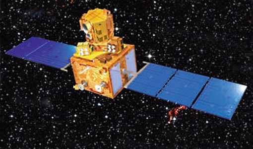
ResourceSat-2
EO
Imaging multi-spectral radiometers (vis/IR)
High resolution optical imagers
Land
The Indian Space Research Organisation (ISRO) launched ResourceSat-2 (IRS-R2), a data continuity mission with enhanced spectral bands over ResourceSat-1, from Satish Dhawan Space Centre (SHAR) in April 2011. ResourceSat-2 provides continuity for the environmental monitoring provided by ResourceSat-1, and boosts observation timeliness.
Quick facts
Overview
| Mission type | EO |
| Agency | ISRO |
| Mission status | Operational (extended) |
| Launch date | 20 Apr 2011 |
| Measurement domain | Land, Snow & Ice |
| Measurement category | Multi-purpose imagery (land), Vegetation, Albedo and reflectance, Landscape topography, Sea ice cover, edge and thickness, Snow cover, edge and depth |
| Measurement detailed | Land surface imagery, Vegetation type, Earth surface albedo, Land surface topography, Snow cover, Fraction of Absorbed PAR (FAPAR), Glacier cover |
| Instruments | LISS-III (Resourcesat), AWiFS, LISS-IV |
| Instrument type | Imaging multi-spectral radiometers (vis/IR), High resolution optical imagers |
| CEOS EO Handbook | See ResourceSat-2 summary |
Summary
Mission Capabilities
ResourceSat-2 carries three electro-optical cameras Advanced Wide Field Sensor (AWiFS), Linear Imaging Self-Scanning Sensor-3 (LISS-3), and Linear Imaging Self-Scanning Sensor-4 (LISS-4) as its payload, identical to the sensor complement of ResourceSat-1. The LISS-4 multispectral high-resolution camera is the prime instrument of this sensor complement, while LISS-3 is a medium-resolution multispectral camera that has the push broom instrument which is identical to LISS-3 on IRS-1C/1D.
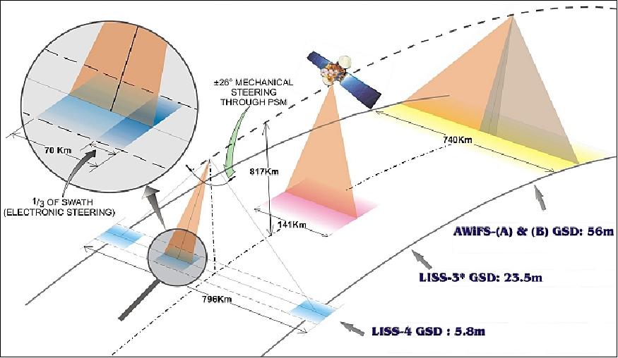
AWiFS is a wide-angle medium resolution (56 m) camera, with two AWiFS cameras, AWiFS-A and AWiFS-B.
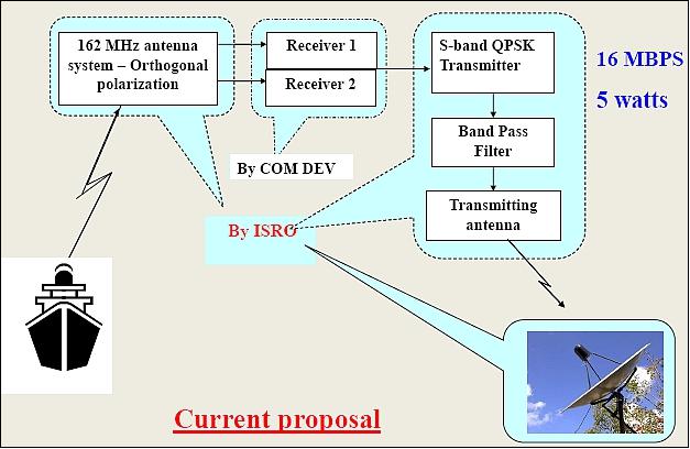
HIP-1 (Hosted Indian Payload) is an auxiliary Automatic Identification System (AIS) payload, designed by COMDEV, Canada. It is an additional payload carried by ResourceSat-2 with the objective to gather and transmit AIS signals from the ground segment to ground stations. This payload was an experimental payload for ship surveillance in the VHF band to derive the position, speed and other relevant information about ships.
ResourceSat-2 data is useful for applications such as urban planning, mapping, vegetation discrimination, land mapping, natural resources management and disaster management.
The mission's main goal is to improve spectral and geographical coverage of remote sensing data for integrated land and water resource management at the micro-level.
Performance Specifications
There are two AWiFS cameras, AWiFS-A and AWiFS-B, that provide a total swath width of 740 km. The data quantisation of all sensors has been improved to 10 bit as compared to ResourceSat-1 which had 7 bit provided to the data handling system. LISS-3 has three VNIR bands, each with a spatial resolution of 23.5 m and swath of 140 km. LISS-4 is a three-band pushbroom camera having the same spectral VNIR bands as LISS-3, but with a spatial resolution of 5.8 m and a swath of 70 km. All the payloads of ResourceSat-2 have radiometric improvements either by using DPCM (Delta Pulse Code Modulation) or MLG (Multi Linear Gain).
The satellite is in a sun-synchronous orbit, at an altitude of 817 km and an inclination of 98.78°. The LTDN (Local Time on Descending Node) is at 1030 hours, and the period is 101.35 minutes.
Space and Hardware Components
The Payload Data Handling System (PDHS) in ResourceSat-2 consists of Baseband Data Handling (BDH) and the X-band data transmission system. The BDH receives data from the sensors, formats it appropriately, adds auxiliary data, and transfers it to an X-band or Solid State Recorder (SSR) system for recording or downlink transmission. The onboard Solid State Recorder on ResourceSat-2 has a 400 GB capacity and is capable of capturing data globally as well as making data available to ground stations in real time.
The payload data are transmitted in X-band at a rate of 105 Mbit/s. All three imagers are multispectral pushbroom scanners with linear array Charge Coupled Devices (CCDs) as detectors.
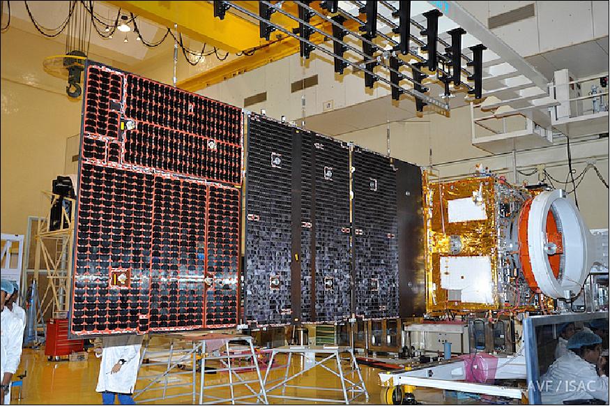
ResourceSat-2 and ResourceSat-2A satellites of ISRO
Spacecraft Launch Mission Status Sensor Complement References
ResourceSat-2 is a data continuity mission of ISRO (Indian Space Research Organization) with improved spectral bands of the IRS-P6/ResourceSat-1. Each ResourceSat satellite carries three electrooptical cameras as its payload: LISS-3, LISS-4 and AWiFS. All the three imagers are multispectral pushbroom scanners with linear array CCDs as detectors. The ResourceSat data find their application in several areas like agricultural crop discrimination and monitoring, crop acreage/yield estimation, precision farming, water resources, forest mapping, rural infrastructure development, disaster management etc. ResourceSat-2 provides continuity and increases the observation timeliness (repetivity) in tandem with ResourceSat-1. 1) 2) 3) 4) 5)
Spacecraft
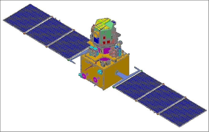
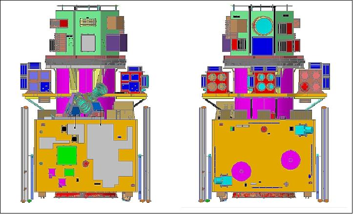
The S/C mainframe is of IRS-1C/1D -P3 heritage (built by ISRO/ISAC, Bangalore). The S/C structure consists of two modules, the main platform and the payload module. The main platform is built around a central load bearing cylinder of 915 mm diameter and consists of four vertical panels and two horizontal decks. The bottom of cylinder is attached to an interface ring which interfaces with the launch vehicle. The vertical panels and the horizontal decks carry the subsystem packages.
The spacecraft is 3-axis stabilized using reaction wheels, magnetic torquers and hydrazine thrusters. Attitude is sensed with star sensors, Earth sensors, and gyros. Various attitude sensors, SPS (Satellite Positioning System) and data transmitting antennas are mounted on the outside surfaces of the equipment panels and the bottom deck. Two star trackers are mounted with skewed orientation on the top deck. The payload module in turn is comprised of a two-tier system, the payload module deck and the rotating deck.
The payload module deck accommodates LISS-3, AWiFS-A and AWiFS-B camera modules. The LISS-4 camera is mounted on a rotating deck which is attached to a PSM (Payload Steering Motor) which can rotate by ± 26º to provide an event monitoring capability. The entire payload module assembly is attached to a CFRP monocoque cylinder, which in turn is attached to the main cylinder of the main platform through a strut assembly for effective load transfer.
The overall S/C size is about 2 m in diameter and 2.1 m in height. The total S/C mass at launch is ~1200 kg, including fuel for five years of operation. Power is provided by a solar array generating 1250 W (EOL), the array is articulated into the sun; in addition there are 2 NiCD batteries with a capacity of 24 Ah each. The platform is three-axis stabilized [2 star sensors in loop, magnetic bearing reaction wheels, RCS (Reaction Control System) with 12 nozzles, 8 with 1 N thrusters, 4 nozzles with 11 N thrusters], the pointing accuracies are ±0.15º, the stability is 3 x 10⁻⁴ º/s. An onboard solid-state recorder (SSR) provides 400 Gbit capacity to store about 60 minutes of LISS-4 data. The S/C design life is 5 years.
RF communications: TT&C communications in S-band with downlink data rates of 1-16 kbit/s; modulation: PCM/PSK/PM. The uplink data rate is 100 bit/s. The TT&C transponder transmits the telemetry data, receives the telecommand signals, demodulate the ranging tones and re-transmits them to ground with a fixed turnaround ratio of 240/221 for two-way ranging (Doppler measurement). Uplink frequency: 2071.875 MHz, downlink frequency: 2250 MHz.
The payload data are transmitted in X-band at a data rate of 105 Mbit/s. The BDH (Baseband Data Handling) system consists of two separate chains, one for LISS-3 and AWiFS data, and the second chain for LISS-4 data. The LISS-4 data are transmitted on carrier-1 at 8125 MHz and LISS-3 + AWiFS data are transmitted on carrier-2 at 8300 MHz.
Mainframe system | - Al and Al honeycomb structure with CFRP elements for main platform and payload modules |
Thermal control | Passive, semi-active and active elements like OSR (Optical Solar Reflectors), MLI (Multi-Layer Insulation), heat pipes, tape/foil heaters etc,. |
Power system |
|
AOCS |
|
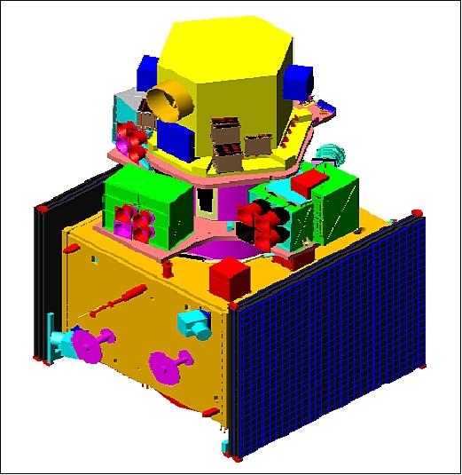
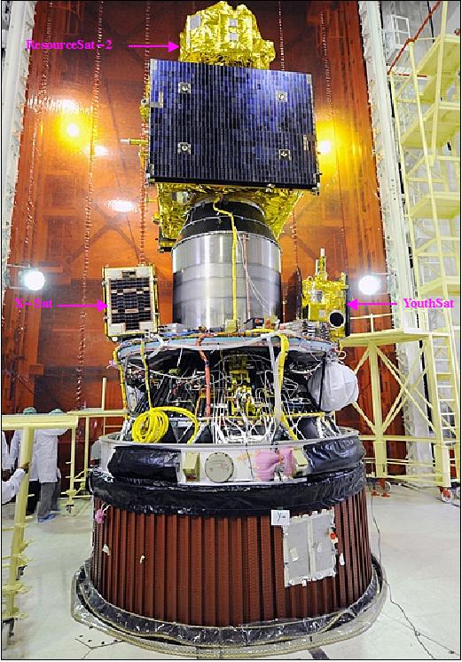
Figure 4: Photo of the PSLV-16 integrated payloads of ResourceSat-2, X-Sat and YouthSat (image credit: ISRO) 6)
Launch
ResourceSat-2 was launched on April 20, 2011 on the PSLV-C16 launcher from SHAR (Satish Dhawan Space Centre, Sriharikota), India. The secondary payloads on this mission are: 7) 8)
• XSAT of NTU, Singapore
• YouthSat of ISRO and Roskosmos
Orbit: Sun-synchronous orbit, altitude = 817 km, inclination = 98.78º, period = 101.35 minutes, local time of equator crossing at 10:30 AM on descending node. The ground track is maintained within ± 1 km, repeat cycle of 24 days. A phasing of 180º is realized with regard to the ResourceSat-1 satellite. 9)
The ResourceSat-2A spacecraft was launched on December 7, 2016 on the PSLV-C36 launch vehicle (XL version) of ISRO from SDSC (Satish Dhawan Space Center), India. The spacecraft has a launch mass of 1235 kg. 10) 11)
Note: ResourceSat-2A is a follow on mission to ResourceSat-2 and intended to provide data continuity to the users. Each ResourceSat satellite carries three electrooptical cameras as its payload: LISS-3, LISS-4 and AWiFS. All the three imagers are multispectral pushbroom scanners with linear array CCDs as detectors.
Orbit: Sun-synchronous orbit, altitude = 817 km, inclination = 98.78º, period = 101.35 minutes, local time of equator crossing at 10:30 AM on descending node.
Secondary payloads: It was also decided that the ResourceSat-2Aspacecraft will be the only passenger of the PSLV-C36 mission. Earlier plans envisioned several other smaller payloads that could piggyback on the mission; however, their flight was postponed to 2017.
ISRO originally had planned to launch two additional Indian satellites: the IITMSAT, designed for ionospheric research, and an Earth-observing spacecraft named NIUSAT. The Italian Max Valier Sat nanosatellite for X-ray astronomy research and a Latvian nanosatellite Venta-1 built for ship tracking purposes were also on the list of optional payloads. 12)
Mission Status
• January 1, 2018: Resourcesat-2A was launched in December 2016. It carries high-resolution LISS-4 sensor with 5.8 m spatial resolution and a five-day revisit capability; medium resolution LISS-3 sensor with 23.5 m spatial resolution and a coarse resolution AWiFS sensor with 56 m spatial resolution. All three payloads AWiFS, LISS-III and LISS-IV sensors are operated to acquire multi-resolution data over India and surroundings. Resourcesat-2A has been added to the fleet of Resourcesat series of satellites in order to deliver high quality images to generate consistent data products. 13)
- With Resourcesat-2 and Resourcesat-2A together in orbit, the revisit capability has improved to 2-3 days for AWiFS, 12-13 days for LISS-3 and 25-26 days for LISS-4. Combined revisits of Resourcesat-2 and 2A along with other satellites are useful in many ways for various applications.
- Resourcesat-2A data products, namely, radiometrically corrected system level products, Geo referenced terrain corrected and Ortho-rectified products were released for the user community from May 06, 2017 onwards after all the mission tests and calibration/ validation.
- Resourcesat-2A provides continuity of data with higher temporal resolution (therefore more cloud-free data) for various operational applications, namely, crop production estimation, forest cover mapping, mapping and monitoring land and water resources, environmental applications, rural and urban development plans, geological applications, disaster management support etc. The typical advantage of improved revisit as a consequence of Resourcesat-2 and -2A constellation is extremely useful for monitoring vegetation and water resources.
- The inputs for operational programs, such as, Crop Monitoring, Horticultural crops assessment and development, Periodic water spread maps, Watershed Development projected care ensured with improved temporal resolution. New initiatives, such as, crop insurance, multi crop inventory and near real time disaster management support etc are ably supported.
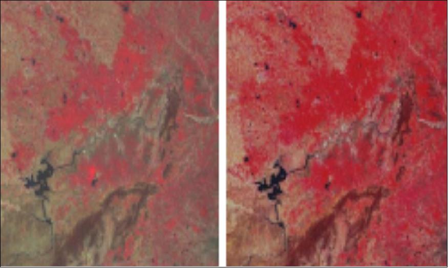
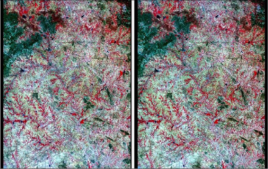
- The growth of a typical annual crop (120 days) during the kharif season can now be captured in 10 scenes instead of 4 to 5 scenes, thus improving the chances of getting cloud free data as well as improving accuracy of estimation of area and productivity models. This helps in better selection of the bio-window for vegetation studies. Figures 6 and 7 illustrate the advantages of improved revisit of Resourcesat-2 & -2A as a constellation.
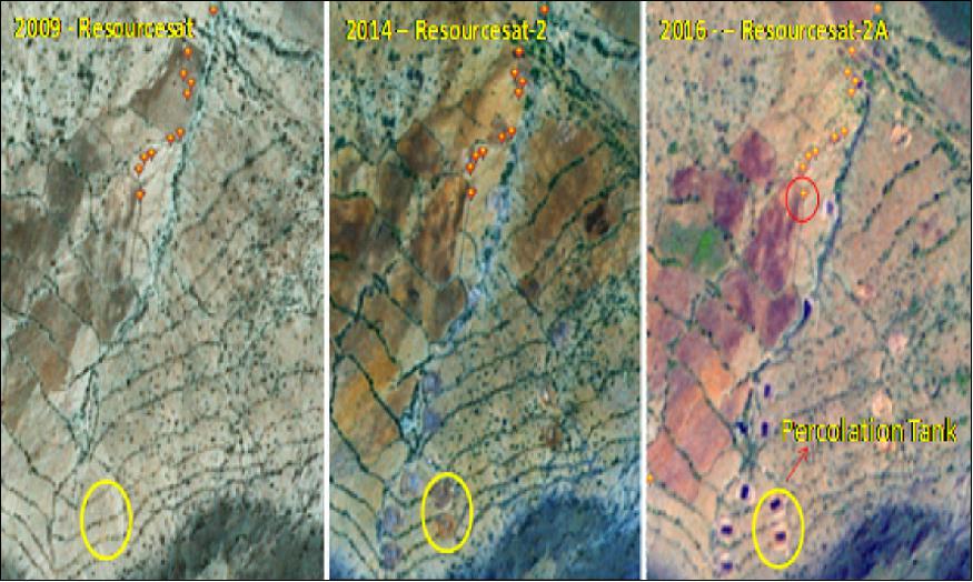
- With respect to rural regions, the monitoring of IWMP (Integrated Watershed Management Program) could be done more frequently than before as LISS-IV data along with Cartosat-1 data are used to monitor the changes in IWMP watersheds. About 8,200 such projects are to be monitored over a period of 5 years. About 2,000 LISS-IV products are needed annually for the study. 8,200 projects are being monitored in the country and 2,500 scenes of Resourcesat-2 & 2A are being procured every year for the study. An example for the monitoring of the microwatershed in Prakasam District of Andhra Pradesh is shown in Figure 8.
- The improved availability of Resourcesat-2 & -2A data is useful for disaster monitoring, especially for events like flood mapping and monitoring at village level and damage assessment.
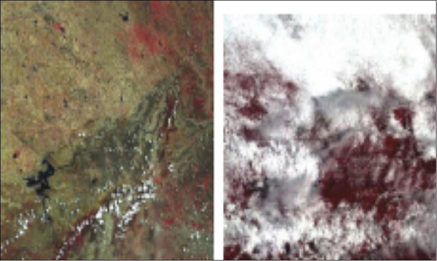
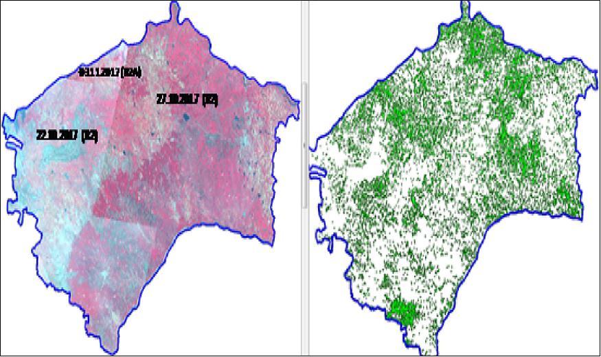
- The specific advantage of having constellation of Resourcesat-2 & -2A is shown in the Figure 9. The figure shows the image generated by combining the data from Resourcesat-2 & -2A and right image shows classified cotton crop of Raichur district, Karnataka. The data of top left corner was generated from Resourcesat-2A (03/11/2017) and of the same path as Resourcesat-2. The figure indicates that if Resourcesat-2A was not there, we would have missed the top left part of the data and next possibility was on 15/11/2017 (Resourcesat-2) and by then cotton crop would have senesced or harvested. This would have led to uncertainties in estimation.
• July 2016: Resourcesat-2 has successfully completed five years of operations in its orbit. This satellite has multi-resolution and multi-spectral capabilities in a single platform. A continuous and autonomous co-registration, geo-location and radiometric calibration of image data from different sensors with widely varying view angles and resolution was one of the challenges of ResourceSat-2 data processing. The project team has widely assessed and calibrated the on-orbit geometric performance of ResourceSat-2 sensors during the initial phase operations. 14)
- Since then, as an ongoing activity, various geometric performance data are being generated periodically. This is performed with sites of dense GCPs (Ground Control Points). These parameters are correlated to the direct geo-location accuracy of the ResourceSat-2 sensors and are monitored and validated to maintain the performance. This is done using a viewing geometry model, given ephemeris and attitude data, precise camera geometry and datum transformation. In the model, the forward and reverse transformations between the coordinate systems associated with the focal plane, payload, body, orbit and ground are rigorously and explicitly defined. System level tests using comparisons to ground check points have validated the operational geo-location accuracy performance and the stability of the calibration parameters.
• ResourceSat-2 and its payload are operating nominally in 2016.
• ResourceSat-2 and its payload are operating nominally in 2015. 15)
• December 2014: The ResourceSat-2 mission provides continuity of remote sensing data for various national and international projects. The core objective of this mission is to support remote sensing data for integrated land and water resources management at micro level, with improved spectral and spatial coverage. This data also supports many projects in diversified fields of applications like agricultural crop discrimination and monitoring, crop acreage / yield estimation, precision farming, water resources, forest mapping, infrastructure development, disaster management, snow and glacier studies, coastal zone management, urban landscape, locating groundwater potential zones etc,. ResourceSat-2 has the capability to capture the data globally through the onboard Solid State Recorder having 400 GB capacity apart from making the data available to the ground stations in realtime.
- An ISRO team examined the potential of using LISS-3 (Linear Imaging Self Scanning Sensor-3)images of ResourceSat-2 in the absence of Landsat-8 OLI (Operational Land Imager) images. The LISS-3 images were selected for comparison because of their close resemblance in the electromagnetic spectrum range with LS-8 OLI images. 16)
OLI (Operational Land Imager) of Landsat-8 | LISS-3 (Linear Imaging Self Scanning sensor-3) of ResourceSat-2 | ||||
Bands | Wavelength (µm) | Resolution (m) | Bands | Wavelength (µm) | Resolution (m) |
B1 - Coastal aerosol | 0.43-045 | 30 | - | - | - |
B2 - Blue | 0.45-0.51 | 30 | - | - | - |
B3 - Green | 0.53-0.59 | 30 | B2 - Green | 0.52 - 0.59 | 24 |
B4 - Red | 0.64-0.67 | 30 | B3 - Red | 0.62 - 0.68 | 24 |
Band 5 NIR (Near Infrared) | 0.85-0.88 | 30 | B4 - NIR | 0.77 - 0.86 | 24 |
B6 - SWIR1 | 1.57-1.65 | 30 | B5 - SWIR | 1.55 - 1.70 | 24 |
B7 - SWIR2 | 2.11-2.29 | 30 | - | - | - |
B9 - Cirrus | 1.36-1.38 | 30 | - | - | - |
Parameter | ResourceSat-2 LISS-3 | Landsat-8 OLI |
Path-Row | 99-60, 61 | 144-48 |
Date of Pass | 15-04-2013 | 13-04-2013 |
Scene center time (hh:mm:ss) | 05:33:07.643809 (row-60) | 05:11:28.479429 |
Sun elevation /azimuth angles | 69.97 / 111.21 | 65.62 / 106.11 |
Bands | 2345 | 3456 |
Resampling | Cubic convolution | Cubic convolution |
Projection/Datum | UTM / WGS84 | UTM / WGS84 |
Correction level | Terrain corrected | Ortho corrected |
Output resolution | 24 m | 30 m |
- In summary, the LISS-3 and OLI sensors are very similar in various aspects including image quality, spectral band width though there are some basic differences like spatial resolution. Similar band ranges and high resolution images of LISS-3 could make a better substitute for Landsat-8 images. In terms of spectral similarity, intra band correlations of OLI and LISS-3 images show higher than 90%. Inter band correlation coefficient between RS-2 and Landsat-8 images show higher than 60% except for band-4 (Ref. 16).
• In July 2014, India and Brazil signed an agreement which would facilitate the Brazilian earth stations to receive and process data from Indian Remote Sensing satellites (IRS). Confirming the news, a statement issued by the Prime Minister's Office (PMO) read, "The agreement provides for the reception of data from AWiFS and LISS-III payloads of IRS satellites, including but not limited to the ResourceSat-2 at Cuiaba Earth station in Brazil on a government-to-government cooperation basis." 17)
- The agreement mandates the Brazilian Space Agency (AEB) to designate the National Institute for Space (INPE), the Brazilian executive agency for the subject of Earth observation data reception, processing, archiving, and distribution to take responsibility and to work together with ISRO and its executive agency (National Remote Sensing Center) to accomplish the actions put down.
- ISRO will provide remotely sensed data of areas within the acquisition radius of INPE's Earth station in Cuiaba acquired by AWiFS and LISS-III payloads of IRS satellites to INPE. The agreement also requires ISRO to provide INPE with the specific hardware required to augment the Cuiabá Earth station and facilitate the reception of IRS satellite data, including the ResourceSat-2 AWiFS and LISS-III. ISRO will also provide the front-end hardware and software upgrades required to process and generate products from the IRS satellite data it receives. And finally, ISRO's responsibility also entails providing the necessary training to INPE's technical staff on IRS satellite data reception and processing, including for ResourceSat-2.
• ResourceSat-2 and its payload are operating nominally in 2013.
- On May 7, 2013, ResourceSat-2 acquired flood waters in the Wasit Governorate of eastern Iraq. 18)
• An international team (USGS, ISRO, Science Systems and Applications Inc., Sigma Space Corporation) and NASA) performed a ResourceSat-2 data quality assessment by comparing near-simultaneous surface observations based on image statistics between RS-2 (ResourceSat-2) AWiFS and Terra and Aqua MODIS sensors. 19)
RS-2 AWiFS geometry assessment:
- Completed using the IAS (Image Assessment System) which was developed for radiometric and geometric characterization and calibration for the Landsat program.20)
- The RS-2 AWiFS data acquired over Sioux Falls, SD and Pueblo, CO were used for this study (a total of 4 AWiFS images over Sioux Falls and 2 images over Pueblo were used in this study).
- The positional accuracy was assessed by using the I2I registration assessment tool by comparing the RS-2 AWiFS imagery against the GLS-2005 (Global Land Surface-2005) dataset as a reference image (a total of 44 GLS images over Sioux Falls, SD Valley, and 17 images over Pueblo, CO were mosaicked and used as a reference).
Geometry assessment summary:
- RS-2 AWiFS preliminary analysis show discrepancies compared to the reference GLS dataset (this was confirmed by IAS and visual inspection)
- The RS-2 AWiFS data obtained from ISRO did not include GCP corrections to improve geometric quality, so we are working closely with ISRO to reevaluate the positional accuracy of RS-2 AWiFS data acquired outside India (Ref. 19).
• ResourceSat-2 and its payload are operating nominally in 2012. 21) 22)
• The ResourceSat-2 commissioning phase ended in late June 2011. On July 1, 2011, the mission became operational. 23)
• The first images of ResourceSat-2 were acquired on April 28, 2011 by ISRO.
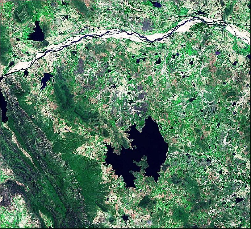
Legend to Figure 12: The Krishna River (upper part of the image) is one of the longest rivers in central-southern India, about 1,300 km in length. It flows from west to east and empties in the Bay of Bengal in the state of Andhra Pradesh on the east coast of India. Ecologically, this is one of the most dangerous rivers in the world, in that it causes heavy flooding and soil erosion during the monsoon season.
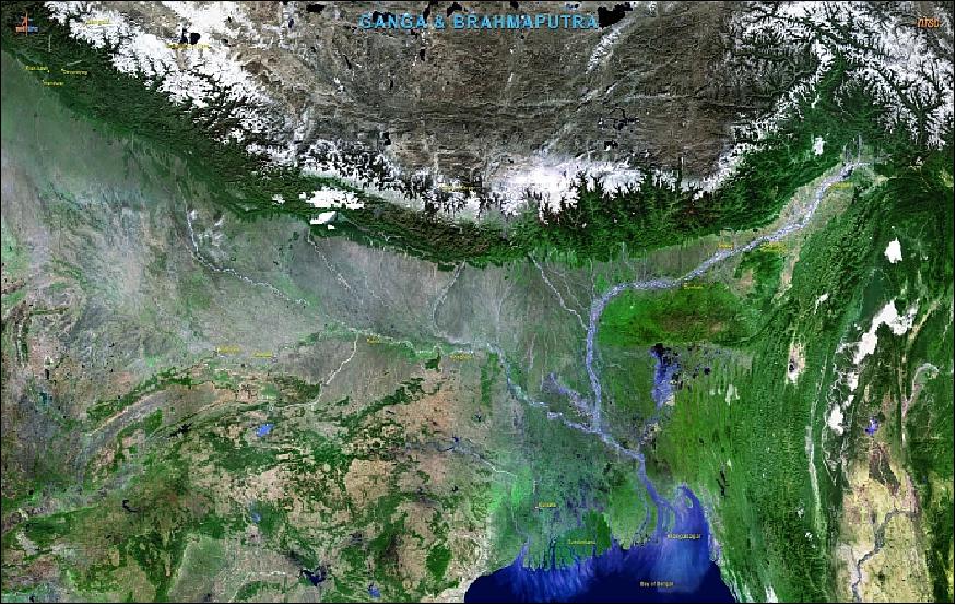
Legend to Figure 13: The Ganges-Bramaputra river delta is the world's largest delta, and empties into the Bay of Bengal. It is also one of the most fertile regions in the world, thus earning the nickname The Green Delta. It covers more than 105,000 km2. Between 125 and 143 million people live on the delta, despite risks from floods caused by monsoons, heavy runoff from the melting snows of the Himalayas, and tropical cyclones. A large part of the nation of Bangladesh lies in the Ganges Delta, and many of the country's people depend on the delta for survival. The total river basin covers an area of 1.7 million km2, distributed between India (64%), China (18%), Nepal (9%), Bangladesh (7%) and Bhutan (3%).
• Immediately after the injection of the satellite, the two solar panels were deployed. The three Imaging Cameras have been oriented towards Earth. All operations and health checks required prior to switching on the three Imaging Cameras have been satisfactorily completed (Ref. 7). 24)
- An orbital trimming maneuver was conducted successfully on April 22, 2011, and ResourceSat-2 is now placed in the final orbital configuration in a sun-synchronous polar orbit with perigee of 813 km; apogee of 825 km and inclination of 98.78º.
Sensor Complement
The sensor complement is identical to that of the ResourceSat-1 mission. There are two AWiFS cameras, AWiFS-A and AWiFS-B, providing a combined swath width of 740 km. The data quantization of all sensors has been improved to 10 bit. In addition, the MS swath of LISS-4 has been increased to 70 km (from 23.9 km on ResourceSat-1). Radiometric improvements have been carried out in all the payloads of ResourceSat-2 using either DPCM (Delta Pulse Code Modulation) or MLG (Multi Linear Gain). 25) 26) 27)
All the three cameras are observing in the ‘pushbroom scanning' concept using linear arrays of CCDs (Charge Coupled Devices). In this mode of operation, each line of image is electronically scanned and contiguous lines are imaged by the forward motion of the satellite.
Parameter/Instrument | LISS-4 | LISS-3 | AWiFS |
Spatial resolution or IFOV (Instantaneous Field of View) | ≤ 5.8 m | 23.5 m | 56 m (nadir) |
Spectral bands (µm) | B2: 0.52-0.59, (green) | B2: 0.52-0.59, (green) | B2: 0.52-0.59, (green) |
Swath width | 70 km in PAN and MS mode | 141 km | 740 km |
Detector line arrays x No of elements | 1 x 12,288 PAN mode | 4 x 6,000 | 4 x 2 x 6,000 |
Data quantization | 10 bit | 10 bit (VNIR), | 10 bit |
Square wave response at Nyquist | > 20 | B2> 0.40, B3> 0.40 | B2> 0.40, B3> 0.40 |
Power consumption | 216 W | 70 W | 114 W |
Instrument mass | 169.5 kg | 106.1 kg | 103.6 kg |
Date rate | 105 Mbit/s | 52.5 Mbit/s | 52.5 Mbit/s |
LISS-4 (Linear Imaging Self-Scanning Sensor-4)
The LISS-4 multispectral high-resolution camera is the prime instrument of this sensor complement. LISS-4 is a three-band pushbroom camera of LISS-3 heritage (same spectral VNIR bands as LISS-3) with a spatial resolution of 5.8 m and a swath of 70 km. LISS-4 can be operated in either of two support modes: 28) 29)
• Multispectral (MS) mode: Data is collected in 3 bands corresponding to pre-selected 4096 contiguous pixels with a swath width of 23.9 km (selectable out of 70 km total swath). Note: the new swath width of LISS-4 is 70 km for band 3 - but in mono mode only.
• Mono mode: Data of the full 12 k pixels of any one single selected band, corresponding to a swath of 70 km, can be transmitted. Nominally, band-3 data (B3) are being observed and transmitted in this mode.
LISS-4 features in addition a ±26º steering capability in the cross-track direction permitting a 5-day revisit cycle. The optoelectronic module of LISS-4 is identical to that of the PAN camera of IRS-1C/1D. The CCD array features 12,288 elements for each band. The instrument has a mass of 169.5 kg, power of 216 W, and a data rate of 105 Mbit/s. The detector temperature control is implemented using a radiator plate coupled to each band CCD through heat pipes and copper braid strips.
The LISS-4 camera is realized using the three mirror reflective telescope optics (same as that of the PAN camera of IRS-1C/1D) and 12,288 pixels linear array CCDs with each pixel of the size 7 µm x 7 µm. Three such CCDs are placed in the focal plane of the telescope along with their individual spectral bandpass filters. An optical arrangement comprising an isosceles prism is employed to split the beam into three imaging fields which are separated in the along track direction. The projection of this separation on ground translates into a distance of 14.2 km between the B2 and B4 image lines. While B3 is looking at nadir, B2 is looking ahead and B4 is looking behind in the direction of velocity vector. Detector type: THX31543A of Thomson.
LISS-4 calibration: An in-flight calibration scheme is implemented using LEDs (Light Emitting Diodes). Eight LEDs positioned in front of the CCD (without obstructing the light path during imaging). These LEDs are driven with a constant current and the integration time is varied to get 16 exposure levels, covering the dynamic range in a sequential manner. This sequence repeats in a cyclic form.
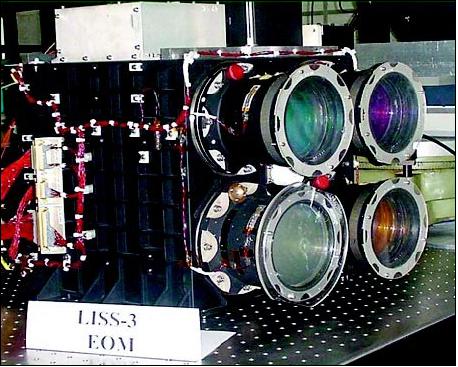
LISS-3 (Linear Imaging Self-Scanning Sensor-3)
LISS-3 is a medium-resolution multispectral camera. The pushbroom instrument is identical to LISS-3 on IRS-1C/1D (with regard to lens modules, detectors, and electronics) in the three VNIR bands, each with a spatial resolution of 23.5 m. The resolution of the SWIR band is now also of 23.5 m on a swath of 140 km. The optics design and the detector of the SWIR band are modified to suit the required resolution; B5 uses a 6,000 element Indium Gallium Arsenide CCD with a pixel size of 13 µm. The SWIR CCD is a new device employing a CMOS readout technique for each pixel, thereby improving noise performance. The VNIR CCD array features 6,000 elements for each band. The instrument has a mass of 106.1 kg, a power consumption of 70 W, and a data rate of 52.5 Mbit/s.
The in-flight calibration of the LISS-3 camera is carried out using 4 LEDs per CCD in the VNIR bands and 6 LEDs for the SWIR band. These LEDs are operated in pulsed mode and the pulse duration during which these LEDs are ON is varied in specific steps. Each LED has a cylindrical lens to distribute the light intensity onto the CCD. Each calibration cycle consists of 2048 lines providing six non zero intensity levels.
AWiFS (Advanced Wide Field Sensor)
AWiFS is a wide-angle medium resolution (56 m) camera with a swath of 740 km (FOV=±25º) of WiFS heritage. The pushbroom instrument operates in three spectral bands which are identical to two VNIR bands (0.62 - 0.68 µm, 0.77 - 0.86 µm) and the SWIR band (1.55-1.70 µm) of the LISS-3 camera. The AWiFS camera is realized using two separate optoelectronic modules which are tilted by 11.94º with respect to nadir. Each module covers a swath of 370 km providing a combined swath of 740 km with a side lap between them. The wide swath coverage enables AWiFS to provide a five-day repeat capability. The optoelectronic modules contain refractive imaging optics along with band pass interference filter, a neutral density filter and a 6000 pixels linear array CCD detector for each spectral band.
The in-flight calibration is implemented using 6 LEDs in front of each CCD. For the VNIR bands (B2, B3, B4), the calibration is a progressively increasing sequence of 16 intensity levels through exposure control. For the SWIR band, the calibration sequence is similar to that of LISS-3 through a repetitive cycle of 2048 scan lines.

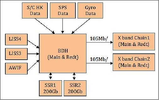
PDHS (Payload Data Handling System)
The PDHS receives the digital data from each camera in bit parallel - byte serial mode, formats it with auxiliary data, modulates it on the RF carrier and transmits to the ground. Like ResourceSat-1 spacecraft, ResourceSat-2 also has two separate downlink chains in X-band, both operating at 105 Mbit/s data rate. Unlike ResourceSat-1, where each chain was dedicated to LISS-4 and LISS-3/AWiFS, in ResourceSat-2, there exists flexibility of downlinking payload data through any one of the chains. The PDHS of the ResourceSat-2 spacecraft essentially consists of two subsystems – BDH (Baseband Data Handling) and the X-band data transmission system (Ref. 26).
BDH subsystem: The BDH receives LISS-3, LISS-4 and AWIFS payload data, formats them suitably along with auxiliary information and send the data to X-band or SSR system for downlink transmission or recording, respectively.
BDH for LISS-4 camera: The LISS-4 camera features three bands B2, B3, B4, the output is encoded according to DPCM (Differentially Pulse Code Modulation). DPCM encodes ten bit pixel information into seven bits. BDH for the LISS -3 formatter receives seven bit DPCM encoded data, multiplexes the different band data, and formats them into frames along with auxiliary information.
The frame data is RS (Reed Solomon) encoded, randomized, and differentially encoded for transmission. There are different modes by which the LISS-4 data may be downloaded. Like its predecessor ResourceSat-1, there exists downloading of data either in mono or 23 km Mx mode. Mono mode provides 70 km of swath and any one of the band may be selected for download. In the 23 km Mx mode, all three bands for a swath 23 km from a selected position in 70 km may be downloaded. An additional 70 km Mx mode exists in ResourceSat-2, when compared to ResourceSat-1. In this mode one of the band data is transmitted in real-time and other two are recorded for later down-loading through both chains of RF. In case of ground station non-visibility, all the three bands may be recorded and played back according to station availability.
HIP-1 (Hosted Indian Payload)
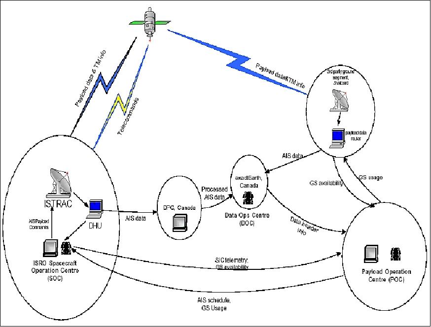
HIP-1 is an (auxiliary) AIS (Automatic Identification System) payload of COM DEV International Ltd., Cambridge, Ontario, Canada. The objective is to collect AIS signals from the ground segment and to transmit the information to ground stations. 30) 31)
• HIP-1 is a payload of Resource Sat-2 (ISRO)
• Two polarizations / 4 channels
• S-band data downlink (frequency: 2.280 MHz, output power = 5 W, modulation = QPSK, data rate = 16 Mbit/s).
A MoA (Memorandum of Agreement) has been signed between Antrix/ISRO and COM DEV Canada according to the following terms:
- An AIS payload of COM DEV will be a hosted payload on-board the ResourceSat-2 spacecraft
- COM DEV will supply the VHF receiver & data processing S/W – ISRO will supply the S-band transmitter,VHF antennas, an S-band antenna and a filter
- COM DEV will supply to ISRO AIS data of all ships over Indian waters & all Indian flag ships over Global seas for usage by Indian users
- The AIS data will be received by ISRO ground station (ISTRAC) & COM DEV G/S (Svalbard). COM DEV will install processing S/W at ISRO G/S to process the data and send it to COM DEV, Canada
- ISTRAC will disseminate the AIS data and make it available to various Indian users.
AIS payload:
• Operating in the VHF maritime band (160 -162 MHz)
- standardized digital communication protocols
- each station transmits and receives over two radio channels to avoid interference problems
• Transmissions use 9.6 kbit/s with GMSK/FM modulation
• Uses SOTDMA (Self-Organizing Time Division Multiple Access) technology to meet this high broadcast rate and ensure reliable ship-to-ship operation
- Each station determines its own transmission schedule (slot), based upon data link traffic history and knowledge of future actions by other stations.
AIS Payload Operations
• Payload operations are independent of ResourceSat-2 hosted payload operations
• Payload operated as per COM DEV requirement
• Data processing locally and sent to DOC (Data Operation Center), Canada
• Data is to be acquired in 39 minutes per orbit (40 %) or 100% based on requirement
• 10 segments / orbit. (1 acquisition unit = 99 seconds)
• Data acquisition over pre-determined segments of an orbit uplinked as acquisition profile
• Acquisition profile to be uplinked for every orbit
• Receivers will be switched on/off based on the profile command (1/0)
• Profile holds good till another profile is uplinked
• Data to be downloaded over 2/3 stations: Svalbard, Bangalore (ISTRAC), TBD
• Download over stations by issuing S-band on & off command from the receiver.
Applicable standard | MSC.74(69) Annex 3, IEC 61993-2 (Draft), ITU-R M.1371-1 |
Radio frequencies | AIS1: 161.975 MHz |
Channel spacing | 12.5 kHz/25 kHz |
Output power | 12.5 W/2W |
Modulation | GMSK (Gaussian Minimum Shift Keying) |
Bit rate | 9600 bit/s ±30 ppm |
Synchronization | SOTDMA, (UTC Indirect, Synchronization to base station) |
Time slot | 2250 slots/min (1 slot = 256 bit) |
Frequency | 2.280 GHz |
Output power | 5 W |
Modulation | QPSK (Quadra-Phase Shift Keying) |
Data rate | 16 Mbit/s |
References
1) Marappa Krishnaswamy, "Future Remote Sensing Missions of ISRO," Proceedings of the 59th IAC (International Astronautical Congress), Glasgow, Scotland, UK, Sept. 29 to Oct. 3, 2008, IAC-08.B1.1.6
2) M. Venkata Rao, J. P. Gupta, Ram Rattan, K. Thyagarajan, "ResourceSat-2: a mission for Earth resources management," Proceedings of SPIE, 'GEOSS and Next-Generation Sensors and Missions,' Vol. 6407, Panaji, Goa, India, Nov. 13-17, 2006, DOI:10.1117/12.697973,
3) Virender Kumar, "Indian Remote Sensing Satellites - Current and Future Missions," PECAD 2007 (Production Estimates and Crop Assessment Division), July 16, 2007, URL: http://www.pecad.fas.usda.gov/pdfs/2007/1%20Virender%20Kumar.pdf
4) Timothy J. Puckorius, "Indian Remote Sensing Satellites - Current & Future ResourceSat Missions," Proceedings of JACIE 2007 (Joint Agency Civil Commercial Imagery Evaluation Workshop, March 2007, URL: http://calval.cr.usgs.gov/JACIE_files/JACIE07/Files/111Pucko.pdf
5) Deviprasad Karnik, "ResourceSat-2 Mission Status," JACIE (Joint Agency Commercial Imagery Evaluation Workshop, Fairfax, VA, USA, March 16-18, 2010, URL: http://calval.cr.usgs.gov/JACIE_files/JACIE10
/Presentations/WedAM/Karnik_Deviprasad_JACIE2010FINAL.pdf
6) http://www.isro.org/pslv-c16/Imagegallery/satellite.aspx
7) "PSLV-C16 Flight Successful: RESOURCESAT-2, YOUTHSAT and X-SAT Satellites Functioning Satisfactorily," ISRO Press Release, April 25, 2011, URL: http://www.isro.org/pressrelease/scripts/pressreleasein.aspx?Apr25_2011
8) http://www.indianspacestation.com/iss/35-articles
/242-pslv-c16-resourcesat-2-launch-on-april-20-2011.html
9) Brochure of PSLC-16, ISRO, URL: http://www.isro.org/pslv-c16/pdf/PSLV-C16Brochure.pdf#RESOURCESAT
10) "PSLV-C36 Successfully Launches RESOURCESAT-2A Remote Sensing Satellite," ISRO, Dec. 07, 2016, URL: http://www.isro.gov.in/update/07-dec-2016/pslv
-c36-successfully-launches-resourcesat-2a-remote-sensing-satellite
11) "PSLV-C36 / ResourceSat-2A," ISRO, Nov. 30, 2016, URL: http://www.isro.gov.in/launcher/pslv-c36-resourcesat-2a
12) Tomasz Nowakowski, "India's newest remote sensing satellite launches atop PSLV booster," Spaceflight Insider, Dec. 7, 2016, URL: http://www.spaceflightinsider.com/organizations/isro
/india-newest-remote-sensing-satellite-launches-atop-pslv-booster/
13) "Resourcesat-2A Completes One Year in Space," ISRO, 01 Jan. 2018, URL: https://web.archive.org/web/20190227222947/https://www.isro.gov.in/resourcesat-2a-completes-one-year-space
14) P .V .Radhadevi, S. S. Solanki, A. Akilan, M. V. Jyothi, V. Nagasubramanian, "Performance assessment and geometric calibration of ResourceSat-2," Proceedings of the XXIII ISPRS ((International Society for Photogrammetry and Remote Sensing) Congress, Prague, Czech Republic, July 12-19, 2016, doi:10.5194/isprsarchives-XLI-B1-237-2016, URL: http://www.int-arch-photogramm-remote-sens-spatial-
inf-sci.net/XLI-B1/237/2016/isprs-archives-XLI-B1-237-2016.pdf
15) Vinay K Dadhwal, "Indian Space Program - Update on activities (Feb 2015)," 52nd Science & Technology Sub-Committee, UNCOPUOS, 3 Feb 2015, Vienna, Austria, URL: http://www.unoosa.org/pdf/pres/stsc2015/tech-02E.pdf
16) E. Venkateswarlu, T. Sivannarayana, K. V. Ratna Kumar, "A comparative analysis of ResourceSat-2 LISS-3 and Landsat-8 OLI imagery," The International Archives of the Photogrammetry, Remote Sensing and Spatial Information Sciences, Volume XL-8, 2014, ISPRS Technical Commission VIII Symposium, 09 – 12 December 2014, Hyderabad, India, URL: http://www.int-arch-photogramm-remote-sens-
spatial-inf-sci.net/XL-8/987/2014/isprsarchives-XL-8-987-2014.pdf
17) "India, Brazil sign agreement on IRS satellite data," Geospatial World, July 17, 2014, URL: http://geospatialworld.net/News/View.aspx?id=29441_Article
18) "Food Waters over Wasit Governorate, Republic of Irak,"UNITAR/UNOSAT, May 9, 2013, URL: http://unosat-maps.web.cern.ch/unosat-maps/IQ
/FL20130508IRQ/UNOSAT_FL20130308IRQ_WasitFlood_20130309_v2.pdf
19) Gyanesh Chander, Amit Angal, Aparajithan Sampath, A. Senthil Kumar, Taeyoung (Jason) Choi, Xiaoxiong (Jack) Xiong, Greg Stensaas, "ResourceSat-2 AWiFS Preliminary Data Quality Assessment," 12th Annual JACIE (Joint Agency Commercial Imagery Evaluation) Workshop , St. Louis, MO, USA, April 16-18, 2013, URL: https://calval.cr.usgs.gov/wordpress
/wp-content/uploads/2013_04_Chander_R2AWiFS_JACIE.pdf
20) "PSLV-C16 Successfully Launches RESOURCESAT-2, YOUTHSAT and X-SAT Satellites," ISRO Newsletter, April-December 2011, URL: http://www.isro.gov.in/newsletters/contents/spaceindia/apr2011-dec2011/article1.htm
21) M.Venkata Rao, "Present and Future Earth Observation (EO) Satellites," User Interaction Meeting, NRSC (National Remote Sensing Center), Hyderabad, India, Feb. 16-17, 2012, URL: http://www.nrsc.gov.in/assets/pdf/vr.pdf
22) D. Gowrisankar, ISRO delegation, "Recent Applications of ResourceSat-2," Proceedings of the 49th Session of UNCOPUOS-STSC (UN Committee on the Peaceful Uses of Outer Space-Scientific and Technical Subcommittee), Vienna, Austria, Feb. 6-17, 2012, URL: http://www.oosa.unvienna.org/pdf/pres/stsc2012/tech-45E.pdf
23) Information provided by Rajeev Kumar Jaiswal of ISRO/HQ, EOS/NNRMS Programme Office, Bangalore, India
24) Space India, Newsletter, ISRO, April-December 2011, URL: http://www.isro.gov.in/newsletters/contents
/spaceindia/apr2011-dec2011/apr2011-dec2011.pdf
25) V. S. Hedge, "ResourceSat-2: Continuing global services in Earth Observation," 54th UN-COPOUS (United Nations Committee on the Peaceful Uses of Outer Space), Vienna, Austria, June 1-10, 2011, URL: http://www.oosa.unvienna.org/pdf/pres/copuos2011/tech-29.pdf
26) "ResourceSat-2 Data User's Handbook," ISRO/NRSC, Dec. 2011, Doc. No.: NRSC:SDAPSA:NDC:DEC11-364
27) "ResourceSat-2," ISRO/NRSC, URL: http://www.nrsc.gov.in/Data_Products
_Services_Satellite_RESOURCESAT2.html#Table1
28) R. S. Ramayanam, "Indian Remote Sensing Satellites ResourceSat-1 (IRS P6) & CartoSat-1 (IRS P5),Data Availability," URL: http://www.pecad.fas.usda.gov/pdfs/USDA_Workshop_Presentation2_DrRao.pdf
29) "ResourceSat-2 Data Users' Handbook," ISRO/NRSC, Dec. 2011, URL: http://www.nrsc.gov.in/pdf/resourcesat2.pdf
30) Elliott Coleshill, "AIS: Technology Development to Commercialization," NSAW (National Space Awareness Workshop), Ottawa, Canada, Nov. 19, 2010, URL: http://www.caisu.org/nsaw/2010/presentations/ElliottColeshill.pdf
31) "Automatic Identification System on-board ResourceSat-2," National User Meeting, SB-AIS, ISTRAC, Bangalore, September 25, 2010
The information compiled and edited in this article was provided by Herbert J. Kramer from his documentation of: "Observation of the Earth and Its Environment: Survey of Missions and Sensors" (Springer Verlag) as well as many other sources after the publication of the 4th edition in 2002. - Comments and corrections to this article are always welcome for further updates (eoportal@symbios.space).
Spacecraft Launch Mission Status Sensor Complement References Back to top