Rivers
Rivers have been an important resource throughout human history, providing a supply of fresh water for settlements and later providing a means of navigation as people ventured out to sea. They continue to provide many benefits today, though with the development of technology these applications extend to hydroelectric dams and other methods of harnessing the power of water.
These bands of water stretching across land can provide some striking views, and the below images provide some examples of this.
To view larger versions of the images and for more information, click on the thumbnails.
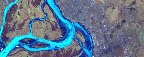
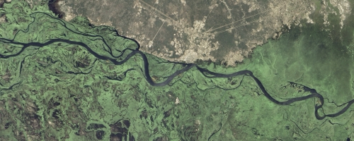
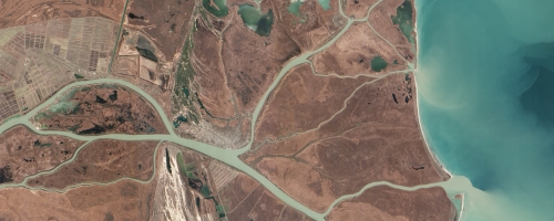
13 July 2018 - Yangtze River delta & Shanghai, China:
The Copernicus Sentinel-3A satellite takes us over Shanghai, China. One of the most populous cities in the world and home to over 24 million people, the city is visible in the lower right of the image just above the Yangtze River mouth. As a significant global financial centre it is also the site of the world's busiest container ports because of its strategic location on the Yangtze River delta.
This true colour image taken using Sentinel-3A's Ocean and Land Colour Instrument (OLCI) shows the huge amount of sediment carried into the ocean along the coast.
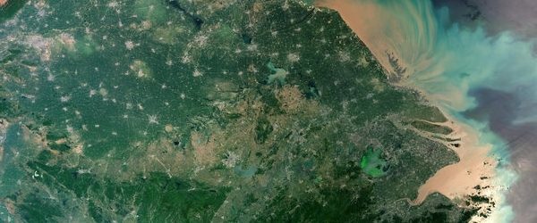
Credit: contains modified Copernicus Sentinel data (2017), processed by ESA, CC BY-SA 3.0 IGO
12 March 2018 - Sarawak's Rajang River Delta
In Sarawak, rivers stem from rivers stemming from even larger rivers. The snake-like nature and sharp turns of these waterways resemble a painting when viewed from space, but the causes of these patterns are rooted in nature.
On 16 June 2016, the Operational Land Imager (OLI) on the Landsat 8 satellite acquired this image of the Sarawak River Delta on the island of Borneo in East Malaysia.

Credit: NASA Earth Observatory
15 May 2017 - Uintah Basin, United States
Rivers cut through the landscape, along which we can see patches of agriculture appearing bright red in this false-colour image – a stark contrast to the less-vegetated areas across the semi-arid region.
Surrounded by fields in the upper left is the city of Vernal. Areas like buildings and parking lots with no vegetation appear blue and white. The long, light-brown rectangle shows the location of the regional airport.

Credit: contains modified Copernicus Sentinel data (2016), processed by ESA, - Additional editing and text by the eoPortal team.
21 September 2016 - Yukon River, Canada
The windy Yukon River ambles through this Flock-1 image from 19 September 2016.
The satellite caught the snow covered Old Crow Flats, deep inside the Arctic Circle, a vast wetland residing within Canada's Vunut National Park.
Notice in particular how the September snows cover the landscape, but the various bodies of water are still free of ice.

Credit: Image © 2016 Planet Labs Inc. - Additional editing by the eoPortal team
03 September 2016 - White River, South Dakota
An astronaut aboard the International Space Station focused a camera on the White River where it pours milky-colored water into the blue-green of Lake Francis Case.
The White River's name—Makhízita wakpá, or "White Dirt River" in the Lakota language—derives from the white sediment it carries from erosion and weathering of rocks and soils upstream, especially limestone and volcanic ash from sources near South Dakota's Badlands.

Credit: NASA Earth Observatory
04 June 2015 - Paraná, Uruguay and Plata Rivers, Argentina
The convergence of three rivers in Argentina can be seen in this image taken from the International Space Station on 6 April 2015.
On the left the Paraná River delta pours muddy water into the wide Plata River to the right of the image. Also visible is backwash pushing muddy water from the Paraná upstream into the smaller Uruguay River above.
Credit: NASA Earth Observatory
16 March 2015 - Araguaia River, Brazil
The Araguaia River is pictured in this Flock 1 image, acquired on 15 February 2015. The river is approximately 2600 kilometres long, and passes through the Mato Grosso and Goiás states.
The red colour of the water in this image is the result of large amounts of sediment in the river.
Credit: Image © 2015 Planet Labs Inc. - Additional editing by the eoPortal team
05 February 2015 - Rong Jiang (South River), China
The Rong Jiang (South River) is pictured in this Flock 1 image, acquired on 15 January 2015.
In the image, the river can be seen passing through the Jieyang City, and is joined by clearer water from the Heng River, which is sourced from a reservoir.
Credit: Image © 2015 Planet Labs Inc. - Additional editing by the eoPortal team
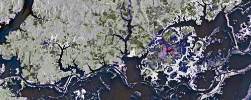
29 December 2014 - Rufiji River, Tanzania
The Rufji River delta is pictured in this image from the Flock 1 constellation. Acquired on 10 December 2014, the image shows streams branching from the main body of the river near the coast of the Indian Ocean.
The Rufiji is located wholly within Tanzania, and is home to the largest mangrove forest in east Africa.
Credit: Image © 2014 Planet Labs Inc. - Additional editing and text by the eoPortal team
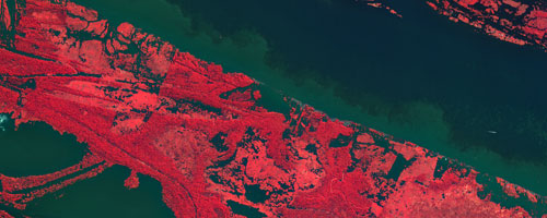
08 December 2014 - Betsiboka River and Bombetoka Bay, Madagascar
This image, from the Flock 1 constellation on 01 December 2014, shows the Betsiboka River and Bombetoka Bay in Madagascar. The distinctive red colour of the river and floodplain is caused by soil erosion in the highlands further up the river.
The Betsiboka River is one of the longest in Madagascar, but the huge amounts of erosion over the last few decades is threatening the health of the estuary as sediment fills it.
Credit: Image © 2014 Planet Labs Inc. - Additional editing and text by the eoPortal team
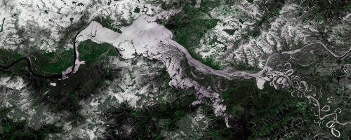
05 December 2014 - Rio Mamoré
The Rio Mamoré can be seen in this image from the Landsat 8 satellite. Acquired on 13 July 2014, it is one half of an image comparison with the Landsat 5 satellite, which acquired a view of this same area 28 years earlier to study how the river has changed.
The Mamoré extends from top to bottom in this image, and is joined by the Rio Grande (moving diagonally across the right side of the image).
Credit: NASA Earth Observatory / United States Geological Survey (USGS)
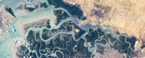
30 October 2014 - Niger River Delta, Mali
Astronauts aboard the International Space Station took this photograph of the inland delta of the Niger River, located in Mali, on 17 October 2014.
The delta, and the Niger River, have long been a vital source of water for inhabitants of the area, due to its proximity to the Sahara Desert.
The Niger River extends across western Africa, and originates in Guinea. From there it passes through Mali, Niger and Nigeria before emptying into the Atlantic Ocean.
Credit: NASA Earth Observatory
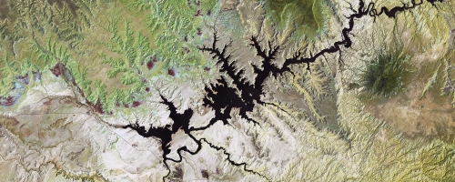
27 May 2014 - Lake Powell, United States of America
This Landsat 8 image, acquired 13 May 2014, features part of the Colorado River and Lake Powell, in Utah. This follows on from the images we previously featured last year from the International Space Station and NASA's EO-1 and Landsat 5 satellites.
Lake Powell has now experienced 14 years of drought, and this ongoing situation is clearly visible in this image. NASA's Earth Observatory World of Change feature also highlights the changes to the area dating back to 1999.
Credit: NASA Earth Observatory
02 April 2014 - Zambezi River, Zambia
This colourful view of the Zambezi River is a multitemporal radar image acquired by ESA's Envisat satellite. Composed of three different images, the composite examines change in the Zambezi River's floodplains in western Zambia.
The individual images were acquired on 1 March, during the wet season, 27 September and 26 December, when water levels were low, all during 2011. Combined, the psychedelic array of colours reveal how drastically the floodplain changes between seasons.
Credit: European Space Agency (ESA)
27 December 2013 - Amazon River, Brazil
This KOMPSAT-2 image, acquired on 6 July 2012, shows the Amazon River in the heart of northern Brazil's rainforest.
The Amazon is one of the longest rivers in the world, and there is some debate as to whether the Amazon or the Nile is in fact the longest. The Amazon is almost 7000 kilometres in length and runs through Brazil, Colombia and Peru, emptying into the Atlantic Ocean.
The Amazon River is famous for its dense forestation and variety of wildlife along its banks.
Credit: Korea Aerospace Research Institute (KARI) / European Space Agency (ESA)
13 December 2013 - Zambezi River Delta, Mozambique
We return to the Zambezi River in this Landsat-8 image, acquired on 29 August 2013. This image features the Zambezi River Delta on the coast of Mozambique.
The Zambezi drains a watershed that spans eight countries and nearly 1.6 million square kilometres (600,000 square miles). The Zambezi (also Zambeze) is the fourth largest river in Africa, and the largest east-flowing waterway. From headwaters in Zambia, it rolls across 2,574 kilometres (1,599 miles) of the south-central African plateau before pouring water and sediment into the Indian Ocean through a vast delta in Mozambique.
Credit: NASA Earth Observatory
03 September 2013 - Okavango River Delta, Botswana
This multi-temporal Envisat image shows the Okavango River Delta in northern Botswana. It is a compilation of three images from Envisat's radar on 15 September 2009, 29 December 2009 and 5 October 2010.
The delta is fed by the Okavango River, which originates in Angola, forms part of the Angola Namibia border and then ends in northern Botswana. Here, it has formed a depression in the semi-arid Kalahari basin.
Credit: European Space Agency (ESA)
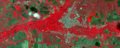
29 August 2013 - Amur River, Russia
This SPOT-5 image, acquired 26 August 2013, shows flooding along the Amur River in the Leninsky District of Russia.
Eastern Russia is currently experiencing widespread flooding, which is reportedly the worst encountered in the area in many years.
The effects of the flooding on the Amur River can be seen in this image, as the Leninskoye village, which can be seen in the centre of the image, has been turned into an island by the floodwaters.
Credit: CNES 2013, Astrium Services, ScanEx RDC
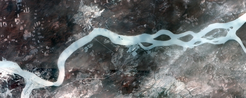
26 July 2013 - Ob River, Russia
This image, acquired by SPOT-5 on 22 July 2013, shows the Ob River and branches of it in the October District in the Khanty-Mansi region of Russia.
Credit: CNES 2013, Astrium Services, ScanEx RDC
13 June 2013 - Elbe River, Germany
On 07 June 2013, the Operational Land Imager on Landsat-8 captured a natural-colour image of flooding near Wittenberg, in the German state of Saxony-Anhalt.
Unprecedented rainfall and flooding continued to plague central Europe in mid-June 2013, causing billions of dollars in damage. The Elbe, Danube, Saale, and other river systems rose well above their banks and breached flood defences in Germany, Austria, the Czech Republic, Hungary, and Slovakia. Many news outlets and some government sources were describing it as the worst flooding since medieval times, surpassing the devastating floods of 2002 in many areas.
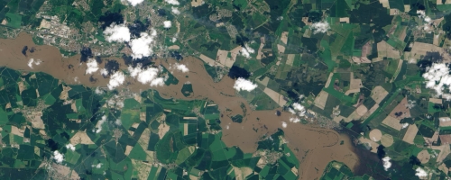
Credit: NASA Earth Observatory / United States Geological Survey (USGS)
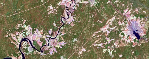
06 June 2013 - Danube, Ilz and Inn Rivers, Germany
This Pléiades image acquired on 05 June 2013 shows the severe flooding of the Bavarian city Passau.
In the historic city centre of Passau the rivers Inn, Danube and Ilz converge. Following several days of severe rainfall at the end of May and during the first days of June 2013 the water levels reached 12.85m, overflowing the highest recorded historic flood level.
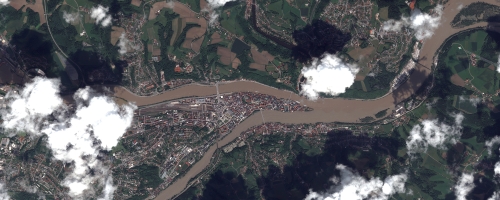
Credit: CNES 2013 - Distribution: Astrium Services / Spot Image S.A. France, all rights reserved
30 May 2013 - Ural River, Russia
This UK-DMC2 image, acquired 20 May 2013, shows part of the Ural River as it passes by the city of Orenburg. The river was once called the Yaik and it was renamed by the order of the Empress Catherine II in 1775. Ural is the third longest river in Europe after the Volga and Danube Rivers.
Credit: DMCii, ScanEx RDC 2013
27 May 2013 - Okavango River
This KOMPSAT-2 image, acquired 03 January 2013, shows part of the Okavango River, which forms the border between Namibia and Angola.
This river originates in Angola, and flows south east where it eventually fans out to create an inland delta in Botswana. The delta is a popular tourist destination boasting a variety of wildlife such as elephant, buffalo, wildebeest, giraffe, lion, leopard, cheetah, crocodile, hyena, rhinoceros and baboon.
Credit: Korea Aerospace Research Institute (KARI) / European Space Agency (ESA)
21 May 2013 - Indus River Delta, Pakistan
The western edge of the Indus River Delta can be seen in this astronaut photograph from the International Space Station, taken on 20 April 2013.
The delta is formed by the Indus River flowing into the Arabian Sea, and covers a wide and varying area. This part of the delta borders Korangi, part of Karachi, and highlights the stark contrast between the urban neighbourhoods and lush vegetation of the delta.
Credit: NASA Earth Observatory
17 May 2013 - Chusovaya River, Russia
This SPOT-5 image, acquired 12 May 2013, shows the Chusovaya River, in the Chusovskoy District of Russia. The river's source is on the eastern slopes of the Urals range, in Asia, while the main portion is located in the European part of Russia. The river usually breaks up in late April and gets shallow in summer. In this image it is almost fully free from ice.
Credit: Spot Image, ScanEx RDC 2013
16 May 2013 - Nhamundá River and Amazon Basin
Part of the Amazon Basin in northern Brazil and the Nhamundá River can be seen in this image from the Japanese ALOS satellite.
This river is one of the many tributaries of the Amazon, which is located just to the south of this image (not pictured).
Legend says that at the mouth of the Nhamundá River, Spanish explorer Francisco de Orellana encountered large, muscular female warriors that reminded him of the 'Amazon women' of Greek mythology. It is believed that the explorer - who completed the first known navigation of the Amazon River - named it so after this incident.
Credit: Japan Aerospace Exploration Agency (JAXA), European Space Agency (ESA)
10 May 2013 - Lake Powell, United States of America
We return to Lake Powell, in Utah, again with this image from NASA's EO-1 satellite, acquired on 26 April 2013. Following up on the previous images from the International Space Station and Landsat 5 this image clearly demonstrates the continuing drought that is affecting the area.
Credit: NASA Earth Observatory
09 May 2013 - Amur and Ussuri Rivers, Russia
Parts of the Amur and Ussuri Rivers can be seen in this SPOT-5 image, acquired 01 December 2012. The confluence of these two rivers is the city of Khaborovsk, which can be seen to the right of the rivers.
The Amur River forms part of the natural border between Russia and China, and has long been historically important to both nations.
Smaller than the Amur River, the Ussuri also forms part of the border between Russia and China, and stretches out through the Khabarovsk and Primorsky Krais.
Credit: Spot Image, ScanEx RDC 2013
18 April 2013 - Kama and Ik Rivers, Russia
The Nizhnekamskoye water reservoir, created in 1979 in the Kama river valley, can be seen in the centre of this UK-DMC2 image. Connected to this are the Kama and Ik Rivers, which can be seen to the left and right of the reservoir.
The Kama River is one of Russia's major rivers and a tributary of the Volga River, which is the longest in Europe.
Credit: DMCii, ScanEx RDC 2013
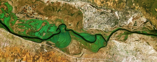
10 April 2013 - Zambezi River
The Advanced Land Imager (ALI) on NASA's Earth Observing-1 (EO-1) satellite observed this stretch of the Zambezi River on 31 March 2013. The Zambezi River forms part of the border between Zambia and Namibia, where the Caprivi Strip juts eastward from the rest of Namibia. Flowing down a gentle gradient in this region, the Zambezi often spills onto floodplains during the rainy season, with water levels peaking between February and April.
Credit: NASA Earth Observatory / NASA EO-1 team
09 April 2013 - The River Thames, United Kingdom
The PROBA-1 image, acquired 25 September 2010, shows part of the River Thames, wending its way through the centre of London, in the United Kingdom.
The Thames is the second-longest river in the United Kingdom and has played a key role in the history of London, starting from the earliest settlement in the area thousands of years ago.
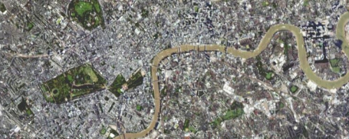
Credit: European Space Agency (ESA)
28 March 2013 - Lake Powell and Colorado River, United States of America
This Landsat-5 image features another view of the Colorado River, and focuses on Lake Powell. This false-colour image highlights the differences in terrain and the water.
Lake Powell is the second largest artificial lake in the United States of America and took 17 years to completely fill initially.
Credit: United States Geological Survey (USGS) / European Space Agency (ESA)
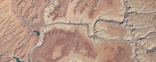
27 March 2013 - Colorado River, United States of America
This photograph, taken by an astronaut aboard the International Space Station on 12 March 2013, shows the Colorado River and adjoining Lake Powell, spanning parts of Arizona, Utah, New Mexico and Colorado in the United States of America.
The Colorado River, dammed to form Lake Powell in 1963, crosses from east to west (which is left to right here because the astronaut was looking south; north is towards the bottom of the image). The confluence of the Colorado and San Juan Rivers is also visible.
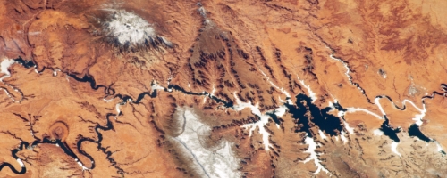
Credit: NASA Earth Observatory
21 February 2013 - Danube River
This EO-1 image shows the Danube River Delta, where it empties into the Black Sea. The Danube is the largest river in Europe, and of historical importance for many European civilisations dating back to the Neolithic period of the Stone Age.
Credit: NASA Earth Observatory
20 February 2013 - Angara and Yenisei Rivers, Russia
This SPOT-5 image, acquired 12 February 2013, shows the convergence of the Angara and Yenisei Rivers in Russia. These rivers are located in Siberia, and the Yenisei River stretches back to the Kara Sea. The Angara River is a tributary that leads to the Baikal Lake.
Credit: Spot Image, ScanEx RDC 2013